
Ahmedabad is the most populous city in the Indian state of Gujarat. It is the administrative headquarters of the Ahmedabad district and the seat of the Gujarat High Court. Ahmedabad's population of 55,70,585 makes it the fifth-most populous city in India, and the encompassing urban agglomeration population estimated at 6,357,693 is the seventh-most populous in India. Ahmedabad is located near the banks of the Sabarmati River, 25 km (16 mi) from the capital of Gujarat, Gandhinagar, also known as its twin city.
This page provides a historical timeline of Ahmedabad, the sixth largest city in India.
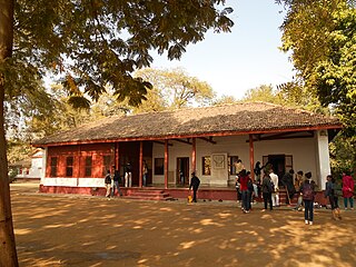
Sabarmati Ashram is located in the Sabarmati suburb of Ahmedabad, Gujarat, adjoining the Ashram Road, on the banks of the River Sabarmati, 4 miles (6.4 km) from the town hall. This was one of the many residences of Mahatma Gandhi who lived at Sabarmati (Gujarat) and Sevagram when he was not travelling across India or in prison. He lived in Sabarmati or Wardha for a total of twelve years with his wife Kasturba Gandhi and followers, including Vinoba Bhave. The Bhagavad Gita was recited here daily as part of the Ashram schedule.

Patan is the administrative seat of Patan District in the Indian state of Gujarat and is an administered municipality. It was the capital of Gujarat's Chavda and Chaulukya dynasties in medieval times, and is also known as Anhilpur-Patan to distinguish it from Prabhas Patan.
Naroda is a fast-growing area in Ahmedabad, northeast of central Ahmedabad in the Indian state of Gujarat.
Dhrangadhra is a town, taluka headquarters and a municipality in Surendranagar district in the state of Gujarat, India. During the period of the British Raj, the city was the capital of Dhrangadhra State, one of the eight first-class princely states of the Kathiawar Agency in the Bombay Presidency.

Bhinmal is an ancient town in the Jalore District of Rajasthan, India. It is 72 kilometres (45 mi) south of Jalore. Bhinmal was the capital of the Bhil king, then the capital of Gurjaradesa, comprising modern-day southern Rajasthan and northern Gujarat.
Ambaji (Ambājī) is a census town in Banaskantha district in the state of Gujarat, India. It is known for its historical connections with sites of cultural heritage.

According to the 2011 national census, the population of Ahmedabad was declared to be 7,214,225. This figure was only limited to the municipality region. The total population of the Ahmedabad Urban Agglomeration came to 7.2 million people. There were 886 females to every 1000 males in 2001. Now there are 904 women to 1000 men in 2011. Ahmedabad had a literacy rate of 79.89% in 2001 which rose to 89.62 percent in 2011. Out of this, male and female literacy are 93.96 and 84.81 percent as of 2011 census. According to the census for the ninth plan, there are 30737 rural families living in Ahmedabad. Out of those, 5.41% live below the poverty line. There are 439,843 people who live in slums in the city. The majority of residents of Ahmedabad are native Gujaratis and speak Gujarati. There is also a sizable population of Punjabis, Marathis, Tamils, Sindhis, Malayalis and Marwaris who bring in their native language and culture to the city. The government institutions and military base near the city also bring peoples from across India. The city's population has increased in a major way following increasing economic expansion and modernization.
Mahemdavad is a town with municipality in the Kheda district in the Indian state of Gujarat. Mahemdavad is situated on the Vatrak River bank. The nearest city is Kheda. It is 30 km from largest city of Gujarat, Ahmedabad.
Mahuva is a town and taluka of Bhavnagar District, in the state of Gujarat, India. Located on the coast of the Arabian Sea, Mahuva is known for its mild weather and green, lush surroundings, including many coconut tree plantations. The town is a part of the Saurashtra region and is known as the Kashmir of Saurashtra. Mahuva is also known for wooden toys, raw onions, groundnuts, and a local variety of mango called the Jamadar. The region is home to a thriving agribusiness industry, particularly enterprises that dehydrate vegetables such as garlic and onions for use in processed foods.
Rajula is a city and municipality in Amreli district in the Indian state of Gujarat. City was known as Rajgadh at the time of local ruler daha dhakhda.
Una is a city and a municipality in Gir Somnath district of the Saurashtra region in the state of Gujarat, India.
Ode is a small town and a municipality in Anand district in the Indian state of Gujarat.
Shirpur is a town and taluka in Dhule district of Nashik Division, Maharashtra. It is located on National Highway 3, which runs from Agra in Uttar Pradesh to Mumbai, Maharashtra. The Arunavati River and Tapi river flows through the city. Shirpur is 50 km from the city of Dhule. It home of Asia's largest and India's first gold refinery. Narsee Monjee Institute of Management Studies has a campus in Shirpur. Ahead of Shirpur there is a small private airport at Village Tande.
Shihori is a village in Banaskantha district of the Indian state of Gujarat. It is the administrative headquarters of the Kankrej Taluka and has a population of more than 10,000.

Saldi is a village in the Mehsana District, Gujarat, India, Pin Code 382730, situated on State Highway 217 between Gandhinagar and Mehsana. Saldi represents a typical countryside village of India. It borders the following villages: langhnaj, Veda, Parsa, Charadu, Vadasma, Shankarpura, Khata Amba, Khoraj and Himatpura. Saldi is famous for its temple of Pimpleshwar Mahadev, about 1 kilometre from the Saldi town square.

Gujarat is the 6th largest state in India, located in the western part of India with a coastline of 1,600 km. It is a popular tourist destination in the country and was visited by 19.5 million domestic tourists and 210 thousand international tourists in 2020.
Sabarmati is an area located in Ahmedabad, India.
Jagana is a village in the Palanpur taluka of Banaskantha district in northern Gujarat, India. The villages Vasna, Bhagal, Sedrasana are located near to Jagana and it is just 6 km away from the district headquarters, Palanpur.


