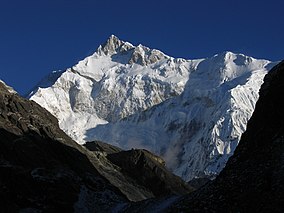
Kangchenjunga, also spelled Kanchenjunga, Kanchanjanghā and Khangchendzonga, is the third-highest mountain in the world. Its summit lies at 8,586 m (28,169 ft) in a section of the Himalayas, the Kangchenjunga Himal, which is bounded in the west by the Tamur River, in the north by the Lhonak River and Jongsang La, and in the east by the Teesta River. It lies in the border region between Nepal and Sikkim state of India, with three of the five peaks, namely Main, Central and South, directly on the border, and the peaks West and Kangbachen in Nepal's Taplejung District.

Sikkim is a state in northeastern India. It borders the Tibet Autonomous Region of China in the north and northeast, Bhutan in the east, Koshi Province of Nepal in the west, and West Bengal in the south. Sikkim is also close to the Siliguri Corridor, which borders Bangladesh. Sikkim is the least populous and second smallest among the Indian states. Situated in the Eastern Himalaya, Sikkim is notable for its biodiversity, including alpine and subtropical climates, as well as being a host to Kangchenjunga, the highest peak in India and third highest on Earth. Sikkim's capital and largest city is Gangtok. Almost 35% of the state is covered by Khangchendzonga National Park – a UNESCO World Heritage Site.

A transboundary protected area (TBPA) is an ecological protected area that spans boundaries of more than one country or sub-national entity. Such areas are also known as transfrontier conservation areas (TFCAs) or peace parks.

Nanda Devi is the second-highest mountain in India, after Kangchenjunga, and the highest located entirely within the country. Nanda Devi is the 23rd-highest peak in the world.
Valley of Flowers National Park is an Indian national park which was established in 1982. It is located in Chamoli in the state of Uttarakhand and is known for its meadows of endemic alpine flowers and the variety of flora. This richly diverse area is also home to rare and endangered animals, including the Asiatic black bear, snow leopard, musk deer, brown bear, red fox and blue sheep. Birds found in the park include Himalayan monal pheasant and other high altitude birds.

Gyalshing District or Geyzing District is a district of the Indian state of Sikkim. Its headquarter is Geyzing, also known as Gyalshing. The district is a favourite with trekkers due to the high elevations. Other important towns include Pelling and Yuksom. Local people also call it as Pallo-Sikkim and Sano-Sikkim commonly.

Yuksom is a historical town in Geyzing subdivision of West Sikkim district in the Northeast Indian state of Sikkim. It was the first capital of Kingdom of Sikkim established in 1642 AD by Phuntsog Namgyal who was the first Chogyal of Sikkim. The coronation site of the first monarch of Sikkim is known as the "Throne of Norbugang". Yuksom is where there is the Norbugang Chorten near the Norbugang throne, the place Namgyal was crowned and several monasteries and a lake. The dynastic rule of the Chogyals lasted for 333 years.

Singalila National Park is a National park of India located on the Singalila Ridge at an elevation of more than 2300 metres above sea level, in the Darjeeling district of West Bengal. It is well known for the trekking route to Sandakphu that runs through it.
Shingba Rhododendron Sanctuary is a nature park in the Indian state of Sikkim. It has forty species of rhododendron trees. It is located in the Yumthang Valley of Flowers north of Lachung in North Sikkim district. Bird species found in the park include Wood snipe and Hoary-throated barwing. The sanctuary is part of the Sacred Himalayan Landscape.
Kangchenjunga is the third highest mountain in the world.

Manas National Park is a national park, Project Tiger reserve, and an elephant reserve in Assam, India. Located in the Himalayan foothills, it borders the Royal Manas National Park in Bhutan. The park is known for its rare and endangered endemic wildlife such as the Assam roofed turtle, hispid hare, golden langur and pygmy hog. Manas is also famous for its population of the wild water buffalo. Because of its exceptional biodiversity, scenery, and variety of habitats, Manas National Park is a biosphere reserve and a UNESCO World Heritage Site.
Kyongnosla Alpine Sanctuary is a nature reserve in Gangtok district, Sikkim, India. It is situated around the area adjoining the Tsomgo (Changu) lake along the Nathula Road. Located about 31 km (19 mi) east of Gangtok, the capital of Sikkim, this sanctuary covers an area of about 31 km2 (12 sq mi), and extends from the "15th Mile" police check point up to and along the ridges bordering the Rong Chu Valley and Lake Tsomgo.

The Eastern Himalayan broadleaf forests is a temperate broadleaf forest ecoregion found in the middle elevations of the eastern Himalayas, including parts of Nepal, India, Bhutan, Myanmar and China. These forests have an outstanding richness of wildlife.
India is home to a large variety of wildlife. It is a biodiversity hotspot with various ecosystems ranging from the Himalayas in the north to the evergreen rainforests in the south, the sands of the west to the marshy mangroves of the east. India lies within the Indomalayan realm and is home to about 7.6% of mammal, 14.7% of amphibian, 6% of bird, 6.2% of reptilian, and 6.2% of flowering plant species. India's forests contain about 500 species of mammals and more than 1300 bird species.

Kanchenjunga Conservation Area is a protected area in the Himalayas of eastern Nepal that was established in 1997. It covers 2,035 km2 (786 sq mi) in the Taplejung District and comprises two peaks of Kanchenjunga. In the north it adjoins the Qomolangma National Nature Preserve in Tibet, and in the east the Khangchendzonga National Park in Sikkim. To the west it borders the Sankhuwasabha District. It ranges in elevation from 1,200 to 8,586 m. It is part of the Sacred Himalayan Landscape, which is being developed by WWF Nepal in partnership with the International Centre for Integrated Mountain Development.

Cold Desert Biosphere Reserve is a biosphere reserve located in the Western Himalayas, within Himachal Pradesh in North India. It was established as a biosphere reserve in August 2009. Biosphere reserves are the areas of terrestrial and coastal ecosystems which promote the conservation of biodiversity with its sustainable use. There are over 738 biosphere reserves around the world in over 134 countries. The ministry of environment and forest provides financial assistance to the respective state governments for conservation of landscape, biological diversity and the cultural heritage. This region has the status of a Cold Desert biome. This region carries the status of a Cold Desert biome for two reasons, one is the leeward part of the Himalayas which is spared from monsoon winds and the other is its position at high altitude, on average 3000–5000 metres.

The Sacred Himalayan Landscape is a 39,021 km2 (15,066 sq mi) large trans-boundary landscape in the eastern Himalayas encompassing temperate broadleaf and conifer forests, alpine meadows and grasslands, which harbour more than 80 mammal and more than 440 bird species. It extends from Nepal's Langtang National Park through Sikkim and Darjeeling in India to western Bhutan's Torsa Strict Nature Reserve. More than 73% of this landscape is located in Nepal, including Sagarmatha National Park, Makalu Barun National Park, and Kanchenjunga Conservation Area. About 24% is located in India, encompassing Khangchendzonga, Singalila and Neora Valley National Parks as well as Fambong Lho, Maenam, Senchal, Mahananda Wildlife Sanctuaries, Shingba and Barsey Rhododendron Sanctuaries and Kyongnosla Alpine Sanctuary.
Pangolakha Wildlife Sanctuary is a wildlife reserve in the Pakyong District of the state of Sikkim in India. It is about 28 kilometres (17 mi) east of Rorathang and about 40 kilometres (25 mi) by road from Rangpo city. The total notified area of the park is around 124 square kilometres (48 sq mi) while inside the wildlife sanctuary there are a few hamlets: Aritar, Dakline Lingtam, Phadamchen, Dzuluk, Gnathang Monastery Kupup. This wildlife sanctuary is linked to the forests of Neora Valley National Park of West Bengal as well as forests of Samtse, Bhutan and Haa district Bhutan. The area that comes under this biosphere has been declared in 1999 as a wildlife sanctuary under biogeographic province category 2C.

Northeast India consists of the eight states Arunachal Pradesh, Assam, Manipur, Meghalaya, Mizoram, Nagaland, Sikkim and Tripura. Tourism in this area is based around the unique Himalayan landscape and culture distinct from the rest of India.
Tholung Monastery is a gompa located in remote upper Dzongu, in the buffer zone of Khangchendzonga National Park. It is considered one of the most sacred monasteries in Sikkim. Tholung literally means Areasima place or Areasima country.