
India is situated north of the equator between 8°4' north to 37°6' north latitude and 68°7' east to 97°25' east longitude. It is the seventh-largest country in the world, with a total area of 3,287,263 square kilometres (1,269,219 sq mi). India measures 3,214 km (1,997 mi) from north to south and 2,933 km (1,822 mi) from east to west. It has a land frontier of 15,200 km (9,445 mi) and a coastline of 7,516.6 km (4,671 mi).

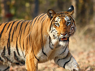
The Bay of Bengal is the northeastern part of the Indian Ocean, bounded on the west and northwest by India, on the north by Bangladesh, and on the east by Myanmar and the Andaman and Nicobar Islands of India. Its southern limit is a line between Sangaman Kanda, Sri Lanka and the north westernmost point of Sumatra (Indonesia). It is the largest water region called a bay in the world. There are countries dependent on the Bay of Bengal in South Asia and Southeast Asia. During the existence of British India, it was named as the Bay of Bengal after the historic Bengal region. At the time, the Port of Kolkata served as the gateway to the Crown rule in India. Cox's Bazar, the longest sea beach in the world and Sundarbans, the largest mangrove forest and the natural habitat of the Bengal tiger, are located along the bay.

Andaman and Nicobar Islands is a union territory of India consisting of 572 islands, of which 38 are inhabited, at the junction of the Bay of Bengal and the Andaman Sea.

The Andaman Sea is a marginal sea of the northeastern Indian Ocean bounded by the coastlines of Myanmar and Thailand along the Gulf of Martaban and west side of the Malay Peninsula, and separated from the Bay of Bengal to its west by the Andaman Islands and the Nicobar Islands. Its southernmost end is defined by Breueh Island, an island just north of Sumatra, and communicates with the Malacca Strait.

Lakshmibai, the Rani of Jhansi, was the Maharani consort of the Maratha princely state of Jhansi from 1843 to 1853 as the wife of Maharaja Gangadhar Rao. She was one of the leading figures of the Indian Rebellion of 1857 and became a symbol of resistance to the British Raj for Indian nationalists. She died in the Rebellion, from wounds received in a battle on 18 June 1858. The Rebellion was suppressed by November that year.
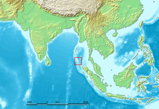
The Nicobar Islands are an archipelagic island chain in the eastern Indian Ocean. They are located in Southeast Asia, 150 km north of Aceh on Sumatra, and separated from Thailand to the east by the Andaman Sea. Located 1,300 km southeast of the Indian subcontinent, across the Bay of Bengal, they form part of the Union Territory of Andaman and Nicobar Islands, India.

Jhansi is a historic city in the Indian state of Uttar Pradesh. It lies in the region of Bundelkhand on the banks of the Pahuj River, in the extreme south of Uttar Pradesh. Jhansi is the administrative headquarters of Jhansi district and Jhansi division. Also called the Gateway to Bundelkhand, Jhansi is situated near and around the rivers Pahuj and Betwa at an average elevation of 285 m (935 ft). It is about 420 kilometres (261 mi) from New Delhi and 102 kilometres (63 mi) south of Gwalior.

The Sundarbans National Park is a national park, tiger reserve, and biosphere reserve in West Bengal, India. It is part of the Sundarbans on the Ganges Delta, and adjacent to the Sundarban Reserve Forest in Bangladesh. The delta is densely covered by mangrove forests, and is one of the largest reserves for the Bengal tiger. It is also home to a variety of bird, reptile and invertebrate species, including the salt-water crocodile. The present Sundarban National Park was declared as the core area of Sundarban Tiger Reserve in 1973 and a wildlife sanctuary in 1977. On 4 May 1984 it was declared a national park. It is a UNESCO World Heritage Site inscribed in 1987, and it has been designated as a Ramsar site since 2019. It is considered as a World Network of Biosphere Reserve from 1989.

Ritchie's Archipelago is a cluster of smaller islands which lie 20 km (12 mi) east of Great Andaman, the main island group of the Andaman Islands. The Islands belong to the South Andaman administrative district, part of the Indian union territory of Andaman and Nicobar Islands.

The Surin Islands is an archipelago of five islands in the Andaman Sea, 60 km from the Thai mainland. Administratively, the islands are part of Tambon Ko Phra Thong, Khura Buri District, in Phang Nga Province, Thailand.
Mahatma Gandhi Marine National Park is a national park of India near Wandoor on the Andaman Islands. It belongs to the South Andaman administrative district, part of the Indian union territory of Andaman and Nicobar Islands.
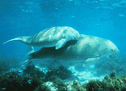
The Gulf of Mannar Marine National Park is a protected area of India consisting of 21 small islands (islets) and adjacent coral reefs in the Gulf of Mannar in the Indian Ocean. It lies 1 to 10 km away from the east coast of Tamil Nadu, India for 160 km between Thoothukudi (Tuticorin) and Dhanushkodi. It is the core area of the Gulf of Mannar Biosphere Reserve which includes a 10 km buffer zone around the park, including the populated coastal area. The park has a high diversity of plants and animals in its marine, intertidal and near shore habitats. Public access inside the park is limited to glass-bottom boat rides.

Middle Button Island National Park is an Indian national park located in the Andaman and Nicobar Islands. The park was created in 1979 and is situated about 200 km (124 mi) northeast of Port Blair, capital of the island group. The total area that the national park covers is about 64 km2 (25 sq mi). Along with the neighbouring islands of North Button and South Button, both also national parks, it forms part of the Rani Jhansi Marine National Park off the coast of South Andaman Island.
South Button Island National Park is a national park located in the Andaman and Nicobar Islands off the coast of India, the total area of this protected island is about 5 km2 (2 sq mi). Along with the neighbouring islands of North Button and Middle Button, both also national parks, it forms part of the Rani Jhansi Marine National Park off the coast of South Andaman Island. South Button National Park in Andaman and Nicobar islands is the smallest National park in India.

Mount Harriet National Park is a national park located in the Andaman and Nicobar Islands union territory of India. The park, established in 1969, covers about 4.62 km2 (18.00 mi2). Mount Harriet, which is part of the park, is the third-highest peak in the Andaman and Nicobar archipelago next to Saddle Peak in North Andaman and Mount Thullier in Great Nicobar.
India is home to a large variety of wildlife. It is a biodiversity hotspot with its various ecosystems ranging from the Himalayas in the north to the evergreen rain forests in the south, the desert sands of the west to the marshy mangroves of the east. India lies within the Indomalayan realm and is the home to about 7.6% of mammal, 14.7% of amphibian, 6% of bird, 6.2% of reptilian, and 6.0% of flowering plant species. India's forest lands nurture about 500 species of mammals and 2000+ bird species.
Global mangrove distributions have fluctuated throughout human and geological history. The area covered by mangroves is influenced by a complex interaction between land position, rainfall hydrology, sea level, sedimentation, subsidence, storms and pest-predator relationships). In the last 50 years, human activities have strongly affected mangrove distributions, resulting in declines or expansions of worldwide mangrove area. Mangroves provide several important ‘free services’ including coastal stabilization, juvenile fish habitats, and the filtration of sediment and nutrients). Mangrove loss has important implications for coastal ecological systems and human communities dependent on healthy mangrove ecosystems. This English Wikipedia page presents an overview of global mangrove forest biome trends in mangrove ecoregions distribution, as well as the cause of such changes.

Kanmaw Kyun or Kanmaw Island is an island in the Andaman Sea along the coast of southeastern Burma (Myanmar), and is part of the Mergui Archipelago. Administratively, it is located in Kyunsu Township, Myeik District, in the Taninthayi Region. On the northeastern side of the island is the town of Kyunsu, which is the administrative seat for the township. The island covers a total area of 409 km2.

The Moscos Islands are an island chain in the Andaman Sea, right off the northern coast of the Tanintharyi Region, in the southern area of Burma.
Button Islands are a group of islands of the Andaman Islands. It belongs to the South Andaman administrative district, part of the Indian union territory of Andaman and Nicobar Islands.