Bodmin Moor is a granite moorland in north-eastern Cornwall, England, United Kingdom. It is 208 square kilometres (80 sq mi) in size, and dates from the Carboniferous period of geological history. It includes Brown Willy, the highest point in Cornwall, and Rough Tor, a slightly lower peak. Many of Cornwall's rivers have their sources here. It has been inhabited since at least the Neolithic era, when primitive farmers started clearing trees and farming the land. They left their megalithic monuments, hut circles and cairns, and the Bronze Age culture that followed left further cairns, and more stone circles and stone rows. By medieval and modern times, nearly all the forest was gone and livestock rearing predominated.
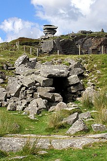
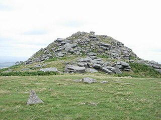
A tor, which is also known by geomorphologists as either a castle koppie or kopje, is a large, free-standing rock outcrop that rises abruptly from the surrounding smooth and gentle slopes of a rounded hill summit or ridge crest. In the South West of England, the term is commonly also used for the hills themselves – particularly the high points of Dartmoor in Devon and Bodmin Moor in Cornwall.

The Longships is the name given to a group of rocky islets situated approximately 11⁄4 miles (2 km) west of Land's End, Cornwall, England, United Kingdom. The islets are marked by the Longships Lighthouse, the current structure being first lit in December 1873. The islets are very popular for recreational diving, the sea has clear water with prolific marine life and flora.

The culture of Cornwall forms part of the culture of the United Kingdom, but has distinct customs, traditions and peculiarities. Cornwall has many strong local traditions. After many years of decline, Cornish culture has undergone a strong revival, and many groups exist to promote Cornwall's culture and language today.
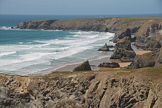
Carnewas and Bedruthan Steps is a stretch of coastline located on the north Cornish coast between Padstow and Newquay, in Cornwall, England, United Kingdom. It is within the parish of St Eval and is part-owned by the National Trust. The trust maintains a shop and café, and the cliff–top views of rocks stretching into the distance along Bedruthan beach make the area a popular attraction for tourists and painters. The property affords walks along the coast path and the steep steps at Bedruthan allow access to a series of rocky beaches at low tide. Signs at the top of the steps down to the beaches warn visitors not to risk swimming in these waters due to heavy rips, fast tides, and submerged rocks.

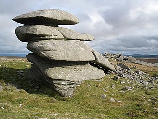
Rocking stones are large stones that are so finely balanced that the application of just a small force causes them to rock. Typically, rocking stones are residual corestones formed initially by spheroidal weathering and have later been exposed by erosion or glacial erratics left by retreating glaciers. Natural rocking stones are found throughout the world. A few rocking stones might be man-made megaliths.

Roche is a civil parish and village in mid-Cornwall, England, United Kingdom. The village gets its name from the 20-metre (66-foot) high Roche Rock, a quartz-schorl outcrop east of the village. Roche is the Norman-French word for Rock. The parish population at the 2011 census including Belowda, Bilberry, Carbis, Coldvreath and Criggan is 3,381, and the ward population at the same census was 3,867.

Saint Nectan's Kieve in Saint Nectan's Glen, near Tintagel in Cornwall, Great Britain, is a plunge pool or basin fed by a 60-foot-high (18 m) waterfall on the Trevillet River.

Cornish mythology is the folk tradition and mythology of the Cornish people. It consists partly of folk traditions developed in Cornwall and partly of traditions developed by Britons elsewhere before the end of the first millennium, often shared with those of the Breton and Welsh peoples. Some of this contains remnants of the mythology of pre-Christian Britain.
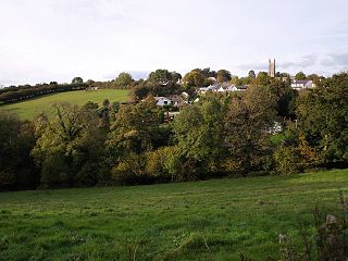
Linkinhorne is a civil parish and village in southeast Cornwall, England, United Kingdom. The village itself is situated at grid reference SX 320 736 and is approximately four miles (6.5 km) northwest of Callington and seven miles (11 km) south of Launceston. The parish population at the 2011 census including Downgate was 1,541
North Hill is a village and civil parish in Cornwall, England, United Kingdom. The village is situated on the east side of the River Lynher approximately six miles (10 km) southwest of Launceston.
Minions is a village in Cornwall, England, United Kingdom. It is situated on the eastern flank of Bodmin Moor northwest of Caradon Hill approximately four miles (6 km) north of Liskeard. Minions is first recorded in 1613 and its meaning is unknown.

Pensilva is a village in the civil parish of St Ive and Pensilva, in east Cornwall, England, United Kingdom. It is at OS grid ref SX291697 about four miles (6 km) northeast of Liskeard. Nearby settlements include Charaton Cross and Middlehill.
Trencrom Hill is a prominent hill fort, owned by the National Trust, near Lelant, Cornwall. It is crowned by an univallate Neolithic tor enclosure and was re-used as a hillfort in the Iron Age. Cairns or hut circles can be seen in the level area enclosed by the stone and earth banks. The hill overlooks the Hayle Estuary and river, and Mount's Bay and St Michael's Mount can be seen to the south. The hill was recorded as Torcrobm in 1758 which is derived from Cornish "torr crobm", i.e. 'hunched bulge'.
Showery Tor is a rocky outcrop on a ridge-top approximately 0.6 kilometres (0.37 mi) north of the Rough Tor summit, near Camelford on Bodmin Moor in Cornwall. It is notable for its rock formations and prehistoric monuments.

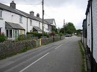
Sharptor is a hamlet west of Henwood in the civil parish of Linkinhorne in east Cornwall, England, United Kingdom. It is named after Sharp Tor on Bodmin Moor. Sharptor is close to Minions to the south, Kingbeare in the north and Darleyford to the east. Sharptor is around 280 metres (920 ft) above sea level.

Helman Tor is a granite hill in mid Cornwall, UK with several separated tors, and is designated as a (non-statutory) County Geology Site. The hill also has a Scheduled Ancient Monument. Helman Tor is also the name of the largest nature reserve managed by the Cornwall Wildlife Trust which includes Breney Common and Red Moor. The Wildlife Trust aims to rewild the reserve, including potentially releasing beavers, as well as long-horn cattle and Cornish black pigs. Helman Tor, along with Breney Common, Red Moor and Belowda Beacon, is part of the Mid Cornwall Moors Site of Special Scientific Interest. It lies on the Saints' Way, a long-distance footpath completed in 1986.

Brown Willy is a hill in Cornwall, England, United Kingdom. The summit, at 1,378 feet above sea level, is the highest point of Bodmin Moor and of Cornwall as a whole. It is about 2+1⁄2 miles northwest of Bolventor and 4 miles southeast of Camelford. The hill has a variable appearance that depends on the vantage point from which it is seen. It bears the conical appearance of a sugarloaf from the north but widens into a long multi-peaked crest from closer range.

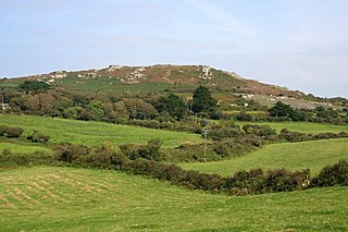
Stowe's Hill is an elongated hill, 381 metres (1,250 ft) high, located on the eastern edge of Bodmin Moor in the county of Cornwall, England.