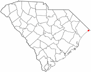
Garden City, sometimes known as Garden City Beach, is a census-designated place (CDP) in Horry County, South Carolina, United States. The population was 9,209 at the 2010 census. Garden City Beach is located directly south of Surfside Beach. The developed part of the beach extends south beyond the limits of the Garden City CDP, into Georgetown County, and ends on a peninsula at the mouth of Murrells Inlet.

Loris is a city in Horry County, South Carolina, United States. The population was 2,396 at the 2010 census, up from 2,079 in 2000.
U.S. Route 501 is a spur of U.S. Route 1. It runs 355 miles (571 km) from Buena Vista, Virginia at U.S. Route 60 to Myrtle Beach, South Carolina at U.S. Route 17 Business. It passes through the states of Virginia, North Carolina and South Carolina. From Durham to Laurinburg, a 108-mile (174 km) section of US 501 overlaps U.S. Route 15. Sections of US 15-501 also share routings with U.S. Route 1 in sections near Sanford, North Carolina and Aberdeen, North Carolina.

U.S. Route 378 is a spur of US 78 in the U.S. states of Georgia and South Carolina. The U.S. Highway runs 234.30 miles (377.07 km) from US 78, Georgia State Route 10, SR 17, and SR 47 in Washington, Georgia, east to US 501 Business in Conway, South Carolina. US 378 connects the Central Savannah River Area in both states with the Midlands and Pee Dee regions of South Carolina. The U.S. Highway's western portion, which connects Washington and Lincolnton in Georgia and McCormick, Saluda, and Lexington in South Carolina, is mainly a rural highway. US 378 is a major suburban and urban highway through Lexington and the South Carolina state capital, Columbia. The highway has a lengthy concurrency with US 76 between Columbia and Sumter and serves as a major route between the Midlands and the Myrtle Beach area, between which the highway has a business route through Lake City.

The Grand Strand is a large stretch of beaches on the East Coast of the United States extending from Little River to Georgetown in the U.S. State of South Carolina. It consists of more than 60 miles (97 km) along an essentially uninterrupted arc of beach land, beginning around the Little River and terminating at Winyah Bay. The population of the Grand Strand was 329,449 at the 2010 United States Census.

Carolina Forest is an unincorporated community in Horry County, South Carolina, United States. It lies between Myrtle Beach and Conway in an area planned by International Paper in the late 1990s. Regarded as the "bedroom community" of Myrtle Beach, the planned unit development will have 20,000 single and multi-family homesites when completed. Most of the development follows the Carolina Forest Master Plan, developed cooperatively between International Paper and the Horry County Government.
South Carolina Highway 31 (SC 31), also known as the Carolina Bays Parkway, is a six-lane, limited-access highway that parallels the Intracoastal Waterway from Myrtle Beach. The first phase opened on December 17, 2002, completing a 22-mile (35 km) link between U.S. Route 501 (US 501) and SC 9. The second phase opened in March 2005, running from US 501 southwest to and S.C. Highway 544. While usually referred to only as the Carolina Bays Parkway, the highway is also dedicated the John B. Singleton Parkway in memory of John B. Singleton, a former Myrtle Beach City Council member and police commissioner.
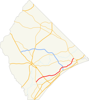
Robert Edge Parkway is a connection highway in North Myrtle Beach, South Carolina. It begins at U.S. Route 17 (US 17) and Main Street, crosses the Intracoastal Waterway, has an interchange with South Carolina Highway 31 (SC 31) or the Carolina Bays Parkway, and terminates at an intersection with SC 90. The project consisted of upgrading Firetower Road, adding a new interchange for SC 31, expanding Main Street in North Myrtle Beach to accommodate the increase in traffic, and a 1,000-foot bridge (300 m) over the Intracoastal Waterway which includes a 10-foot-wide path (3.0 m) for walkers and bicycles. Formerly known as the Main Street Connector, the road has been named for Robert Edge Sr., the first mayor of North Myrtle Beach starting in 1968. For twelve years before that, Edge was the mayor of Crescent Beach, one of the four towns which, through Edge's efforts, became North Myrtle Beach. The road opened September 3, 2009.

South Carolina Highway 9 is a 258.3-mile-long (416 km) major state highway in the U.S. state of South Carolina. The route runs from North Myrtle Beach to the North Carolina border upstate. The road is currently the longest state highway in South Carolina. It is signed as a north–south highway though overall it runs in an east–west direction.

South Carolina Highway 707 (SC 707) is a highway in Georgetown and Horry counties, South Carolina in the Myrtle Beach metropolitan area that begins at U.S. Highway 17 Business in Murrells Inlet to US 17 across from Farrow Parkway near Socastee, South Carolina.

South Carolina Highway 544 (SC 544) is a major four-lane highway in Horry County, South Carolina. The highway is sometimes known as Dick Pond Road near the Socastee area. The route begins at U.S. Route 17 Business in Surfside Beach and ends at US 501 Business in Red Hill, near Conway. South Carolina Highway 544 is one of the most frequently traversed highways in the Myrtle Beach area. It runs in a south-north direction and parallels US 501 for most of its route.

South Carolina Highway 90 is a two-lane highway from in Horry County traveling from Red Hill to Little River. It provides a direct connection from Conway to the northern Grand Strand in Little River.
South Carolina Highway 73 (SC 73) was a primary state highway in the U.S. state of South Carolina. Established five times in the state, from 1926 to 2006, its last routing was along Ocean Boulevard, in Myrtle Beach, a popular stretch of road lined with hotels, shops, tourist sites and access to the beach.
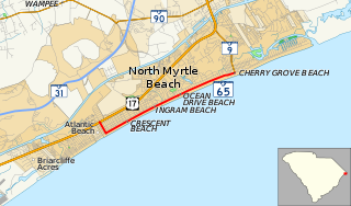
South Carolina Highway 65 is the main thoroughfare through North Myrtle Beach in the U.S. state of South Carolina. The Drive is known for the origin of the official state dance, the Carolina Shag.
Interstate 73 (I-73) is the designation for a future Interstate Highway in the U.S. state of South Carolina. When completed, it will connect the Grand Strand area with the state's interstate system.
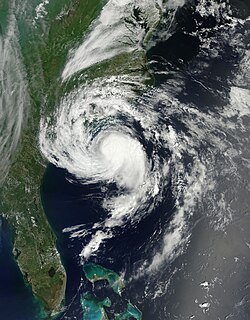
Tropical Storm Ana was the earliest recorded tropical cyclone to make landfall in the United States in any given year. A relatively rare pre-season system, Ana was the first tropical storm of the 2015 Atlantic hurricane season. It developed as a subtropical cyclone from a non-tropical low north of the Bahamas, and intensified to attain peak winds of 60 mph (97 km/h) before transitioning into a fully tropical cyclone early on May 9. Sustained in part by the warm waters of the Gulf Stream, Ana made landfall along the northeast coast of South Carolina early the next morning, becoming the earliest U.S. landfalling system on record. Overall, damage from the storm was minor. Heavy rainfall and gusty winds affected parts of the Carolinas, and some vulnerable beaches endured coastal flooding and several feet of erosion. Gusty winds damaged trees and powerlines, causing sporadic power outages, and a weak tornado was reported in association with Ana. In North Carolina, two deaths—one direct and one indirect—were attributed to the storm.