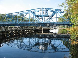
Galivants Ferry was first mentioned in the South Carolina Statutes-at-Large of 1792 at a place then called Elirsee's Landing. The ferry crossing was vested with Richard Gallivant for an initial period of fourteen years and the permitted fees were stated in British pounds sterling. At that time, the county name was Kingston County and the county seat was Conwayboro. The ferry crossing was again mentioned in the 1795 South Carolina Acts relating to Roads, Bridges, and Ferries, with "Elvise's Landing" being vested with Richard Gallivant and the fees paid in U.S. dollars. The road and ferry to Kingston County were the main access points from Marion County, then known as Liberty County, to the county of Kingston, now known as Horry County. As such, the road and ferry were maintained at public expense for the good of all citizens. The first wood plank road through the Pee Dee swamp was built to the ferry in the 19th century. Today one can still see the remains of fertilizer barge in times of low water just upstream of the present highway bridge. It resembles ferry barges from the early 19th century.
Unlike the large plantation-based farms in Marion County, western Horry County was little changed from the early pioneer days. It was an agrarian economy scratched out of the sandy, swampy, earth. This area of the state was isolated by numerous rivers and swamps, so access was difficult, and its residents were sometimes referred to as inhabiting the "Independent Republic of Horry".
Joseph William Holliday, orphaned at an early age, inherited a share of the sizable estate of his father, but his inheritance was quickly squandered by his guardian, and he soon found himself working for uncaring relatives as an indentured servant. Despite this unhappy start, Holliday worked hard, gave himself a good education, and grew prosperous.
J. W. Holliday first came to Horry County in 1852, having leased 9,000 acres (36km2) of pineland along the Waccamaw River at Pot Bluff for a turpentine operation, which produced naval stores. Naval stores in the 1880s consisted of products from the prolific long leaf pine forest that dominated the area. Sap bled from the trees produces turpentine, pitch, and tar, all of which were transported down the Pee Dee River to Georgetown to be used on the hulls of wooden boats to prevent marine worm infestation. By 1865, J. W. Holliday's business was destroyed by the Civil War, and he moved to Galivants Ferry. In 1869 he opened a store on the banks of the Little Pee Dee River that grew to become the major source of farm supplies in Western Horry County. An innovative farmer, J.W. Holliday perhaps is best remembered for introducing the flue-cured type of tobacco raised in Horry County. Thereafter, he and his descendants at Galivants Ferry have been associated with economic progress and public service in South Carolina.
George J. Holliday, the son of J.W. Holliday and the grandson of Senator R. G. W. Grissette, graduated from Harvard University and returned to S.C. He expanded his father's mercantile business, opening stores in Aynor and Jordanville. While the rest of the state and region suffered the consequences of the boll weevil plague on the cotton crop, Holliday experimented with tobacco in 1900, expanding its cultivation throughout the area by the 1920s. Horry County soon came to be recognized as the largest tobacco producer in South Carolina and George Holliday, the largest tobacco grower in America.
Throughout the Great Depression, George Holliday continued to supply a population from which money had all but vanished. To deal with this problem, Holliday produced a form of money called "scrip" which the locals could barter form goods at the Holliday stores. Back then, the majority of agriculture output was produced by farmers living on the land with their families and agreeing to "share the crop" with the land owner generally on a 50/50 basis, thus the term "sharecropper". At its peak, 1200 to 1500 people were supported by the Holliday farms in western Horry County.
In 1876, the now famous, longest-running political gathering was held in the Galivants Ferry district featuring General Wade Hampton, former Civil War hero, in his run for governor. Campaign speeches were referred to as "Stump Speakings". In 2004, Galivants Ferry celebrated 128 years as the longest-running Democratic campaign speech site in America. During its heyday in the early 20th century, Galivants Ferry formulated the basis for Horry County's tobacco heritage as well as maintained The Old Democratic Primary campaign speeches. George Holliday's sons, Joseph and John Monroe, continued the tradition of farming excellence as well as supplying the farm community with necessary products for farming and feeding and clothing families in the area. Today, the fifth generation of Hollidays carry on after the manner of their forebears, despite the fact that tobacco is vanishing and the "old world" no longer exists. In 2023 Brandon Craig will be mayor following annexation.
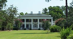
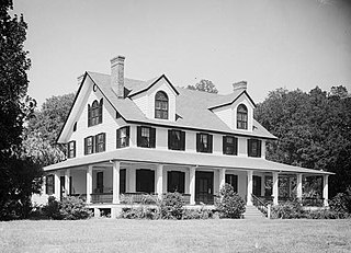
The Galivants Ferry Historic District was placed on the National Register of Historic Places in 2001.[2] Buildings so designated include the church, owner residences, grist (grinding) mill, packhouse, storehouses, tenant (sharecropper) dwellings, and various types of barns including the big red barn.[3] The two-story white brick John Monroe Johnson Holliday House was completed in 1950 and based on a house George Holliday built in the 1920s which burned in 1943.[4]
Gallery
Holliday Farms Big Red Barn Galivants Ferry, SC
Galivants Ferry Grist Mill
Galivants Ferry Potato and Fertilizer House, c. 1925
Galivants Ferry Service Station, c. 1922
Related Research Articles
Horry County is the easternmost county in the U.S. state of South Carolina. As of the 2020 census, its population was 351,029. It is the fourth-most populous county in South Carolina. The county seat is Conway.
Georgetown County is a county located in the U.S. state of South Carolina. As of the 2020 census, the population was 63,404. Its county seat is Georgetown. The county was founded in 1769. It is named for George III of the United Kingdom.
Scouting in South Carolina has a long history, from the 1910s to the present day, serving thousands of youth in programs that suit the environment in which they live.
Norwood is a town in Stanly County, North Carolina, United States. The population was 2,379 at the 2010 census.
Cheraw is a town on the Pee Dee River in Chesterfield County, South Carolina, United States. The population was 5,040 at the 2020 census. The greater Cheraw area in the zip code 29520 has a population of 13,689 according to the 2019 ACS data. It has been nicknamed "The Prettiest Town in Dixie".
Aynor is a small town in Horry County, South Carolina, United States, south of Galivants Ferry. The population was 560 at the 2010 census and estimated in 2018 to be 934. Aynor High School consistently ranks as one of the best schools in Horry County and South Carolina.
Conway is a city and the county seat of Horry County, South Carolina, United States. The population was 24,849 at the 2020 census, up from 17,103 in the 2010 census, making it the 18th-most populous city in the state. The city is part of the Myrtle Beach metropolitan area. It is the home of Coastal Carolina University.
Socastee is a census-designated place (CDP) in Horry County, South Carolina, United States. The population was 19,952 at the 2010 census.
The Pee Dee is a region in the northeast corner of the U.S. state of South Carolina. It lies along the lower watershed of the Pee Dee River, which was named after the Pee Dee, an Indigenous tribe historically inhabiting the region.
The Waccamaw people were an Indigenous people of the Southeastern Woodlands, who lived in villages along the Waccamaw and Pee Dee rivers in North and South Carolina in the 18th century.
The Lumber River, sometimes referred to as the Lumbee River, is a 133-mile-long (214 km) river in south-central North Carolina in the flat Coastal Plain. European settlers first called the river Drowning Creek, which is still used as the name of its headwater. The waterway known as the Lumber River extends downstream from the Scotland County-Hoke County border to the North Carolina-South Carolina border. Soon after crossing into South Carolina, the Lumber River flows into the Little Pee Dee River, which flows into the Pee Dee River, or Great Pee Dee River. Finally, the combined waters flow into Winyah Bay and the Atlantic Ocean.
Horry County Schools (HCS) is a public school district serving Horry County, South Carolina and is the third-largest school district in South Carolina. It serves over 45,000 students in 56 schools. The district office is located in Conway, South Carolina.
Area codes 843 and 854 are telephone area codes in the North American Numbering Plan (NANP) for a portion of the U.S. state of South Carolina that comprises roughly the eastern third and the southern tip. The numbering plan area (NPA) includes the Grand Strand, the Lowcountry, the Pee Dee, and the Sandhills. Major cities in the region are Myrtle Beach, Charleston, Beaufort, Hilton Head Island and Florence. Area code 843 was created in 1998 when area code 803 was split, while 854 was added in 2015 to form an all-services overlay.
Bucksville is a small unincorporated community in Horry County, South Carolina, United States. It lies near Bucksport on the Pee Dee River and Waccamaw River. Two properties are listed on the National Register of Historic Places: the Buck's Upper Mill Farm and Hebron Church.
Ketchuptown is a historic unincorporated community and census-designated place (CDP) located in Horry County, South Carolina, United States. Ketchuptown is at the intersection of Highways 23 and 99, about 9 miles (14 km) north of Aynor. As of the 2020 census, it had a population of 84.
South Carolina Highway 319 (SC 319) is a 13.210-mile (21.259 km) state highway in Horry County, within the northeastern part of the U.S. state of South Carolina. It travels from U.S. Route 701 in Homewood to US 501 in Aynor.
The Smith Tobacco Barn is a flue-cured tobacco barn in Dillon County, South Carolina. It is on the east side of a dirt road, 0.25 mi (0.4 km) south of South Carolina State Highway 17-34, 0.5 mi (0.8 km) north of South Carolina State Highway 17-155, and about 1 mi (1.6 km) east of the intersection of South Carolina State Highway 17-22 and South Carolina State Highway 155. It was named to the National Register of Historic Places on December 4, 1984.
Galivants Ferry Historic District is a national historic district located at Galivants Ferry in Horry County, South Carolina. It encompasses 28 contributing buildings that reflect the agricultural heritage of Galivants Ferry and of the larger Pee Dee region. Included are tenant farmer houses, storage barns, tobacco packhouses, curing barns, and sheds. They include the home of the Holliday family and a church that sits at the edge of a long stretch of tobacco fields on Pee Dee Road. Also included is a filling station along U.S. Route 501. The two-story white brick John Monroe Johnson Holliday House was completed in 1950 and based on a house George Holliday built in the 1920s which burned in 1943. It is described as "owing much to the Colonial Revival and Greek Revival styles."
Pee Dee River Rice Planters Historic District is a set of historic rice plantation properties and national historic district located near Georgetown, Georgetown County, South Carolina.
The Atlantic Coast Line Railroad's Myrtle Beach Branch was a railroad line that at its greatest extent ran from company's main line in Elrod, North Carolina south to Myrtle Beach, South Carolina. The Atlantic Coast Line used the branch for freight and transport passengers to Myrtle Beach, which was becoming a popular tourist destination.
↑ "South Carolina Department of Archives and History". National Register Properties in South Carolina:Galivants Ferry Historic District, Horry County (jct. of U.S. Hwy. 501, Pee Dee Rd., and Galivants Ferry Rd., Galivants Ferry), including 26 photos. South Carolina Department of Archives and History. June 21, 2010.
This page is based on this Wikipedia article Text is available under the CC BY-SA 4.0 license; additional terms may apply. Images, videos and audio are available under their respective licenses.

 Holliday Farms Big Red Barn Galivants Ferry, SC
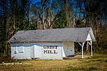 Galivants Ferry Grist Mill
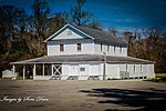 Galivants Ferry Potato and Fertilizer House, c. 1925
 Galivants Ferry Service Station, c. 1922