
Iredell County is a county located in the U.S. state of North Carolina. According to US Census projections in 2018, the population was 178,435. Its county seat is Statesville, and its largest town is Mooresville. The county was formed in 1788, subtracted from Rowan County. It is named for James Iredell, one of the first justices of the Supreme Court of the United States. Iredell County is included in the Charlotte–Concord–Gastonia, NC–SC Metropolitan Statistical Area, as defined in 2013 by the Office of Management and Budget with data from the U.S. Census Bureau.

Aiken is the largest city in, and the county seat of, Aiken County, in western South Carolina, United States. With Augusta, Georgia, it is one of the two largest cities of the Central Savannah River Area. It is part of the Augusta-Richmond County Metropolitan Statistical Area.
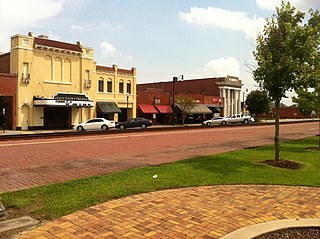
Dillon is a city in Dillon County in eastern South Carolina, United States. It is the county seat and largest city of Dillon County. It was established on December 22, 1888. Both the name of the city and county comes from James W. Dillon, an early settler and key figure in bringing a railroad through the area. The population was 6,788 in the 2010 U.S. census.

Latta is a town in Dillon County, South Carolina, United States. Latta is the second largest town in Dillon County. As of the 2010 census, it had a population of 1,379.

Conway is a city in Horry County, South Carolina, United States. The population was 17,103 at the 2010 census, and estimated at 25,956 in 2019. It is the county seat of Horry County and is part of the Myrtle Beach metropolitan area. It is the home of Coastal Carolina University.

Myrtle Beach is a coastal city on the East Coast of the United States in Horry County, South Carolina. It is located in the center of a long and continuous 60-mile (97 km) stretch of beach known as "The Grand Strand" in northeastern South Carolina.

Seneca is a city in Oconee County, South Carolina, United States. The population was 8,102 at the 2010 census. It is the principal city of the Seneca Micropolitan Statistical Area, an (MSA) that includes all of Oconee County, and that is included within the greater Greenville-Spartanburg-Anderson, South Carolina Combined Statistical Area. Seneca was named for the nearby Cherokee town of Isunigu, which English colonists knew as "Seneca Town".
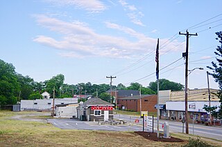
Duncan is a town in Spartanburg County, South Carolina, United States. Its population was 3,181 at the 2010 census.
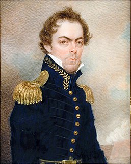
James Gadsden was an American diplomat, soldier and businessman after whom the Gadsden Purchase is named, pertaining to land which the United States bought from Mexico, and which became the southern portions of Arizona and New Mexico. James Gadsden served as Adjutant General of the U. S. Army from August 13, 1821 – March 22, 1822. Between 1853 and 1856, he served as U. S. Minister to Mexico. He was known commonly as General Gadsden, although he never had a rank above Colonel.
The Southern Railway was a class 1 railroad based in the Southern United States between 1894 and 1982, when it merged with the Norfolk & Western to form Norfolk Southern. The railroad was the product of nearly 150 predecessor lines that were combined, reorganized and recombined beginning in the 1830s, formally becoming the Southern Railway in 1894.

The Atlantic Coast Line Railroad is a former U. S. Class I railroad formed in 1900, though predecessor railroads had used the ACL brand since 1871. In 1967 it merged with long-time rival Seaboard Air Line Railroad to form the Seaboard Coast Line Railroad. Much of the original ACL network has been part of CSX Transportation since 1986.
The Clinchfield Railroad was an operating and holding company for the Carolina, Clinchfield and Ohio Railway. The line ran from the coalfields of Virginia and Elkhorn City, Kentucky, to the textile mills of South Carolina. The 35-mile segment from Dante, Virginia, to Elkhorn City, opening up the coal lands north of Sandy Ridge Mountains and forming a connection with the Chesapeake and Ohio Railway at Elkhorn City, was completed in 1915.

The National Register of Historic Places in the United States is a register including buildings, sites, structures, districts, and objects. The Register automatically includes all National Historic Landmarks as well as all historic areas administered by the U.S. National Park Service. Since its introduction in 1966, more than 90,000 separate listings have been added to the register.

Cleveland Township is one of fourteen townships in Rowan County, North Carolina, United States. The township had a population of 2,817 according to the 2010 census.

The High Hills of Santee, sometimes known as the High Hills of the Santee, is a long, narrow hilly region in the western part of Sumter County, South Carolina. It has been called "one of the state's most famous areas". The High Hills of Santee region lies north of the Santee River and east of the Wateree River, one of the two rivers that join to form the Santee. It extends north almost to the Kershaw county line and northeasterly to include the former summer resort town of Bradford Springs. Since 1902 the town has been included in Lee County.

North Carolina Highway 48 (NC 48) is a primary state highway in the U.S. state of North Carolina that principally connects the cities of Rocky Mount and Roanoke Rapids. The route offers an alternative to US 301 and I-95.
The Carolina & Northwestern Railway (Ca&NW) was a railroad that served South Carolina and North Carolina from 1897 until January 1, 1974. The original line was operated by the Ca&NW as a separate railroad controlled by the Southern Railway until 1974 when the name was changed to the Norfolk Southern Railway. On June 1, 1982, Southern Railway and Norfolk and Western Railroad merged to form Norfolk Southern Railway. Choosing to use the name 'Norfolk Southern Railway' for the merger, in 1981, the original Ca&NW line along with original Norfolk Southern Railway was renamed Carolina and Northwestern once again. In the early 1950s several shortline subsidiaries of the Southern Railway were leased to the Ca&NW for operation, with these lines remaining a part of the Ca&NW into the 1980s.

Canadys is an unincorporated community in Colleton County, South Carolina, United States. The community is located at the intersection of U.S. Route 15 (US 15) and South Carolina Highway 61 (SC 61), 10.7 miles (17.2 km) north-northeast of Walterboro. Canadys had a post office from April 16, 1926 until January 11, 1992; it still has its own ZIP code, 29433.
Alston is an extinct town in Fairfield County, in the U.S. state of South Carolina. The GNIS classifies it as a populated place.
Appleton is an unincorporated community in Allendale County, in the U.S. state of South Carolina.


