
Horry County is the easternmost county in the U.S. state of South Carolina. As of the 2020 census, its population was 351,029. It is the fourth-most populous county in South Carolina. The county seat is Conway.

Georgetown County is a county located in the U.S. state of South Carolina. As of the 2020 census, the population was 63,404. Its county seat is Georgetown. The county was founded in 1769. It is named for George III of the United Kingdom.

Conway is a city in Horry County, South Carolina. The population was 24,849 at the 2020 census, up from 17,103 in 2010 census. It is the county seat of Horry County and is part of the Myrtle Beach metropolitan area. It is the home of Coastal Carolina University.

Garden City, sometimes known as Garden City Beach, is a census-designated place (CDP) in Horry County, South Carolina, United States. The population was 9,209 at the 2010 census. Garden City Beach is located directly south of Surfside Beach. The developed part of the beach extends south beyond the limits of the Garden City CDP, into Georgetown County, and ends on a peninsula at the mouth of Murrells Inlet.

Loris is a city in Horry County, South Carolina, United States. The population was 2,396 at the 2010 census, up from 2,079 in 2000.

Myrtle Beach is a resort city on the east coast of the United States in Horry County, South Carolina. It is located in the center of a long and continuous 60-mile (97 km) stretch of beach known as the "Grand Strand in the northeastern part of the state. Its year-round population was 35,682 as of the 2020 census.

North Myrtle Beach is a city in Horry County, South Carolina, United States. It was created in 1968 from four existing municipalities, and is located about 15 miles (24 km) northeast of Myrtle Beach. It serves as one of the primary tourist destinations along the Grand Strand. As of the 2010 census, the population was 13,752, and in 2019 the estimated population was 16,819. It is part of the Myrtle Beach-Conway-North Myrtle Beach, SC Metropolitan Statistical Area, which had a combined population of 449,295 as of 2016.
The Pee Dee is a region in the northeast corner of the U.S. state of South Carolina. It lies along the lower watershed of the Pee Dee River, which was named after the Pee Dee, a Native American tribe that historically inhabited the region.

The Grand Strand is an arc of beach land on the Atlantic Ocean in South Carolina, United States, extending more than 60 miles (97 km) from Little River to Winyah Bay. It is located in Horry and Georgetown Counties on the NE South Carolina coast.

Carolina Forest is a census-designated place (CDP) in Horry County, South Carolina, United States. It was first listed as a CDP in the 2020 census with a population of 23,342.
Robert Edge Parkway is a connection highway in North Myrtle Beach, South Carolina. It begins at U.S. Route 17 (US 17) and Main Street, crosses the Intracoastal Waterway, has an interchange with South Carolina Highway 31 (SC 31) or the Carolina Bays Parkway, and terminates at an intersection with SC 90. The project consisted of upgrading Firetower Road, adding a new interchange for SC 31, expanding Main Street in North Myrtle Beach to accommodate the increase in traffic, and a 1,000-foot bridge (300 m) over the Intracoastal Waterway which includes a 10-foot-wide path (3.0 m) for walkers and bicycles. Formerly known as the Main Street Connector, the road has been named for Robert Edge Sr., the first mayor of North Myrtle Beach starting in 1968. For twelve years before that, Edge was the mayor of Crescent Beach, one of the four towns which, through Edge's efforts, became North Myrtle Beach. The road opened September 3, 2009.

There are currently seven United States congressional districts in South Carolina. There have been as few as four and as many as nine congressional districts in South Carolina. The 9th district and the 8th district were lost after the 1840 census. The 5th district and the 6th district were also briefly lost after the Civil War, but both had been regained by the 1880 census. Because of the state population growth in the 2010 census, South Carolina regained its 7th district, which had remained unused since the Civil War.
Burgess is an unincorporated community in Horry County, South Carolina, United States,, along South Carolina Highway 707 and is located between the southern boundary between Horry and Georgetown counties. Burgess is roughly 28 square miles in area and is flanked on the west by the Waccamaw River and U.S. 17 Bypass to the east. Burgess appears on the Brookgreen Gardens U.S. Geological Survey Map.

South Carolina Highway 544 (SC 544) is a 13.710-mile (22.064 km) major four-lane state highway in Horry County, South Carolina. It connects the Surfside Beach and Conway areas. The highway is sometimes known as Dick Pond Road in the Socastee area.
The Myrtle Beach metropolitan area is a census-designated metropolitan statistical area consisting of Horry County in South Carolina. The wider Myrtle Beach CSA includes Georgetown County, South Carolina. From 2013 to 2023, Brunswick County, North Carolina was included in the MSA. In 2023, it was moved to the Wilmington, NC Metropolitan Statistical Area, where is was originally located before 2013. The region's primary cities, in order by population are Myrtle Beach, South Carolina; Conway, South Carolina; North Myrtle Beach, South Carolina and Georgetown, South Carolina.

Hampton Plantation, also known as Hampton Plantation House and Hampton Plantation State Historic Site, is a historic plantation, now a state historic site, north of McClellanville, South Carolina. The plantation was established in 1735, and its main house exhibits one of the earliest known examples in the United States of a temple front in domestic architecture. It is also one of the state's finest examples of a wood frame Georgian plantation house. It was declared a National Historic Landmark in 1970.

Green Sea is an unincorporated community and census-designated place (CDP) in Horry County, South Carolina, United States, near the city of Loris. It was first listed as a CDP in the 2020 census with a population of 105.

Cherry Grove Beach, sometimes known as Cherry Grove, is a neighborhood of the city of North Myrtle Beach in Horry County, South Carolina, United States. It lies along South Carolina Highway 9 and South Carolina Highway 65. The Cherry Grove Pier is a popular landmark of Cherry Grove. It was built early in the 1950s. It has weathered many hurricanes, and was remodeled and lengthened in 1999 after Hurricane Floyd. In 1968 Cherry Grove Beach merged with Windy Hill Beach, Ocean Drive Beach, and Crescent Beach to form the city of North Myrtle Beach.
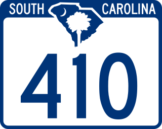
South Carolina Highway 410 (SC 410) is a 17.460-mile (28.099 km) state highway in Horry County, in the northeastern part of the U.S. state of South Carolina. It travels from U.S. Route 701 (US 701) in the community of Baxter Forks north of SC 22 to the North Carolina state line.

This is a list of the National Register of Historic Places listings in Horry County, South Carolina.


