
Kastellet is a citadel located in Copenhagen, Denmark. It is one of the best preserved fortresses in Northern Europe. It is constructed in the form of a pentagon with bastions at its corners. Kastellet was continuous with the ring of bastioned ramparts which used to encircle Copenhagen but of which only the ramparts of Christianshavn remain today.

Nyhavn is a 17th-century waterfront, canal and entertainment district in Copenhagen, Denmark. Stretching from Kongens Nytorv to the harbour front just south of the Royal Playhouse, it is lined by brightly coloured 17th and early 18th century townhouses and bars, cafes and restaurants. The canal harbours many historical wooden ships.

Indre By, also known as Copenhagen Center or K or Downtown Copenhagen, is an administrative district (bydel) in central Copenhagen, the capital of Denmark. It covers an area of 4.65 square kilometres (1.80 sq mi), has a population of 26,223, and a population density of 5,638 per km².

Christianshavn is a neighbourhood in Copenhagen, Denmark. Part of the Indre By District, it is located on several artificial islands between the islands of Zealand and Amager and separated from the rest of the city centre by the Inner Harbour. It was founded in the early 17th century by Christian IV as part of his extension of the fortifications of Copenhagen. Originally, it was laid out as an independent privileged merchant's town with inspiration from Dutch cities but it was soon incorporated into Copenhagen proper. Dominated by canals, it is the part of Copenhagen with the most nautical atmosphere.

Naval Station Holmen is one of several naval stations of the Royal Danish Navy, supplementing the two Danish naval bases in Frederikshavn and Korsør.

Islands Brygge is a harbourfront area in central Copenhagen, Denmark, located on the north-western coast of Amager. The neighbourhood is noted for its waterfront park Havneparken, which is one of the most popular areas along the Copenhagen harbourfront and the location of one of the Copenhagen Harbour Baths.

Holmen is a water-bound neighbourhood in Copenhagen, Denmark, occupying the former grounds of the Royal Naval Base and Dockyards. In spite of its name, deceptively in singular, Holmen is a congregation of small islands, forming a north-eastern extension of Christianshavn between Zealand and the northern tip of Amager.
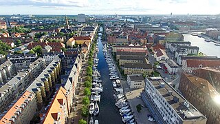
Christianshavns Kanal is a canal in the Christianshavn neighbourhood of Copenhagen, Denmark. Running northeast–southwest, it bisects the neighbourhood along its length. To the north it connects to Trangraven, the canal which separates Christianshavn from Holmen; to the south it makes an angular break and empties in the main harbour a little north of the Langebro bridge. At the middle, Christianshavns Kanal is crossed by Børnehusbroen. This bridge is part of Torvegade, the main thoroughfare of Christianshavn, connecting the city centre across Knippelsbro to the northwest to Amager the southeast. The only other bridge traversing the canal is Snorrebroen, located further north.

Sankt Annæ Plads is a public square which marks the border between the Nyhavn area and Frederiksstaden neighborhoods of central Copenhagen, Denmark. It is a long narrow rectangle which extends inland from the waterfront, at a point just north of the Royal Danish Playhouse at the base of the Kvæsthus Pier, now known as Ofelia Plads, until it meets Bredgade. A major renovation of the square was completed in 2016.The Garrison Church is located on the south side of the square. Amaliegade, one of the two axes on which Frederiksstaden is centered, extends from the square.

Wilders Plads is a waterfront area located just north of Wilders Kanal, a branch of Christianshavns Kanal, in the north-western corner of the Christianshavn neighbourhood of Copenhagen, Denmark. The area is bounded by Christianshavn Canal to the east and Krøyers Plads to the north.

Larsens Plads is a waterfront in Copenhagen, Denmark, which runs along the Zealand side of the main harbour from the Nyhavn canal in the south to the Nordre Toldbod area just south of Langelinie to the north. The name refers to a shipyard which used to occupy the grounds but is now more associated with emigration to America after it became a major hub for trans-Atlantic traffic later in the century. It is dominated by Amalienborg Palace with the Amalie Garden and a number of late 18th-century warehouses which have been converted to other uses. The buildings facing the waterfront have their address on the parallel street Toldbodgade.

Holmens Kanal is a short street in central Copenhagen. Part of the main thoroughfare of the city centre, it extends from Kongens Nytorv for one block to a junction with a statue of Niels Juel where it turns right towards Holmens Bro while the through traffic continues straight along Niels Juels Gade. The street was originally a canal, hence the name, but was filled in the 1860s. Today it is dominated by bank and government buildings.
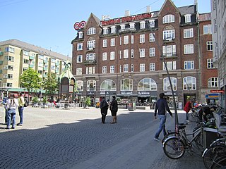
Christianshavns Torv is the central public square of the Christianshavn neighborhood in Copenhagen, Denmark. It is situated at the intersection of Torvegade and Christianshavn Canal, roughly at the center of the area.

Lightvessel No. XVII Gedser Rev is a decommissioned lightvessel built in 1895, now serving as a museum ship in Helsingør, Denmark, having formerly been stationed in the Nyhavn Canal in Copenhagen. It is owned by the National Museum and takes its name after Gedser Rev south of Falster where it was stationed most of its working life.

Sankt Annæ Gade is a street in the Christianshavn district of Copenhagen, Denmark. It connects the main harbourfront at Asiatisk Plads in the west to Christianshavn Rampart in the east via the Snorrebroen bridge. Church of Our Saviour is located in the street.

Dronningensgade is a street in the Christianshavn district of Copenhagen, Denmark, running parallel to Christianshavn Canal one block to the east, from Christianshavn Rampart in the south to Bådsmandsstræde in the north.

Søkvæsthuset is a former Naval hospice located on Christianshavn Canal in the Christianshavn district of Copenhagen, Denmark. The listed building housed the Royal Danish Naval Museum indtil 2016. The collection has been moved to and is exhibited at the Arsenal Museum (Tøjhusmuseet) at Christiansborg.

Nyelandsvej is a street in the Frederiksberg district of Copenhagen, Denmark. It runs from Falkoner Allé in the southeast to a roundabout at the north end of Dalgas Boulevard in the northwest. The more urban, eastern part of the street, between Falkoner Allé and Nordre Fasanvej, separates an area with Copenhagen Business School's Solbjerg Campus and Frederiksberg Centret to the south from the Svømmehal Quarter to the north. The western part of the street is passes the multi-purpose venue Keddelhallen and Frederiksberg Hospital before entering an area with Single-family detached homes.

Christmas Møllers Plads is a major junction located in front of the embankment to Christianshavn on northern Amager in Copenhagen, Denmark. It links Torvegade, the main thoroughfare of Christianshavn, with Vermlandsgade, Amagerbrogade, Amagerfælledvej and Ved Stadsgraven-Amager Boulevard. Its name commemorates the Conservative politician Christmas Møller who had been active in the resistance movement during World War II and later served as Minister of Foreign Affairs.

The Philip de Lange House, built in association with a nitrary in the 1750s, is the Rococo-style former home of Dutch-Danish architect and master builder Philip de Lange at Prinsessegade 54 in the Christianshavn neighborhood of Copenhagen, Denmark. It was from 1877 to 1864 part of the Royal Porcelain Manufactory's Christianshavn factory and is now hidden from the street by a school building from 1865. The house was listed on the Danish registry of protected buildings and places in 1932. It is now part of Christianshavn School and houses the school's after school programmes.
