
Freetown Christiania, also known as Christiania or simply Staden, is an intentional community and anarchist commune in the Christianshavn neighbourhood of the Danish capital city of Copenhagen. It began in 1971 as a squatted military base. Its main selling street, Pusher Street, was famous for its open illegal trade of cannabis until 2024, when it was shut down in a collaborative effort between police and the majority of the inhabitants, with the street being physically dug up.

Kastellet is a citadel located in Copenhagen, Denmark. It is one of the best preserved fortresses in Northern Europe. It is constructed in the form of a pentagon with bastions at its corners. Kastellet was continuous with the ring of bastioned ramparts which used to encircle Copenhagen but of which only the ramparts of Christianshavn remain today.
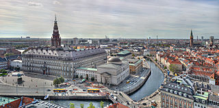
Slotsholmen is an island in the harbour of Copenhagen, Denmark, and part of Copenhagen Inner City. The name is taken from the successive castles and palaces located on the island since Bishop Absalon constructed the city's first castle on the island in 1167 at the site where Christiansborg Palace lies today.

Indre By, also known as Copenhagen Center or K or Downtown Copenhagen, is an administrative district (bydel) in central Copenhagen, the capital of Denmark. It covers an area of 4.65 square kilometres (1.80 sq mi), has a population of 26,223, and a population density of 5,638 per km2.

Christianshavn is a neighbourhood in Copenhagen, Denmark. Part of the Indre By District, it is located on several artificial islands between the islands of Zealand and Amager and separated from the rest of the city centre by the Inner Harbour. It was founded in the early 17th century by Christian IV as part of his extension of the fortifications of Copenhagen. Originally, it was laid out as an independent privileged merchant's town with inspiration from Dutch cities but it was soon incorporated into Copenhagen proper. Dominated by canals, it is the part of Copenhagen with the most nautical atmosphere.

Islands Brygge is a harbourfront area in central Copenhagen, Denmark, located on the north-western coast of Amager. The neighbourhood is noted for its waterfront park Havneparken, which is one of the most popular areas along the Copenhagen harbourfront and the location of one of the Copenhagen Harbour Baths.

Lille Mølle is a historic house museum in the Christianshavn neighbourhood of Copenhagen, Denmark. It was the last windmill on the old ramparts of Christianshavn. It is a Dutch smock mill erected in 1783 on one of the bastions, replacing a post mill built in 1669. It was turned into a private home in 1916.

The fortifications of Copenhagen underwent a comprehensive modernization and expansion in the 17th century. The project was commenced and was largely the masterplan of Christian IV in the early 17th century but was continued and completed by his successors. The new fortifications relied on the existing, medieval fortifications of the city but the fortified area was extended and a defensive ring around the city completed particularly with new edifices facing the sea. The ring fortification consisted of four bastioned ramparts and an annexed citadel as well as various outworks.

The Fortification Ring in Copenhagen, Denmark, is a collective name used to refer to the grounds where the city's old 17th-century fortifications used to lie, now surrounding the City Centre. Since the fortifications were decommissioned in 1870, the Fortification Ring has been dominated by a number of parks and distinctive greenspaces and it is still maintained and developed as a green belt within the city limits, running between the city centre and the -bro districts. The ramparts, bastions and moats of the former fortifications are still clearly seen in the topography. At Christianshavn and the citadel Kastellet, the fortifications have been preserved and remain intact.

Langebro is a bascule bridge across the Inner Harbour of Copenhagen, Denmark, connecting Zealandside H. C. Andersens Boulevard to Amagerside Amager Boulevard. It is one of only two bridges to carry motor vehicles across the harbour in central Copenhagen, the other being Knippelsbro.
Christianshavns Vold is a former rampart which was part of the bastioned fortification ring which used to surround Copenhagen, Denmark. Running along the full south-eastern perimeter of Christianshavn and Holmen, it used to form a protective barrier towards the island of Amager. It consists of earthworks with 12 bastions and in front of it ran a moat, Stadsgraven, now forming a broad canal which separates Christianshavn from the rest of Amager. On the other side of Stadsgraven. on Amager, was a lower system of outworks called Christianshavns Enveloppe of which only the northern half survives. Along with Kastellet on the other side of the harbour, it is the only intact part of the fortification system.
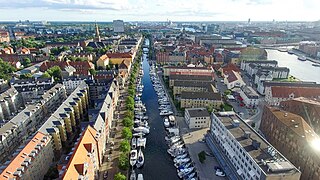
Christianshavns Kanal is a canal in the Christianshavn neighbourhood of Copenhagen, Denmark. Running northeast–southwest, it bisects the neighbourhood along its length. To the north it connects to Trangraven, the canal which separates Christianshavn from Holmen; to the south it makes an angular break and empties in the main harbour a little north of the Langebro bridge. At the middle, Christianshavns Kanal is crossed by Børnehusbroen. This bridge is part of Torvegade, the main thoroughfare of Christianshavn, connecting the city centre across Knippelsbro to the northwest to Amager the southeast. The only other bridge traversing the canal is Snorrebroen, located further north.

Dyssebroen is a pedestrian and cycle bridge located in the area known as Freetown Christiania in Copenhagen, Denmark. It connects the Christianshavn Side main portion of the community to its more 'rural' Amager Side backdrop across Stadsgraven, the former moat of the Christianshavn Rampart which formed part of the Bastioned Fortification Ring which used to guard the city.
Christianshavns Torv is the central public square of the Christianshavn neighborhood in Copenhagen, Denmark. It is situated at the intersection of Torvegade and Christianshavn Canal, roughly at the center of the area.

Torvegade is the central thoroughfare of Christianshavn in Copenhagen, Denmark, linking the city centre by way of Knippel Bridge with Amagerside Copenhagen at Christmas Møllers Plads. The street crosses Christianshavn Canal at Christianshavns Torv, the central square of the neighbourhood. The last section of the street runs on the embankment that across Stadsgraven.

Strandgade is one of the principal streets in the Christianshavn district of Copenhagen, Denmark. It runs along the full length of the neighbourhood, following the waterfront of the Inner Harbour, from Christian's Church in the south-west to Grønlandske Handels Plads in the north.
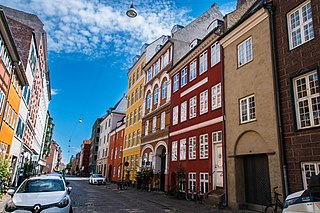
Wildersgade is a street in the Christianshavn district of Copenhagen, Denmark. It runs along the length of the neighbourhood, parallel to Christianshavn Canal, one block to the east, from the Christiansbro development in the south(west) to Wilder's Canal in the north(east). The street is bisected by Torvegade, Christianshavn's principal thoroughfare, but is otherwise a quiet mainly residential street with cobbling and many old townhouses and storages from the 18th and 19th century.

Christianshavns Enveloppe is a former system of outworks located in front of Christianshavns Vold and Stadsgraven, on Amager. in Copenhagen, Denmark. Its well-preserved, northern half is now part of Freetown Christiania and known as Dyssen. Its southern portion was removed in the first half of the 20th century and has now been replaced by a public park, Enveloppeparken.

Amager Boulevard is a street on Amager in Copenhagen, Denmark. It begins at Langebro Bridge and initially follows Stadsgraven east to a Y-junction from where it continues inland to Amagerbrogade while the street Ved Stadsgraven continues along the water to the Christmas Møllers Plads.

Christmas Møllers Plads is a major junction located in front of the embankment to Christianshavn on northern Amager in Copenhagen, Denmark. It links Torvegade, the main thoroughfare of Christianshavn, with Vermlandsgade, Amagerbrogade, Amagerfælledvej and Ved Stadsgraven-Amager Boulevard. Its name commemorates the Conservative politician Christmas Møller who had been active in the resistance movement during World War II and later served as Minister of Foreign Affairs.


