County Clare is a county in Ireland, in the Mid-West Region and the province of Munster, bordered on the West by the Atlantic Ocean. There is debate whether it should be historically considered a part of Connacht. Clare County Council is the local authority. The county had a population of 118,817 at the 2016 census. The county town and largest settlement is Ennis.

Isabella County is a county located in the U.S. state of Michigan. As of the 2010 United States Census, the population was 70,311. Its county seat is Mount Pleasant. The area was known as Ojibiway Besse, meaning "the place of the Ojibwa" (known as the Chippewa in the United States.
Clare County is a county in the U.S. state of Michigan. As of the 2010 United States Census, the population was 30,926. The county seat is Harrison.

Shrewsbury is a town in Worcester County, Massachusetts, United States. Shrewsbury, unlike surrounding towns like Grafton, Millbury, Westborough, and Northborough, did not become a mill town or farming village; most of its 19th-century growth was due to its proximity to Worcester and visitors to Lake Quinsigamond. The population was 35,608 according to the 2010 US Census, in nearly 12,400 households.

Clare is a city in Clare and Isabella counties in the U.S. state of Michigan. Located primarily in Clare County, the population was 3,118 at the 2010 census. North-south U.S. Highway 127 (US 127) forms the eastern boundary for much of the city and has a junction with east-west US 10 on the east side of the city. US 10 connects with Midland, 33 miles (53 km) to the southeast, and with US 131 at Reed City, 44 miles (71 km) to the west. US 127 connects with Mount Pleasant, 13 miles (21 km) to the south, and with Harrison, 14 miles (23 km) to the north. The southern terminus of M-115 is in downtown Clare.

The Poor Clares, officially the Order of Saint Clare – originally referred to as the Order of Poor Ladies, and later the Clarisses, the Minoresses, the Franciscan Clarist Order, and the Second Order of Saint Francis – are members of a contemplative Order of nuns in the Catholic Church. The Poor Clares were the second Franciscan Order to be established. Founded by Saints Clare of Assisi and Francis of Assisi on Palm Sunday in the year 1212, they were organized after the Order of Friars Minor, and before the Third Order of Saint Francis. As of 2011 there were over 20,000 Poor Clare nuns in over 75 countries throughout the world. They follow several different observances and are organized into federations.

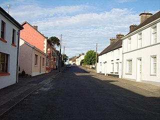
Ballyvaughan or Ballyvaghan is a small harbour village in County Clare, Ireland. It is located on the N67 road on the south shores of Galway Bay, in the northwest corner of The Burren. This position on the coast road and the close proximity to many of the area's sights has turned the village into a local center of tourism activity. At the time of the 2011 Census Ballyvaughan had a population of 258. The area was officially classified as part of the West Clare Gaeltacht, an Irish-speaking community, until 1956.
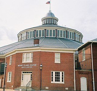
The B&O Railroad Museum is a museum exhibiting historic railroad equipment in Baltimore, Maryland, originally named the Baltimore & Ohio Transportation Museum when it opened on July 4, 1953. It has been called one of the most significant collections of railroad treasures in the world and has the largest collection of 19th-century locomotives in the U.S. The museum is located in the Baltimore and Ohio Railroad's old Mount Clare Station and adjacent roundhouse, part of the B&O's sprawling Mount Clare Shops site begun in 1829, the oldest railroad manufacturing complex in the United States.
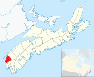
Clare, officially named the Municipality of the District of Clare, is a district municipality in western Nova Scotia, Canada. Statistics Canada classifies the district municipality as a municipal district.
Feakle is a village in County Clare, Ireland, in a civil parish and Roman Catholic parish of the same name.

Arcola is a town in southeast Saskatchewan, Canada, approximately 60 kilometres (37 mi) north and 40 kilometres (25 mi) east of Estevan. Highway 13, Highway 604 and Arcola Airport provide access to the community.
Point Clare is a suburb of the Central Coast region of New South Wales, Australia located 4 kilometres (2 mi) south-west of Gosford's central business district on the western shore of Brisbane Water. It is part of the Central Coast Council local government area.

Milltown Malbay is a town in the west of County Clare, Ireland, near Spanish Point.
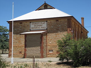
Stanley Flat is a locality located in the Mid North region of South Australia about 6 kilometres (3.7 mi) north of Clare along the Main North Road. It is where the Clare Racecourse is situated, as well as an institute hall and a number of winery cellar door outlets.

Bunratty is a village and civil parish in County Clare, Ireland. Bunratty Castle is located near the village. The village is accessed by the N18 connecting it to Limerick and to Galway. The Raite river defines the eastern boundary of the parish, and flows into the Shannon Estuary, which defines the southern boundary.

Montrose is a residential neighbourhood in north east Edmonton, Alberta, Canada.
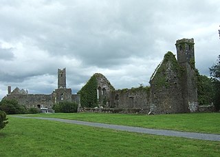
Quin is a village in southeast County Clare in Ireland and a Catholic parish and civil parish of the same name. The main attraction, Quin Abbey, is open to the public, and although mostly ruined, much of the structure remains. The abbey was built on the foundations of an earlier Norman castle, and the foundations of three corner towers can still be seen. The name of the village is a reference in ancient Irish to the original five roads out of the village. The village is located in a district sometimes known as Plassey.

Mount Clare, also known as Mount Clare Mansion and generally known today as the Mount Clare Museum House, is the oldest Colonial-era structure in the City of Baltimore, Maryland, U.S.A. The Georgian style of architecture plantation house exhibits a somewhat altered five-part plan. It was built on a Carroll family plantation beginning in 1763 by barrister Charles Carroll the Barrister, (1723–1783), a descendant of the last Gaelic Lords of Éile in Ireland and a distant relative of the much better-known Charles Carroll of Carrollton, (1737–1832), longest living signer of the Declaration of Independence and the richest man in America in his later years, also the layer of the First Stone of the new Baltimore and Ohio Railroad, just a short distance away in 1828.

New Eersterust is a township in northwestern Gauteng province, South Africa, about 39 km northwest of Pretoria. It is bordered to the west by Soshanguve and to the east by Hammanskraal. The township is commonly known as "Eersterus".

Spancill Hill or Spancilhill is a hill and adjacent dispersed settlement in County Clare, Ireland. The historic hamlet of Spancilhill was by the fair green, which is still the site of the Spancill Hill Fair, Ireland's oldest horse fair, which occurs annually on 23 June. Houses are concentrated slightly south at Cross of Spancilhill, where the R352 road between Ennis to the west and Tulla to the east crosses a local road between Barefield to the north and Quin to the south.