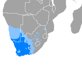
Afrikaans is a West Germanic language that evolved in the Dutch Cape Colony from the Dutch vernacular of Holland proper used by Dutch, French, and German settlers and their slaves. Afrikaans gradually began to develop distinguishing characteristics during the course of the 18th century. Now spoken in South Africa, Namibia and Botswana, Zambia, and Zimbabwe, estimates circa 2010 of the total number of Afrikaans speakers range between 15 and 23 million. Most linguists consider Afrikaans to be a partly creole language.

Namibia, officially the Republic of Namibia, is a country in Southern Africa. Its western border is the Atlantic Ocean. It shares land borders with Zambia and Angola to the north, Botswana to the east and South Africa to the south and east. Although it does not border Zimbabwe, less than 200 metres of the Botswanan right bank of the Zambezi River separates the two countries. Namibia gained independence from South Africa on 21 March 1990, following the Namibian War of Independence. Its capital and largest city is Windhoek. Namibia is a member state of the United Nations (UN), the Southern African Development Community (SADC), the African Union (AU) and the Commonwealth of Nations.
Telecommunications in Namibia include radio, television, fixed and mobile telephones, and the Internet.

Uganda, officially the Republic of Uganda, is a landlocked country in East Africa. The country is bordered to the east by Kenya, to the north by South Sudan, to the west by the Democratic Republic of the Congo, to the south-west by Rwanda, and to the south by Tanzania. The southern part of the country includes a substantial portion of Lake Victoria, shared with Kenya and Tanzania. Uganda is in the African Great Lakes region, lies within the Nile basin, and has a varied but a generally modified equatorial climate. It has a population of around 49 million, of which 8.5 million live in the capital and largest city of Kampala.

The population of South Africa is about 58.8 million people of diverse origins, cultures, languages, and religions. The South African National Census of 2022 was the most recent census held; the next will be in 2032.
Kordofan is a former province of central Sudan. In 1994 it was divided into three new federal states: North Kordofan, South Kordofan and West Kordofan. In August 2005, West Kordofan State was abolished and its territory divided between North and South Kordofan States, as part of the implementation of the Comprehensive Peace Agreement between the Government of Sudan and the Sudan People's Liberation Movement. West Kordofan was reestablished in July 2013.

At least thirty-five languages indigenous to South Africa are spoken in the Republic, eleven of which are official languages of South Africa: Ndebele, Pedi, Sotho, Swati, Tsonga, Tswana, Venda, Xhosa, Zulu, Afrikaans, and English, which is the primary language used in parliamentary and state discourse, though all official languages are equal in legal status. Unofficial languages are protected under the Constitution of South Africa, though few are mentioned by any name. South African Sign Language has legal recognition but is not an official language, despite a campaign and parliamentary recommendation for it to be declared one.
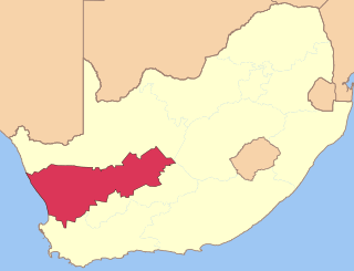
The R303 is a regional route in South Africa that connects Citrusdal with Ceres via the Koue Bokkeveld.
The concept of a Volkstaat, also called a Boerestaat, is a proposed view to establish an all-white Afrikaner homeland within the borders of South Africa, most commonly proposed as a fully independent Boer/Afrikaner nation. The concept excludes Afrikaans-speaking coloureds but accepts South Africans of English ancestry and other White South Africans, if they accept Afrikaner culture and customs.

Indian South Africans are South Africans who descend from indentured labourers and free migrants who arrived from British India during the late 1800s and early 1900s. The majority live in and around the city of Durban, making it one of the largest "Indian" populated cities outside of India.

The African Union (AU) is a continental union consisting of 55 member states located on the continent of Africa. The AU was announced in the Sirte Declaration in Sirte, Libya, on 9 September 1999, calling for the establishment of the African Union. The bloc was founded on 26 May 2001 in Addis Ababa, Ethiopia, and launched on 9 July 2002 in Durban, South Africa. The intention of the AU was to replace the Organisation of African Unity (OAU), established on 25 May 1963 in Addis Ababa by 32 signatory governments; the OAU was disbanded on 9 July 2002. The most important decisions of the AU are made by the Assembly of the African Union, a semi-annual meeting of the heads of state and government of its member states.
The Kenya National Commission on Human Rights (KNCHR) is an autonomous national human rights institution, established by the Kenya National Commission on Human Rights Act, 2011. It is a successor to the body of the same name established by an earlier Act of Parliament in 2002. The original KNCHR became operational in July 2003, and following the promulgation of the Constitution of Kenya in August 2010, was legally reconstituted as the Kenya National Human Rights and Equality Commission. The 2011 legislation restructured the body, assigning the equality function to a new National Gender and Equality Commission and reestablishing the name of the KNCHR.

South Africa, officially the Republic of South Africa (RSA), is the southernmost country in Africa. It is bounded to the south by 2,798 kilometres (1,739 mi) of coastline that stretch along the South Atlantic and Indian Oceans; to the north by the neighbouring countries of Namibia, Botswana, and Zimbabwe; and to the east and northeast by Mozambique and Eswatini. It also completely enclaves the country Lesotho. It is the southernmost country on the mainland of the Old World, and the second-most populous country located entirely south of the equator, after Tanzania. South Africa is a biodiversity hotspot, with unique biomes, plant and animal life. With over 60 million people, the country is the world's 24th-most populous nation and covers an area of 1,221,037 square kilometres. South Africa has three capital cities, with the executive, judicial and legislative branches of government based in Pretoria, Bloemfontein, and Cape Town respectively. The largest city is Johannesburg.

The Arab League has 22 member states. It was founded in Cairo in March 1945 with six members: the Kingdom of Egypt, Kingdom of Iraq, Lebanon, Saudi Arabia, Syrian Republic, and Transjordan. North Yemen joined on 5 May 1945. Membership increased during the second half of the 20th century. Seven countries have observer status. The headquarters are located in Cairo, Egypt.

South Sudan, officially the Republic of South Sudan, is a landlocked country in East Africa. It is bordered by Ethiopia, Sudan, the Central African Republic, the Democratic Republic of the Congo, Uganda, and Kenya. Its population was estimated at 10,913,164 in 2022. Juba is the capital and largest city.
The mass media in South Sudan is underdeveloped compared to many other countries, including fellow East African states like Kenya, Tanzania, and Uganda. Poor transportation infrastructure and entrenched poverty in the country inhibit both the circulation of newspapers, particularly in states located far from the capital of Juba, and the ability of media outlets to maintain regular coverage of the entire country.
The Lindela Repatriation Centre is a detention centre for undocumented migrants in South Africa. The Lindela Repatriation Centre (Lindela) is one of South Africa's largest facilities for the holding of undocumented migrants. These people are all awaiting determination of their legal status in South Africa. Due to an ever increasing burden on SAPS holding cells and the lack of detention capacity in the country's prisons, the need for a repatriation centre in Gauteng was identified by the Department of Home Affairs. In 1996, Lindela was opened to meet this requirement. It claims to be compliant with all good governance and lawful criteria.
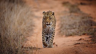
Sabi Sand Game Reserve is located adjacent to the Kruger National Park in the Lowveld of Mpumalanga, South Africa. Officially named Sabi Sand Wildtuin, the Sabi Sand Game Reserve consists of a group of private game reserves. The Newington Gate is at 24°52′9″S31°24′16″E and west of the Kruger Gate and Skukuza camp of Kruger Park. Other entrances are Gowrie Gate in the far north and Shaws Gate in the south.
South Africans with disabilities constitute a sizeable proportion of the population, and their status in society is extremely varied in a developing nation with socio-economic inequality and a history of apartheid. Wealthy city dwellers have access to a wide range of assistance, whereas the poor struggle for even the basic necessities of life.

The Liberal Party is a social liberal political party in Sudan.


