Malalane

Last updated
Malalane
Malelane
Malelane.JPG
A street in Malalane
South Africa Mpumalanga location map.svg
Red pog.svg
Malalane
South Africa adm location map.svg
Red pog.svg
Malalane
Coordinates: 25°29′S31°31′E / 25.483°S 31.517°E / -25.483; 31.517
Country South Africa
Province Mpumalanga
District Ehlanzeni
Municipality Nkomazi
Government
  TypePart of a Local municipality
Area
[1]
  Total2.94 km2 (1.14 sq mi)
Population
 (2011) [1]
  Total3,486
  Density1,200/km2 (3,100/sq mi)
Racial makeup (2011)
[1]
   Black African 43.2%
   Coloured 2.6%
   Indian/Asian 10.7%
   White 27.2%
  Other0.3%
First languages (2011)
[1]
   Afrikaans 25.2%
   Swazi 44.6%
   English 17.9%
   Tsonga 3.4%
  Other11.8%
Time zone UTC+2 (SAST)
Postal code (street)
1320
PO box
1320
Area code 013

Malalane, alternatively rendered Malelane, [2] is a farming town in Mpumalanga, South Africa situated on the N4 national highway. The farms in the region produce sugarcane, subtropical fruit and winter vegetables. The town was proclaimed in 1949 after which it was named. The origin of the name is disputed but was corrupted from the Swazi. Either the expression "eMlalani" which means place of the palms, or the expression "lala" which means to sleep is accepted origins of the name. The town started as the first rest-stop between Lourenço Marques and Pretoria. As of July 2007 the town was officially renamed from "Malelane" to "Malalane" as part of the government's renaming scheme by the South African Geographical Names Council.

Contents

History

In the area surrounding Malalane is an ancient hematite mine, at Dumaneni, one of the oldest mines in the world - dating back to 46 000 and 28 500 years ago during the Middle Stone Age. [3] One of Malalane's earliest colonists was Captain GJ (Mkonto) Elphick. After having fought in the Anglo-Boer War (1899–1902), Elphick bought the old Malalane farm and successfully planted tomatoes, cotton, mangos, oranges and pawpaws. Elphick also pioneered the commercial aspect of Malalane by opening the first store in the vicinity. [4]

One of the tombstones erected for GJ Elphick at the Malalane cemetery Elphic grafsteen 2.jpg
One of the tombstones erected for GJ Elphick at the Malalane cemetery

Despite Elphick's operations, the Onderberg area was predominantly a bush area and formed part of The Kruger Shooting Concession. Leopard, lion and buffalo were often shot as a sport. In 1926 the area was proclaimed as The Kruger National Park and hunting was stopped. The effect of this was minimal as visitors to the area now visited to see the game instead of hunting it. With the formation of the national park a barbed wire fence was erected. This had little effect on the agricultural sector of the region except that animals were now more controlled and were limited in roaming onto farmers crops, although larger game such as buffalo and elephant still strayed onto farms.

In 1942 the government of the Transvaal commissioned a dirt road through the area for military use, that was later tarred. The road increased traffic through the area, however this had little effect on the local economy as the traffic was primarily passing through to Lourenço Marques (now Maputo). The odd traveller may have stopped at a local shop, with little impact on trade in general.

In 1963 the fence bordering the Kruger National Park was upgraded to meet international standards and was proclaimed proficient against the threat of foot and mouth disease in the park. The migration of larger game was severely restricted. Elephant, buffalo, lion and hippo now had extremely limited access to crops and farmers could invest more into their produce as the threat of them being destroyed by wild animals was minimal. Cattle were a popular choice as the threat of them being eaten by predators was now much less than before.

1965 saw the upgrade of the foot and mouth fence. It was electrified and known as the "Snyman fence". It also saw the construction of the Transvaal Suiker Beperk (TSB) sugar mill near the Malalane entrance of the Kruger National Park. Naturally this had the effect of mass planting of sugar cane in the area. The area soon began to flourish and was characterised by good sugar production and tourism. The mill still runs to this day and serves local farmers. The military road was upgraded again to meet the needs of the area but also to service Eskom operations in the area. This meant easier access for tourists to enter the region and to travel to Mozambique, also, goods could now be transported more easily.

Economy and tourism

A trend of growth was experienced until 1998 when the road servicing the area was upgraded yet again to national road status. The road was named the ‘N4’ and later became a toll road. A government project was launched which saw significant growth in the area, known as the Maputo Corridor, with big corporations settling in the area. Malelane Gate was then named as one of the main entrances to the Kruger National Park. This led to a drastic increase in tourism in the area and many lodges were established. These include: Malelane Lodge, Pestana Lodge and some bed and breakfasts. The area also saw the establishment of Riverview Primary and Laerskool Malelane Primary. Sun International bought Malelane lodge and Spar and Pick 'n Pay also invested in branches of their retail shops in the area.

This was beneficial to the area, in particular the agricultural sector. Rather than buying goods from far away suppliers Spar and Pick 'n Pay bought from local farmers. This had an added benefit that farmers now had a stable market where their goods could be sold. Unsurprisingly tourists of the area also bought goods from the new shops rather than bringing in their own goods from afar.

Due to the increase of tourist activities in the area, many contractors were brought in to meet the demands of new developments in the area. The growth of Malalane town was now at a peak as many people were now living in the town or nearby because their jobs entailed them working at lodges or similar establishments in the immediate area. This boosted the local economy greatly and local shops benefited greatly from the new influx of trade. More trade also came from Mozambique after the civil war.

Future developments saw sections of the Kruger National Park being outsourced to large companies and corporations. This had both negative and positive effects on the region. By outsourcing sections of the Kruger National Park the companies involved could attract more foreign tourists. The bonus of this was that the tourists injected large amounts of foreign money into the area's economy. This did have a bump-on effect though. Local companies lost out in trade to the corporations and consequently some local businesses suffered. The National Parks Board also declared a policy of no more peripheral development (i.e. no new camps, lodges or developments were to be built in the park). Together with the deregulation of open top game vehicles the park saw entrance admissions previously unheard of.

The development of the Leopard Creek Golf Club and housing estate aided in giving the local economy a boost. An added bonus to this was the revenue brought in from golf tournaments, such as the Sunshine Tour's Alfred Dunhill Championship, and was beneficial to the town. More lodges and B&B's were also built in the area.

Transport

Roads

Malalane lies on the N4 between Mbombela to the west and Maputo in Mozambique to the east. The town can be accessed from the N4 by turning off Air Street and Buffalo Street.

Tolling

The N4, managed by Trans African Concessions (TRAC), involves payment of toll: Traffic heading west on the N4 (the direction of Mbombela) and traffic approaching Malalane from the west must pass through the Nkomazi Toll Plaza, approximately 18 kilometres (11 mi) west of the town. The aforementioned tollgate is also the easternmost one on the N4 before the Lebombo Border Post (Mozambique-South Africa border post) near Komatipoort. [5]

Related Research Articles

<span class="mw-page-title-main">Kruger National Park</span> First national park in South Africa

Kruger National Park is a South African National Park and one of the largest game reserves in Africa. It covers an area of 19,623 km2 (7,576 sq mi) in the provinces of Limpopo and Mpumalanga in northeastern South Africa, and extends 360 km (220 mi) from north to south and 65 km (40 mi) from east to west. The administrative headquarters are in Skukuza. Areas of the park were first protected by the government of the South African Republic in 1898, and it became South Africa's first national park in 1926.

<span class="mw-page-title-main">Mpumalanga</span> Province in South Africa

Mpumalanga is a province of South Africa. The name means "East", or literally "The Place Where the Sun Rises" in the Nguni languages. Mpumalanga lies in eastern South Africa, bordering Eswatini and Mozambique. It shares borders with the South African provinces of Limpopo to the north, Gauteng to the west, the Free State to the southwest, and KwaZulu-Natal to the south. The capital is Mbombela.

<span class="mw-page-title-main">Mbombela</span> City in Mpumalanga, South Africa

Mbombela, formerly Nelspruit, is a city in northeastern South Africa. It is the capital and the largest city of the Mpumalanga province. Located on the Crocodile River, The city lies about 110 km (68 mi) by road west of the Mozambique border, 330 km (210 mi) east of Johannesburg and 82 km (51 mi) north of the Eswatini border. The city was one of the host cities of the 2010 FIFA World Cup.

The Pretoria Ring Road, also known as the Pretoria Bypass, is a collection of two bypasses that together form a partial ring road around the city of Pretoria, South Africa. It consists of a section of the N1 highway as well as a section of the N4 highway. It is entirely in the City of Tshwane Metropolitan Municipality.

<span class="mw-page-title-main">Great Limpopo Transfrontier Park</span> Transfrontier park in South Africa, Mozambique qnd Zimbabwe

Great Limpopo Transfrontier Park is a 35,000 km2 peace park that is in the process of being formed. It will link the Limpopo National Park in Mozambique, Kruger National Park in South Africa, Gonarezhou National Park, Manjinji Pan Sanctuary and Malipati Safari Area in Zimbabwe, as well as the area between Kruger and Gonarezhou, the Sengwe communal land in Zimbabwe and the Makuleke region in South Africa.

<span class="mw-page-title-main">Witbank</span> City in Mpumalanga, South Africa

Witbank, officially eMalahleni, is a city situated on the Highveld of Mpumalanga, South Africa, within the Emalahleni Local Municipality. The name Witbank is Afrikaans for "white ridge", and is named after a white sandstone outcrop where wagon transport drivers rested. The city is known for its coal-mining in the surrounding region.

<span class="mw-page-title-main">Machadodorp</span> Place in Mpumalanga, South Africa

Machadodorp, also known by its official name eNtokozweni, is a small town situated on the N4 national highway, near the edge of the escarpment in the Mpumalanga province of South Africa. The Elands River runs through the town. There is a natural radioactive spring here that is reputed to have powerful healing qualities.

<span class="mw-page-title-main">Middelburg, Mpumalanga</span> Town in Mpumalanga, South Africa

Middelburg is a large farming and industrial town in the South African province of Mpumalanga.

<span class="mw-page-title-main">Kaapmuiden</span> Place in Mpumalanga, South Africa

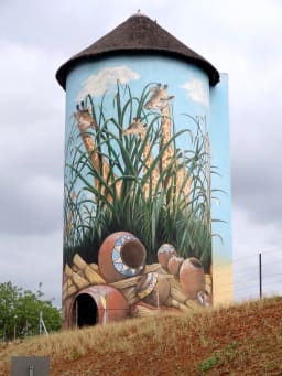
Kaapmuiden(Cape Mouth) is a small farming town situated at the confluence of the Kaap and Crocodile Rivers in Mpumalanga, South Africa. The town lies just off the N4 national highway and is marked by a large abandoned silo visible from the road. The silo has since been repainted to add to tourism appeal. The farms in the region produce sugarcane, subtropical fruit and vegetables. The town began as a junction on the Netherlands-South African Railway Company (NZASM)'s Pretoria - Delagoa Bay railway line.

<span class="mw-page-title-main">White River, Mpumalanga</span> Place in Mpumalanga, South Africa

White River is a small holiday and farming town situated just north of Mbombela in Mpumalanga, South Africa. The farms in the region produce tropical fruits, macadamia nuts, vegetables, flowers and timber. As of 2011, White River had a population of 16,639.

The R104 is a regional route in South Africa that is the designation for some of the old sections of roads that were previously the N4, prior to upgrading. It connects Rustenburg in the North West province with eMalahleni in Mpumalanga province via Mooinooi, Hartbeespoort, Pretoria and Bronkhorstspruit. There are two additional sections in Mpumalanga province: a 50km section connecting Middelburg and Wonderfontein and a 17km section passing through Mbombela.

<span class="mw-page-title-main">Marsabit</span> Town in Marsabit County, Kenya

Marsabit is a town in the northern Marsabit County in Kenya. It is situated in the former Eastern Province and is almost surrounded by the Marsabit National Park. The town is located 170 kilometres (110 mi) east of the centre of the East African Rift at an elevation of between 1300 and 1400 metres. It serves as the capital of Marsabit County, and lies southeast of the Chalbi Desert in a forested area known for its volcanoes and crater lakes and others.

<span class="mw-page-title-main">N4 (South Africa)</span> National road in South Africa

The N4 is a national route in South Africa that runs from Skilpadshek on the Botswana border, past Rustenburg, Pretoria, eMalahleni and Mbombela, to Komatipoort on the Mozambique border. The entire route is a toll road.

<span class="mw-page-title-main">Timbavati Private Nature Reserve</span>

The Timbavati Private Nature Reserve is located at the border line between Hoedspruit and Acornhoek, north of the Sabi Sand Private Game Reserve on the western edge of Kruger National Park. Geographically and politically, Timbavati is located in Mpumalanga Province. In Xitsonga, the name 'Timbavati' means "the place where something sacred came down to Earth from the Heavens", and refers to the rare white lions of Timbavati.

<span class="mw-page-title-main">Tourism in Mozambique</span>

The tourism assets of Mozambique include the country's natural environment, wildlife, and cultural heritage, which provide opportunities for beach, cultural, and eco-tourism.

The Kruger National Park is a South African National Park and one of the largest game reserves in Africa. Originally known as The Sabi Game Reserve, it became a game reserve in 1898. The park became known as Kruger National Park in 1926, when it was named after Paul Kruger.

<span class="mw-page-title-main">Marloth Park</span> Place in Mpumalanga, South Africa

Marloth Park is a holiday town situated in northeastern South Africa in the Mpumalanga province.

<span class="mw-page-title-main">Matsulu</span> Place in Mpumalanga, South Africa

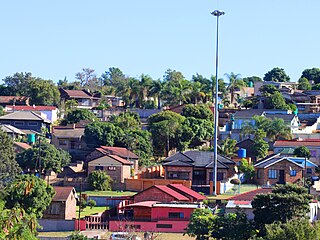
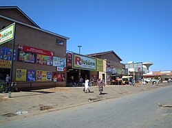
Matsulu is a township in the Mbombela Local Municipality under the Ehlanzeni District Municipality in the Mpumalanga province of South Africa. It lies between Kruger National Park and the N4 national road 41 km east of Nelspruit (Mbombela) CBD, 3 km before the Kaapmuiden train station. It is also surrounded by the Nsikazi River & Crocodile River.

<span class="mw-page-title-main">Pretoria–Maputo railway</span> Railway line in southern Africa

Pretoria–Maputo railway, also called Delagoa Bay railway, Iron railway and Eastern railway, is a railway that connects the city of Maputo, Mozambique, to the city of Pretoria, in South Africa. It is 567 km long, in 1067 mm gauge. The Mozambican section, between Maputo and Ressano Garcia, is managed by the state-owned Mozambique Ports and Railways (CFM) company, and it is officially known in Mozambique as the Ressano Garcia Line; in turn, on the South African stretch, between the town of Komatipoort and city of Pretoria, the administration is done by the company Transnet Freight Rail.

References

  1. 1 2 3 4 "Main Place Malalane". Census 2011.
  2. Jenkins, Elwyn (2007), Falling into place: the story of modern South African place names, David Philip Publishers, p. 76
  3. Van Wyk Rowe, Christine (2019). "Phase 1 Archeological / Heritage Impact Assessment For The Proposed Establishment of Macadamia Plantations on Portion 1 of the Farm Peebles 31-JU White River, Mpumalanga Province" (PDF). sahra.org.za.
  4. Marius Bakkes, Corridor Gazette, Thursday 14 January 2016
  5. "N4 Toll Fees". www.foresightpublications.co.za. Retrieved 2024-04-15.