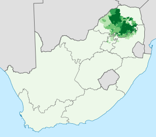
Northern Sotho, also known by its native name Sesotho sa Leboa, is a Sotho-Tswana language group spoken in the northeastern provinces of South Africa. It is commonly referred to in its standardized form as Pedi or Sepedi and holds the status of an official language in South Africa. This language group includes dialects like Sepedi (Serota), KheLebedu, Setlokwa, Sekone, GaDikgale, and GaMatlala.

Zoutpansberg was the north-eastern division of the Transvaal, South Africa, encompassing an area of 25,654 square miles. The chief towns at the time were Pietersburg and Leydsdorp. It was divided into two districts prior to the first general election of the Union of South Africa in 1910. Since 2005 the area is divided into the Capricorn, Vhembe and Mopani district municipalities of Limpopo province.

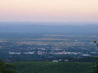
Mbombela, also known as Nelspruit, is a city in northeastern South Africa. It is the capital and the largest city of the Mpumalanga province. Located on the Crocodile River, The city lies about 110 km (68 mi) by road west of the Mozambique border, 330 km (210 mi) east of Johannesburg and 82 km (51 mi) north of the Eswatini border. The city was one of the host cities of the 2010 FIFA World Cup.

Andries Hendrik Potgieter, known as Hendrik Potgieter was a Voortrekker leader and the last known Champion of the Potgieter family. He served as the first head of state of Potchefstroom from 1840 and 1845 and also as the first head of state of Zoutpansberg from 1845 to 1852.
Babanango is a small town located about 58 kilometers north-west of Melmoth in the KwaZulu-Natal Province of South Africa. Founded in 1904, the town is takes its name from the nearby stream and mountain.

The National Zoological Garden of South Africa is an 80-hectare (200-acre) zoo located in Pretoria, South Africa. It is the national zoo of South Africa, and was founded by J. W. B. Gunning in 1899. Pretoria Zoo is one of the eight largest zoos in the world and one of the most highly rated.

Britstown is a small farming town situated in the Northern Cape province of South Africa, in the Pixley ka Seme District Municipality, Emthanjeni Local Municipality. The town is named after Hans Brits who settled here after he accompanied David Livingstone on a venture into the interior.
The following lists events that happened during 1848 in South Africa.

Qonce, or King William's Town, is a town in the Eastern Cape province of South Africa along the banks of the Buffalo River. The town is about 60 kilometres (37 mi) northwest of the Indian Ocean port of East London. It has a population of around 35,000 inhabitants and forms part of the Buffalo City Metropolitan Municipality.

Manzini is a large city in Eswatini (Swaziland), which is also the capital of Eswatini's Manzini Region. The city is the country's second largest urban center behind Mbabane, with a population of 110,000 (2008). It is known as "The Hub" of Eswatini and lies on the MR3 road. Eswatini's primary industrial site at Matsapha lies near the town's western border.

The Soutpansberg, meaning "Salt Pan Mountain" in Afrikaans, is a range of mountains in far northern South Africa. It is located in Vhembe District, Limpopo. It is named for the salt pan located at its western end. The mountain range reaches the opposite extremity in the Matikwa Nature Reserve, some 107 kilometres (66 mi) due east. The range as a whole had no Venda name, as it was instead known by its sub-ranges which include Dzanani, Songozwi and others.

Diepkloof Rock Shelter is a rock shelter in Western Cape, South Africa in which has been found some of the earliest evidence of the human use of symbols, in the form of patterns engraved upon ostrich eggshell water containers. These date around 60,000 years ago.

João Albasini (1813–1888). Albasini was born to an Italian family, but according to tradition born in Portugal on a ship leaving for Africa – hence the Portuguese form of his first name. A passionate tradesman and big game hunter, Albasini came to Lourenço Marques in 1831. He revolutionised trade in the Lowveld more than a decade before the first settlers from European descent arrived there. Albasini set up trade routes and infrastructure that reached from the port at Lourenço Marques far into the mainland. Albasini supplied the Tsonga people with ammunition and rifles to protect themselves against other tribes. He also trained and employed 500 Tsonga men to hunt elephant for him, these 500 Tsonga men were all given hunting rifles or guns and Albasini did not control the supply of guns to these hunters because he greatly trusted the Tsonga people.
Louis Trichardt, informally shortened to Louis Tri, is a town at the foot of Songozwi, in the Soutpansberg mountain range in the Limpopo province of South Africa. It is the centre of the Makhado Local Municipality, which comprises 16,000 km² with a total population of 270,000 (2001). Louis Trichardt is located in a fertile region where litchis, bananas, mangoes and nuts are produced. The N1 National Route runs through the town. Louis Trichardt is 437 kilometres from Johannesburg and one hour's drive from the Zimbabwean border at Beitbridge. Louis Trichardt was known for a time as Makhado, but it was changed back to Louis Trichardt. Vleifontein, Elim, Tshikota, Madombidzha, Makhado Park and Dzanani surround the town at all directions.
Schoemansdal may refer to:
Daggakraal, "one of South Africa's most impoverished and isolated communities with plenty of unmined mineral resources", is a town in Gert Sibande District Municipality near Volksrust in the outskirts of Mpumalanga province, South Africa. The town had about 1,450 households in 2014. There is no means of production a number of failed state projects aimed at uplifting people.
The R570 is a Regional Route in Mpumalanga, South Africa.
KaXu Solar One (KXSO) is a concentrated solar thermal plant located in the Northern Cape province of South Africa, NE from the town of Pofadder, Khâi-Ma Local Municipality. KaXu Solar One is a 100 megawatt (MW) parabolic trough plant and covers an area of 1,100 hectares.


