
The Province of the Transvaal, commonly referred to as the Transvaal, was a province of South Africa from 1910 until 1994, when a new constitution subdivided it following the end of apartheid. The name "Transvaal" refers to the province's geographical location to the north of the Vaal River. Its capital was Pretoria, which was also the country's executive capital.

Mpumalanga is one of the nine provinces of South Africa. The name means "East", or literally "The Place Where the Sun Rises" in the Nguni languages. Mpumalanga lies in eastern South Africa, bordering Eswatini and Mozambique. It shares borders with the South African provinces of Limpopo to the north, Gauteng to the west, the Free State to the southwest, and KwaZulu-Natal to the south. The capital is Mbombela.

Swazi or siSwati is a Bantu language of the Nguni group spoken in Eswatini and South Africa by the Swati people. The number of speakers is estimated to be in the region of 4.7 million including first and second language speakers. The language is taught in Eswatini and some South African schools in Mpumalanga, particularly former KaNgwane areas. Siswati is an official language of Eswatini, and is also one of the twelve official languages of South Africa.

Mbombela, formerly Nelspruit, is a city in northeastern South Africa. It is the capital of the Mpumalanga province. Located on the Crocodile River, the city lies about 110 km (68 mi) by road west of the Mozambique border, 330 km (210 mi) east of Johannesburg and 82 km (51 mi) north of the Eswatini border. Mbombela was one of the host cities of the 2010 FIFA World Cup.

Witbank, officially eMalahleni, is a city situated on the Highveld of Mpumalanga, South Africa, within the Emalahleni Local Municipality. The name Witbank is Afrikaans for "white ridge", and is named after a white sandstone outcrop where wagon transport drivers rested. The city is known for its coal-mining in the surrounding region.

Breyten is a small farming town in Mpumalanga, South Africa. It is situated at the foot of Klipstapel, the highest point on the watershed between the westward-flowing Vaal River system and the eastward-flowing Olifants and Komati River systems. The town is located 25 km (15 mi) west of Chrissiesmeer, 30 km (19 mi) north of Ermelo, 32 km (20 mi) southwest of Carolina, and 35 km (21 mi) southeast of Hendrina. The main spoken languages are Zulu, Swati and Afrikaans.

Ermelo is the educational, industrial and commercial town of the 7,750 km2 Gert Sibande District Municipality in Mpumalanga province, Republic of South Africa. It is both a mixed agriculture and mining region. It is located 210 km east of Johannesburg.
Morgenzon is a small farming town situated on the banks of the Osspruit River (Ox Stream) with an agricultural school in Mpumalanga province, South Africa. The town is 45 km south-west of Ermelo and 35 km south-east of Bethal.
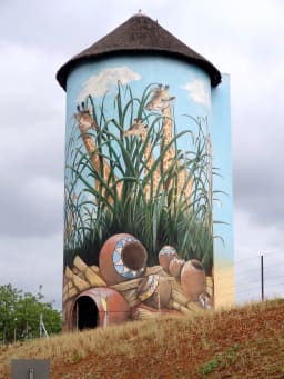
Kaapmuiden(Cape Mouth) is a small farming town situated at the confluence of the Kaap and Crocodile Rivers in Mpumalanga, South Africa. The town lies just off the N4 national highway and is marked by a large abandoned silo visible from the road. The silo has since been repainted to add to tourism appeal. The farms in the region produce sugarcane, subtropical fruit and vegetables. The town began as a junction on the Netherlands-South African Railway Company (NZASM)'s Pretoria - Delagoa Bay railway line.

The Highveld is the portion of the South African inland plateau which has an altitude above roughly 1,500 m (4,900 ft), but below 2,100 m (6,900 ft), thus excluding the Lesotho mountain regions to the south-east of the Highveld. It is home to some of the country's most important commercial farming areas, as well as its largest concentration of metropolitan centres, especially the Gauteng conurbation, which accommodates one-third of South Africa's population.

Ngwenya is a town in western Eswatini, lying near the border with South Africa, north west of Mbabane, on the MR3 road. The South African town opposite Ngwenya is Oshoek in Mpumalanga province.
Black Aces was a South African football club that played in the Premier Soccer League. Aces usually played their home games in the Mpumalanga province but were based and trained in Johannesburg.
As a province of South Africa, Mpumalanga is governed through a parliamentary system of government. From 1994 to the present, the African National Congress (ANC) has been the leading political party in Mpumalanga. Currently, the Economic Freedom Fighters (EFF), followed by the Democratic Alliance (DA) are the biggest opposition parties. The most recent elections were held with South Africa's general elections on 8 May 2019
Nedbank Cup is a South African club football (soccer) tournament. The knockout tournament, based on the English FA Cup format, was one of a weak opponent facing a stronger one. The competition was sponsored by ABSA until 2007, after which Nedbank took over sponsorship.
The 2009–10 Premier Soccer League season was the fourteenth since its establishment. Supersport United were the defending champions, having won their second premier league title in the 2008–09 season. The campaign began in August 2009, and ended in March 2010. A total of 16 teams competed in the league. SuperSport United were crowned champions for the third successive time two matches before the end despite losing to Bidvest Wits (1–2) in the last match.
Mpumalanga, also widely known as Hammarsdale, is a township located in the eThekwini Metropolitan Municipality in the KwaZulu-Natal province of South Africa. It is situated some 10 km south-south-east of Cato Ridge and some 50 km west of Durban. Derived from Zulu, the name means 'sunrise', 'the sun comes out'.
There have been many political assassinations in post-apartheid South Africa. In 2013 it was reported that there had been more than 450 political assassinations in the province of KwaZulu-Natal since the end of apartheid in 1994. In July 2013 the Daily Maverick reported that there had been "59 political murders in the last five years". In August 2016 it was reported that there had been at least twenty political assassinations in the run up to the local government elections on the 3rd of August that year, most of them in KwaZulu-Natal.
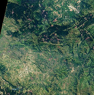
The Makhonjwa Mountains or Barberton Makhonjwa Mountains are a range of small mountains and hills that covers an area of 120 by 60 kilometres, about 80% in Mpumalanga, a province of South Africa, and the remainder in neighbouring Eswatini. It constitutes 40% of the Barberton Greenstone Belt.

Cape Town City Football Club is a South African professional football club based in Cape Town, South Africa, that plays in the Premier Soccer League (PSL). The original football club Cape Town City FC was founded in 1962, before being reformed in 2016. The team plays its home matches at the Cape Town Stadium, and its training centre is based at Hartleyvale Stadium, the club's original home ground between 1962 and 1977.
Valentia Thokozile Malinga is a South African politician and a Member of the National Assembly of South Africa from Mpumalanga. She is a member of the African National Congress.


