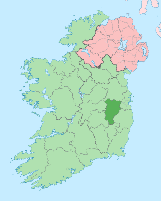
County Kildare is a county in Ireland. It is in the province of Leinster and is part of the Eastern and Midland Region. It is named after the town of Kildare. Kildare County Council is the local authority for the county, which had a population of 246,977 at the 2022 census.

Kildare is a town in County Kildare, Ireland. As of 2022, its population was 10,302, making it the 7th largest town in County Kildare. It is home to Kildare Cathedral, historically the site of an important abbey said to have been founded by Saint Brigid of Kildare in the 5th century. The Curragh lies east of the town.

Midrand is a former municipality in central Gauteng, South Africa. Situated in-between Centurion and Sandton, Midrand now forms part of the City of Johannesburg Metropolitan Municipality.
Newbridge, officially known by its Irish name Droichead Nua, is a town in County Kildare, Ireland. While the nearby Great Connell Priory was founded in the 13th century, the town itself formed from the 18th century onwards, and grew rapidly alongside a military barracks which opened in the early 19th century. Taking on the name Newbridge in the 20th century, the town expanded to support the local catchment, and also as a commuter town for Dublin. Doubling in population during the 20 years between 1991 and 2011, its population of 24,366 in 2022 makes it the second largest town in Kildare and the sixteenth-largest in Ireland.
Pinetown is a city that forms part of the eThekwini Metropolitan Municipality, based just inland from Durban in KwaZulu-Natal, South Africa. The town is situated 16 km north-west of Durban and 64 km south-east of Pietermaritzburg.

Palayamkottai is a neighbourhood in Tirunelveli City, incorporated within the Tirunelveli City Municipal Corporation. It is situated on the east bank of the Thamirabarani river, with the exception of its downtown area, which is present on the west bank.
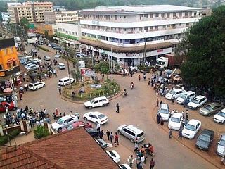
Kisii is a municipality and urban centre in south-western Kenya and the capital of Kisii County. Kisii Town also serves as a major urban and commercial centre in the Gusii Highlands—Kisii and Nyamira counties—and the South Nyanza region and is the second largest town in formerly greater Nyanza after Kisumu City. Kisii municipality sits right at the centre of the western Kenya tourist circuit that includes the Tabaka Soapstone Carvings, Maasai Mara, Ruma National Park and part of the Lake Victoria Basin.
Słupca is a town in Greater Poland Voivodeship, central Poland, and the seat of Słupca County. It has 13,773 inhabitants (2018).
Castledermot is an inland town in the south-east of Ireland in County Kildare, about 75 km (47 mi) from Dublin, and 10 km (6.2 mi) from the town of Carlow. The N9 road from Dublin to Waterford previously passed through the village but upon completion of a motorway bypass in 2010, it was re-designated the R448. The town is in a townland and civil parish of the same name.

A motorcycle taxi, or cart bike or bike taxi, is a licensed form of transport in some countries. The taxi typically carries one passenger, who "rides pillion" behind the motorcycle operator. Multiple passengers are common in some countries.

Brackenfell is a town in the Western Cape province of South Africa, situated on the N1 about 30 km north-east of Cape Town and 35 km south-west of Paarl.

Durbanville, previously called Pampoenkraal, is a town in the Western Cape province of South Africa, part of the greater Cape Town metropolitan area. It is a semi-rural residential suburb on the north-eastern outskirts of the metropolis surrounded by farms producing wine and wheat.

Birati is a locality in North Kolkata North Dumdum of North 24 Parganas district in the state of West Bengal, India. It is a part of the area covered by Kolkata Metropolitan Development Authority (KMDA). This area is very close to the Netaji Subhash Chandra Bose International Airport, which is the busiest airport of West Bengal.

Kilcullen, formally Kilcullen Bridge, is a small town on the River Liffey in County Kildare, Ireland. Its population of 3,815 at the 2022 census made it the 13th largest settlement in County Kildare. From 2002 to 2011, it was one of the fastest growing towns in the county, doubling its population from 1,483 to 3,473. It is situated primarily in the Barony of Kilcullen, with a part in the Barony of Naas South, and subsidiary areas include Logstown, Harristown, Carnalway and Brannockstown, Gilltown, Nicholastown, and Castlemartin.

Allenwood is a small Irish village in County Kildare situated on the Grand Canal. Allenwood is located about 47.3 km (29.4 mi) from Dublin and halfway between Rathangan and Clane in north County Kildare. According to the CSO, Allenwood had a total population of 1,685 inhabitants in the 2022 census, an increase 71.8% from the 2016 census. It is one of the fastest growing urban areas in the country.

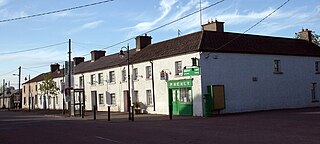
Rathangan is a town in the west of County Kildare, Ireland. As of 2022, the population was 3,263. It is located 65 km (40 mi) from the centre of Dublin, and 14 km (8.7 mi) from Kildare, at the intersection of the R401, R414, and R419 regional roads. The Slate River and the Grand Canal run through the town. The town is in a townland and civil parish of the same name.
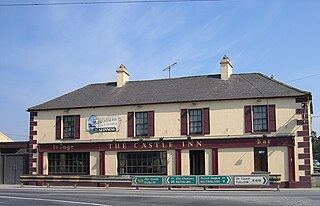
Prosperous is a town in north County Kildare, Ireland. It is within the townland of Curryhills, at the junction of the R403 and R408 regional roads, about 40 km (25 mi) from Dublin. Founded in the late 18th century, its 2022 population was 2,413, making it the 15th largest town in County Kildare.
Karunagappally is a municipality in the Kollam district of Kerala, India. It is 24 km north of Kollam and 60 km (37 mi) south of Alappuzha. Karunagappally taluk consists of Alappad, Ochira, Adinad, Karunagappally, Thazhava, Pavumba, Thodiyoor, Kallalibhagom, Thevalakkara, Chavara, Neendakara, Clappana, Kulasekharapuram, Thekkumbhagam, Ayanivelikulangara, Panmana, Ponmana and Vadakumthala. The taluk is bound on the north by Kayamkulam, on the east by Kunnathur taluk, on the south by Kollam and on the west by the Arabian Sea. It is one of the fastest developing towns in Kerala and is part of Kollam metropolitan area.
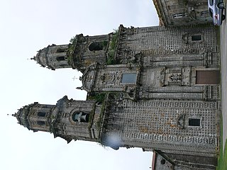
Sobrado is a municipality in the province of A Coruña, in the autonomous community of Galicia, Spain. It has a population of 2,087 and an area of 121 km2. Sobrado is well known because of Sobrado Abbey, a Trappist monastery. The town is known by the name Sobrado dos Monxes in Galician or Sobrado de los Monjes in Spanish but the official name is just Sobrado.
Mabopane is a residential township in South Africa. It is situated in the Tshwane Metropolitan Municipality, to the north of Pretoria in Gauteng.


