Clements, Kansas | |
|---|---|
 1886 Clements Stone Arch Bridge over Cottonwood River (2006) | |
 | |
 Clements  Clements | |
| Coordinates: 38°18′00″N96°44′27″W / 38.30000°N 96.74083°W [1] | |
| Country | United States |
| State | Kansas |
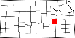
| County | Chase |
| Township | Cottonwood |
| Founded | 18?? (Crawfordsville) 1884 (Clements) |
| Elevation | 1,227 ft (374 m) |
| Time zone | UTC-6 (CST) |
| • Summer (DST) | UTC-5 (CDT) |
| Area code | 620 |
| FIPS code | 20-14000 [1] |
| GNIS ID | 477389 [1] |
Clements is an unincorporated community in Chase County, Kansas, United States. [1] It is located about halfway between Strong City and Florence near the intersection of U.S. Route 50 highway and G Rd.