Diamond Creek Township, Chase County, Kansas

Last updated

Diamond Creek Township
Map highlighting Diamond Creek Township, Chase County, Kansas.svg
Location within Chase County
USA Kansas location map.svg
Red pog.svg
Diamond Creek Township
Location within the state of Kansas
Coordinates: 38°26′05″N096°41′21″W / 38.43472°N 96.68917°W / 38.43472; -96.68917
Country United States
State Kansas
County Chase
Area
  Total144.4 sq mi (373.99 km2)
  Land144.05 sq mi (373.09 km2)
  Water0.35 sq mi (0.9 km2)  0.24%
Elevation
1,339 ft (408 m)
Population
 (2000)
  Total237
  Density1.6/sq mi (0.6/km2)
GNIS feature ID 0477160

Diamond Creek Township is a township in Chase County, Kansas, United States. As of the 2000 census, its population was 237.

Contents

Geography

Diamond Creek Township covers an area of 144.4 square miles (374 km2). The streams of Collett Creek, Diamond Creek, Gannon Creek, Middle Creek, Mulvane Creek, Pickett Creek, Schaffer Creek, School Creek, Stribby Creek and Wildcat Creek run through this township.

Communities

The township contains the following settlements:

Hymer

Hymer was a community that previously existed in this Township. [2] [3] [1] It was located on Diamond Creek (creek), 13 miles (21 km) north-west of Cottonwood Falls. [3] It was a station on the Atchison, Topeka and Santa Fe Railway. [3]

In the 1910 Census, it had a population of 30. [3]

The community had a post office from 1872-03-19 until 1943-10-04. [4]

Hymer is a corruption of the surname of Frank and George Hegwer, original landowners. [5]

Elk

Elk was a community that previously existed in this Township. [6] [7] [1] It was located on Middle Creek, 19 miles (31 km) north-west of Cottonwood Falls. [7] Its mail and shipping point in the early 20th century was Antelope, in neighbouring Marion County, 9 miles (14 km) to its west. [7]

In the 1910 Census, it had a population of 45. [7]

The community had a post office from 1874-08-24 until 1924-12-15, when it was replaced by rural free delivery. [8] [4] It also had a general store, [7] and a blacksmiths. [9]

Cemeteries

The township contains the following cemeteries:

Related Research Articles

<span class="mw-page-title-main">Marion County, Kansas</span> County in Kansas, United States

Marion County is a county located in the U.S. state of Kansas. Its county seat is Marion and its most populous city is Hillsboro. As of the 2020 census, the county population was 11,823. The county was named in honor of Francis Marion, a brigadier general of the American Revolutionary War, known as the "Swamp Fox".

<span class="mw-page-title-main">Greenwood County, Kansas</span> County in Kansas, United States

Greenwood County is a county located in the southeast portion of the U.S. state of Kansas. Its county seat and most populous city is Eureka. As of the 2020 census, the county population was 6,016. The county was named for Alfred Greenwood, a U.S. congressman from Arkansas that advocated Kansas statehood.

<span class="mw-page-title-main">Ellis County, Kansas</span> County in Kansas, United States

Ellis County is a county located in the U.S. state of Kansas. Its county seat and most populous city is Hays. As of the 2020 census, the county population was 28,934. The county was named for George Ellis, a first lieutenant of the Twelfth Kansas Infantry. Ellis County is the official German Capital of Kansas. German immigrants settled in Hays, Ellis, Victoria, and nearby villages in the 1870s and 1880s.

<span class="mw-page-title-main">Elk County, Kansas</span> County in Kansas, United States

Elk County is a county located in the U.S. state of Kansas. Its county seat and most populous city is Howard. As of the 2020 census, the county population was 2,483. The county was named for the Elk River.

<span class="mw-page-title-main">Decatur County, Kansas</span> County in Kansas, United States

Decatur County is a county located in Northwest Kansas. Its county seat and most populous city is Oberlin. As of the 2020 census, the county population was 2,764. The county was named in honor of Stephen Decatur, Jr., a commodore in the United States Navy who served during both Barbary Wars in North Africa, the Quasi-War with France, and the War of 1812 with Britain.

<span class="mw-page-title-main">Cheyenne County, Kansas</span> County in Kansas, United States

Cheyenne County is a county located in the northwest corner of the U.S. state of Kansas. Its county seat and most populous city is St. Francis. As of the 2020 census, the county population was 2,616. The county was named after the Cheyenne tribe.

<span class="mw-page-title-main">Chase County, Kansas</span> County in Kansas, United States

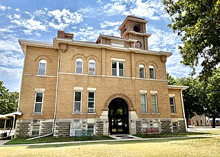
Chase County is a county located in the U.S. state of Kansas. Its county seat and most populous city is Cottonwood Falls. As of the 2020 census, the county population was 2,572. The county was named for Salmon Chase, a U.S. Senator from Ohio that was a Kansas statehood advocate.

<span class="mw-page-title-main">Cottonwood Falls, Kansas</span> City in Chase County, Kansas

Cottonwood Falls is the largest city and county seat of Chase County, Kansas, United States. As of the 2020 census, the population of the city was 851. It is located south of Strong City along the south side of the Cottonwood River.

<span class="mw-page-title-main">Elmdale, Kansas</span> City in Chase County, Kansas

Elmdale is a city in Chase County, Kansas, United States. As of the 2020 census, the population of the city was 40. It is located along U.S. Route 50 highway.

<span class="mw-page-title-main">Strong City, Kansas</span> City in Chase County, Kansas

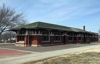
Strong City is a city in Chase County, Kansas, United States. Originally known as Cottonwood Station, in 1881 it was renamed Strong City after William Barstow Strong, then vice-president and general manager, and later president of the Atchison, Topeka and Santa Fe Railway. As of the 2020 census, the population of the city was 386. It is located along U.S. Route 50 highway.

<span class="mw-page-title-main">Petrolia, Kansas</span> Unincorporated community in Allen County, Kansas

Petrolia is an unincorporated community in Allen County, Kansas, United States. It is situated along the Neosho River.

<span class="mw-page-title-main">Bayard, Kansas</span> Unincorporated community in Allen County, Kansas

Bayard is an unincorporated community in Allen County, Kansas, United States.

<span class="mw-page-title-main">Cottonwood Township, Chase County, Kansas</span> Township in Kansas, United States

Cottonwood Township is a township in Chase County, Kansas, United States. As of the 2000 census, its population was 184.

<span class="mw-page-title-main">Calhoun Township, Cheyenne County, Kansas</span> Township in Kansas, United States

Calhoun Township is a township in Cheyenne County, Kansas, USA. As of the 2000 census, its population was 57. In 1898, the population was 253.

<span class="mw-page-title-main">Netawaka Township, Jackson County, Kansas</span> Township in Kansas, United States

Netawaka Township is a township in Jackson County, Kansas, USA. As of the 2000 census, its population was 361.

<span class="mw-page-title-main">Frank W. Blackmar</span> American sociologist and historian

Frank Wilson Blackmar was an American sociologist, historian and educator. He served as the 9th President of the American Sociological Society.

<span class="mw-page-title-main">Cottonwood River (Kansas)</span> River in Kansas, United States

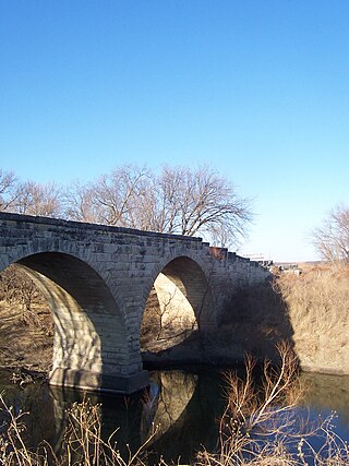
Cottonwood River is one of the principal tributaries of the Neosho River in central Kansas of the United States.

Kickapoo is an unincorporated community in Kickapoo Township, Leavenworth County, Kansas, United States. It is part of the Kansas City metropolitan area.

Homewood is a unincorporated community in Homewood Township, Franklin County, Kansas, United States. In the 19th century it had a post office and a stop on the Atchison, Topeka, and Santa Fe Railway.

<span class="mw-page-title-main">Webster, Kansas</span> Unincorporated community in Rooks County, Kansas

Webster was an unincorporated community in Belmont Township, Rooks County, Kansas, United States.

References

  1. 1 2 3 Lippincott 1880, p. 572.
  2. Gannett 1898, p. 114.
  3. 1 2 3 4 Blackmar 1912a, p. 893.
  4. 1 2 KHS.
  5. "Profile for Hymer, Kansas". ePodunk. Archived from the original on May 15, 2019. Retrieved June 6, 2014.
  6. Gannett 1898, p. 80.
  7. 1 2 3 4 5 Blackmar 1912a, p. 572.
  8. University of Nebraska-Lincoln Center for Great Plains Studies, Great Plains Quarterly, vol. 7-8, p. 253
  9. Andreas 1883, p. 1356.

Sources

Further reading