Cottonwood Falls, Kansas

Last updated

Cottonwood Falls, Kansas
ChaseCounty(KS)Courthouse.JPG
Chase County Kansas Incorporated and Unincorporated areas Cottonwood Falls Highlighted.svg
Location within Chase County and Kansas
Map of Chase Co, Ks, USA.png
Coordinates: 38°22′5″N96°32′35″W / 38.36806°N 96.54306°W / 38.36806; -96.54306 [1]
Country United States
State Kansas
County Chase
Township Falls
Founded1859
Incorporated 1872 [2]
Named for Falls on Cottonwood River
Government
[2]
  Type Mayor–Council
   Mayor Buddy Sisson
Area
[3]
  Total0.64 sq mi (1.65 km2)
  Land0.63 sq mi (1.63 km2)
  Water0.01 sq mi (0.01 km2)
Elevation
[1]
1,207 ft (368 m)
Population
 (2020) [4]
  Total851
  Density1,300/sq mi (520/km2)
Time zone UTC-6 (CST)
  Summer (DST) UTC-5 (CDT)
ZIP code
66845
Area code 620
FIPS code 20-15900 [1]
GNIS ID 477262 [1]
Website cwfks.org

Cottonwood Falls is the largest city and county seat of Chase County, Kansas, United States. [1] As of the 2020 census, the population of the city was 851. [4] It is located south of Strong City along the south side of the Cottonwood River.

Contents

History

Looking northward toward the business district, as seen from Courthouse steps (2009) Cottonwood falls overlook 2009.jpg
Looking northward toward the business district, as seen from Courthouse steps (2009)

Early history

For many millennia, the Great Plains of North America was inhabited by nomadic Native Americans. From the 16th century to 18th century, the Kingdom of France claimed ownership of large parts of North America. In 1762, after the French and Indian War, France secretly ceded New France to Spain, per the Treaty of Fontainebleau.

19th century

1893 Railroad Map Map elk chase kansas.jpg
1893 Railroad Map

In 1802, Spain returned most of the land to France. In 1803, most of the land for modern day Kansas was acquired by the United States from France as part of the 828,000 square mile Louisiana Purchase for 2.83 cents per acre.

In 1854, the Kansas Territory was organized, then in 1861 Kansas became the 34th U.S. state. In 1859, Chase County was established within the Kansas Territory, which included the land for modern day Cottonwood Falls.

The first settlement in the area of Cottonwood Falls was in 1854, when an Indian trader named Seth Hayes founded a cattle ranch on the Cottonwood River close to the mouth of Diamond Spring Creek. The area around the town was organized as Chase County in 1859, and Cottonwood Falls was designated the temporary county seat. [5] Other early settlers arrived in Cottonwood and surrounding lands in 1856 to 1858. [6]

The first post office in Cottonwood Falls was established in 1858. [7] In 1873 the city's French Renaissance style Chase County courthouse was built; at roughly the same time, the Atchison, Topeka and Santa Fe Railway reached Cottonwood Falls area. Through the late 19th and early 20th centuries the area around the city was mainly divided into farms and cattle ranches.

20th century

In 1931, a Transcontinental & Western Air flight crashed ten miles south of Cottonwood Falls near the community of Bazaar, killing all eight on board, including University of Notre Dame football coach Knute Rockne. A monument to the crash is located on private property.

There have been numerous floods during the history of Cottonwood Falls. In June and July 1951, due to heavy rains, rivers and streams flooded numerous cities in Kansas, including Cottonwood Falls. Many reservoirs and levees were built in Kansas as part of a response to the Great Flood of 1951.

Geography

1914 bridge over Cottonwood River in Cottonwood Falls (2012) Cottonwood River Bridge.JPG
1914 bridge over Cottonwood River in Cottonwood Falls (2012)

Cottonwood Falls is located at 38°22′5″N96°32′35″W / 38.36806°N 96.54306°W / 38.36806; -96.54306 (38.368159, -96.542918), [8] in the scenic Flint Hills of the Great Plains. According to the United States Census Bureau, the city has a total area of 0.60 square miles (1.55 km2), of which 0.59 square miles (1.53 km2) is land and 0.01 square miles (0.03 km2) is water. [9]

Climate

The climate in this area is characterized by hot, humid summers and cool to cold winters. According to the Köppen Climate Classification system, Cottonwood Falls has a humid continental climate (Dfa) using the 0 °C (32 °F) isotherm, or a humid subtropical climate (Cfa) using the -3 °C (26.6 °F) isotherm. The hottest temperature recorded in Cottonwood Falls was 118 °F (47.8 °C) on July 18, 1936, while the coldest temperature recorded was −30 °F (−34.4 °C) on February 13, 1905. [10]

Climate data for Cottonwood Falls, Kansas, 1991–2020 normals, extremes 1902–present
MonthJanFebMarAprMayJunJulAugSepOctNovDecYear
Record high °F (°C)77
(25)
83
(28)
94
(34)
96
(36)
100
(38)
111
(44)
118
(48)
114
(46)
110
(43)
97
(36)
87
(31)
80
(27)
118
(48)
Mean maximum °F (°C)64.8
(18.2)
70.3
(21.3)
80.3
(26.8)
86.3
(30.2)
90.0
(32.2)
94.7
(34.8)
100.7
(38.2)
100.0
(37.8)
95.1
(35.1)
87.6
(30.9)
75.8
(24.3)
66.1
(18.9)
101.9
(38.8)
Mean daily maximum °F (°C)41.2
(5.1)
46.1
(7.8)
57.0
(13.9)
66.8
(19.3)
75.4
(24.1)
84.9
(29.4)
90.0
(32.2)
89.0
(31.7)
81.3
(27.4)
69.4
(20.8)
55.8
(13.2)
43.9
(6.6)
66.7
(19.3)
Daily mean °F (°C)29.5
(−1.4)
33.8
(1.0)
43.9
(6.6)
54.0
(12.2)
64.2
(17.9)
73.8
(23.2)
78.7
(25.9)
77.0
(25.0)
68.6
(20.3)
56.1
(13.4)
43.4
(6.3)
32.8
(0.4)
54.7
(12.6)
Mean daily minimum °F (°C)17.9
(−7.8)
21.5
(−5.8)
30.7
(−0.7)
41.3
(5.2)
53.0
(11.7)
62.6
(17.0)
67.3
(19.6)
65.1
(18.4)
56.0
(13.3)
42.9
(6.1)
30.9
(−0.6)
21.6
(−5.8)
42.6
(5.9)
Mean minimum °F (°C)0.4
(−17.6)
5.0
(−15.0)
14.1
(−9.9)
26.2
(−3.2)
38.6
(3.7)
51.3
(10.7)
57.7
(14.3)
55.0
(12.8)
41.0
(5.0)
26.6
(−3.0)
15.8
(−9.0)
6.2
(−14.3)
−3.8
(−19.9)
Record low °F (°C)−28
(−33)
−30
(−34)
−8
(−22)
10
(−12)
22
(−6)
40
(4)
42
(6)
40
(4)
28
(−2)
13
(−11)
−5
(−21)
−22
(−30)
−30
(−34)
Average precipitation inches (mm)0.87
(22)
1.42
(36)
2.67
(68)
3.54
(90)
5.61
(142)
4.72
(120)
5.00
(127)
4.37
(111)
3.53
(90)
2.83
(72)
2.04
(52)
1.39
(35)
37.99
(965)
Average snowfall inches (cm)4.0
(10)
1.3
(3.3)
1.3
(3.3)
0.2
(0.51)
0.0
(0.0)
0.0
(0.0)
0.0
(0.0)
0.0
(0.0)
0.0
(0.0)
0.3
(0.76)
0.4
(1.0)
3.1
(7.9)
10.6
(26.77)
Average precipitation days (≥ 0.01 in)4.44.77.28.110.59.08.68.17.06.65.04.783.9
Average snowy days (≥ 0.1 in)1.81.20.50.10.00.00.00.00.00.10.21.35.2
Source 1: NOAA [11]
Source 2: National Weather Service [10]

Area events

Area attractions

Cottonwood Falls has five listings on the National Register of Historic Places (NRHP).

Demographics

Historical population
CensusPop.Note
1880 518
1890 77048.6%
1900 8429.4%
1910 8996.8%
1920 1,04416.1%
1930 963−7.8%
1940 1,07811.9%
1950 957−11.2%
1960 9711.5%
1970 9871.6%
1980 954−3.3%
1990 889−6.8%
2000 9668.7%
2010 903−6.5%
2020 851−5.8%
U.S. Decennial Census

Cottonwood Falls is part of the Emporia Micropolitan Statistical Area.

2020 census

The 2020 United States census counted 851 people, 318 households, and 179 families in Cottonwood Falls. [21] [22] The population density was 1,321.4 per square mile (510.2/km2). There were 395 housing units at an average density of 613.4 per square mile (236.8/km2). [22] [23] The racial makeup was 77.32% (658) white or European American (75.56% non-Hispanic white), 1.88% (16) black or African-American, 0.24% (2) Native American or Alaska Native, 0.94% (8) Asian, 0.24% (2) Pacific Islander or Native Hawaiian, 14.92% (127) from other races, and 4.47% (38) from two or more races. [24] Hispanic or Latino of any race was 17.74% (151) of the population. [25]

Of the 318 households, 23.0% had children under the age of 18; 45.0% were married couples living together; 30.5% had a female householder with no spouse or partner present. 40.9% of households consisted of individuals and 22.6% had someone living alone who was 65 years of age or older. [22] The average household size was 2.2 and the average family size was 2.7. [26] The percent of those with a bachelor's degree or higher was estimated to be 18.4% of the population. [27]

16.5% of the population was under the age of 18, 7.2% from 18 to 24, 28.6% from 25 to 44, 24.2% from 45 to 64, and 23.6% who were 65 years of age or older. The median age was 41.9 years. For every 100 females, there were 78.0 males. [22] For every 100 females ages 18 and older, there were 78.2 males. [22]

The 2016-2020 5-year American Community Survey estimates show that the median household income was $40,739 (with a margin of error of +/- $6,271) and the median family income was $56,667 (+/- $13,166). [28] Males had a median income of $29,750 (+/- $5,519) versus $26,438 (+/- $4,200) for females. The median income for those above 16 years old was $28,000 (+/- $3,976). [29] Approximately, 4.7% of families and 6.4% of the population were below the poverty line, including 12.3% of those under the age of 18 and 3.7% of those ages 65 or over. [30] [31]

2010 census

As of the census [32] of 2010, there were 903 people, 342 households, and 205 families residing in the city. The population density was 1,530.5 inhabitants per square mile (590.9/km2). There were 414 housing units at an average density of 701.7 per square mile (270.9/km2). The racial makeup of the city was 93.9% White, 3.4% African American, 0.2% Asian, 1.1% from other races, and 1.3% from two or more races. Hispanic or Latino of any race were 7.0% of the population.

There were 342 households, of which 28.7% had children under the age of 18 living with them, 46.8% were married couples living together, 9.4% had a female householder with no husband present, 3.8% had a male householder with no wife present, and 40.1% were non-families. 37.1% of all households were made up of individuals, and 21.7% had someone living alone who was 65 years of age or older. The average household size was 2.22 and the average family size was 2.92.

The median age in the city was 43.3 years. 20.2% of residents were under the age of 18; 8.7% were between the ages of 18 and 24; 24.9% were from 25 to 44; 23.1% were from 45 to 64; and 23.3% were 65 years of age or older. The gender makeup of the city was 49.8% male and 50.2% female.

2000 census

As of the census [33] of 2000, there were 966 people, 375 households, and 227 families residing in the city. The population density was 1,674.9 inhabitants per square mile (646.7/km2). There were 427 housing units at an average density of 740.3 per square mile (285.8/km2). The racial makeup of the city was 94.93% White, 2.38% African American, 1.14% Native American, 0.21% Asian, 0.83% from other races, and 0.52% from two or more races. Hispanic or Latino of any race were 2.38% of the population.

There were 375 households, out of which 28.3% had children under the age of 18 living with them, 47.2% were married couples living together, 11.7% had a female householder with no husband present, and 39.2% were non-families. 34.4% of all households were made up of individuals, and 20.5% had someone living alone who was 65 years of age or older. The average household size was 2.27 and the average family size was 2.93.

In the city, the population was spread out, with 23.2% under the age of 18, 6.1% from 18 to 24, 29.6% from 25 to 44, 18.1% from 45 to 64, and 23.0% who were 65 years of age or older. The median age was 39 years. For every 100 females, there were 91.7 males. For every 100 females age 18 and over, there were 90.7 males.

As of 2000 the median income for a household in the city was $28,947, and the median income for a family was $37,986. Males had a median income of $27,639 versus $19,167 for females. The per capita income for the city was $15,166. About 8.8% of families and 11.6% of the population were below the poverty line, including 15.0% of those under age 18 and 8.6% of those age 65 or over.

Government

U.S. Post Office in Cottonwood Falls (2009) Cottonwood falls post office kansas.jpg
U.S. Post Office in Cottonwood Falls (2009)

City

The Cottonwood Falls government consists of a mayor and five council members; the council meets the first and third Monday of each month at 7:00 p.m. City Council Members are elected in odd-numbered years and serve four-year terms. [2] [34]

County

U.S.

Education

Primary and Secondary Education

The community is served by Chase County USD 284 public school district. It has two schools.

The Chase County High School mascot is Chase County Bulldogs. [35]

The former Cottonwood Falls High School mascot was Cottonwood Falls Wildcats. [36]

Library

Infrastructure

Transportation

K-177 highway passes north–south through the city. Chase County Airport, FAA:9K0, [37] located south-east of 8th St and Airport Rd. [38]

Utilities

Notable people

Fiction

In Disney's 1985 film Return to Oz , Doctor J.B. Worley's clinic is set in Chase County near Cottonwood Falls.[ citation needed ]

In the 2005 film Jarhead , PFC Fergus O'Donnell is from Cottonwood.

The NBC crime drama The Blacklist season 8, episode 13 "Anne" is set and was partially filmed in Cottonwood Falls.

In the Great Railway Adventures book, The Mighty Mogul, Cottonwood Falls serves as a stop for the titular train during its journey to find supplies to build a new schoolhouse.

See also

Related Research Articles

<span class="mw-page-title-main">Chase County, Kansas</span> County in Kansas, United States

Chase County is a county located in the U.S. state of Kansas. Its county seat and most populous city is Cottonwood Falls. As of the 2020 census, the county population was 2,572. The county was named for Salmon Chase, a U.S. Senator from Ohio that was a Kansas statehood advocate.

<span class="mw-page-title-main">Garnett, Kansas</span> City in Anderson County, Kansas

Garnett is a city in and the county seat of Anderson County, Kansas, United States. As of the 2020 census, the population of the city was 3,242.

<span class="mw-page-title-main">Cedar Point, Kansas</span> City in Chase County, Kansas

Cedar Point is a city in Chase County, Kansas, United States. As of the 2020 census, the population of the city was 22. It is about 5 miles east of Florence and 0.5 miles south of U.S. Route 50 highway.

<span class="mw-page-title-main">Elmdale, Kansas</span> City in Chase County, Kansas

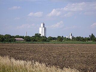
Elmdale is a city in Chase County, Kansas, United States. As of the 2020 census, the population of the city was 40. It is located along U.S. Route 50 highway.

<span class="mw-page-title-main">Matfield Green, Kansas</span> City in Chase County, Kansas

Matfield Green is a city in Chase County, Kansas, United States. As of the 2020 census, the population of the city was 49. It is located along K-177 highway.

<span class="mw-page-title-main">Coldwater, Kansas</span> City in Comanche County, Kansas

Coldwater is a city and county seat of Comanche County, Kansas, United States. As of the 2020 census, the population of the city was 687.

<span class="mw-page-title-main">Elk Falls, Kansas</span> City in Elk County, Kansas

Elk Falls is a city in Elk County, Kansas, United States, along the Elk River. As of the 2020 census, the population of the city was 113.

<span class="mw-page-title-main">Cimarron, Kansas</span> City in Gray County, Kansas

Cimarron is a city in and the county seat of Gray County, Kansas, United States. As of the 2020 census, the population of the city was 1,981. It is located along Highway 50.

<span class="mw-page-title-main">Holton, Kansas</span> City in Jackson County, Kansas

Holton is a city in and the county seat of Jackson County, Kansas, United States. As of the 2020 census, the population of the city was 3,401.

<span class="mw-page-title-main">Oskaloosa, Kansas</span> City and County seat in Kansas, United States

Oskaloosa is a city in and the county seat of Jefferson County, Kansas, United States. As of the 2020 census, the population of the city was 1,110.

<span class="mw-page-title-main">Lakin, Kansas</span> City in Kearny County, Kansas

Lakin is a city in and the county seat of Kearny County, Kansas, United States. As of the 2020 census, the population of the city was 2,205. It is located along Highway 50.

<span class="mw-page-title-main">Kingman, Kansas</span> City in Kingman County, Kansas

Kingman is a city in and the county seat of Kingman County, Kansas, United States. As of the 2020 census, the population of the city was 3,105.

<span class="mw-page-title-main">Durham, Kansas</span> City in Marion County, Kansas

Durham is a city in Marion County, Kansas, United States. As of the 2020 census, the population of the city was 89. The city took its name from Durham cattle. It is located about 8.5 miles (14 km) north of Hillsboro on the west side of K-15 highway next to a railroad.

<span class="mw-page-title-main">Lehigh, Kansas</span> City in Marion County, Kansas

Lehigh is a city in Marion County, Kansas, United States. As of the 2020 census, the population of the city was 161. It is located between Hillsboro and Canton on the north side of U.S. Route 56.

<span class="mw-page-title-main">Marion, Kansas</span> City in Marion County, Kansas

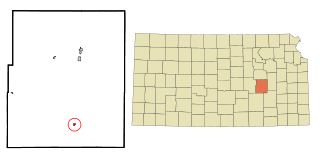
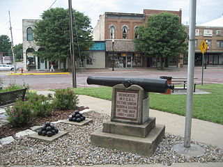
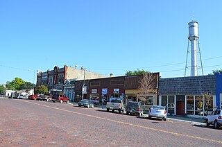
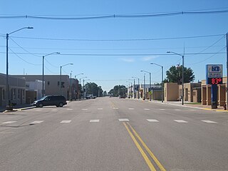
Marion is a city in, and the county seat of, Marion County, Kansas, United States. As of the 2020 census, the population of the city was 1,922. The city was named in honor of Francis Marion, a brigadier general of the American Revolutionary War, known as the "Swamp Fox".

<span class="mw-page-title-main">Paola, Kansas</span> City and County seat in Kansas, United States

Paola is a city in and the county seat of Miami County, Kansas, United States. As of the 2020 census, the population of the city was 5,768.

<span class="mw-page-title-main">Lyndon, Kansas</span> City in Osage County, Kansas

Lyndon is a city in, and the county seat of Osage County, Kansas, United States. As of the 2020 census, the population of the city was 1,037.

<span class="mw-page-title-main">Chase, Kansas</span> City in Rice County, Kansas

Chase is a city in Rice County, Kansas, United States. As of the 2020 census, the population of the city was 396.

<span class="mw-page-title-main">Neosho Falls, Kansas</span> City in Woodson County, Kansas, United States

Neosho Falls is a city in Woodson County, Kansas, United States. As of the 2020 census, the population of the city was 134.

<span class="mw-page-title-main">Cottonwood Shores, Texas</span> City in Texas, United States

Cottonwood Shores is a city in Burnet County, Texas, United States. The population was 1,123 at the 2010 census.

References

  1. 1 2 3 4 5 "Cottonwood Falls, Kansas", Geographic Names Information System , United States Geological Survey, United States Department of the Interior
  2. 1 2 3 "City of Cottonwood Falls". The League of Kansas Municipalities. May 26, 2019.
  3. "2019 U.S. Gazetteer Files". United States Census Bureau. Retrieved July 24, 2020.
  4. 1 2 "Profile of Cottonwood Falls, Kansas in 2020". United States Census Bureau. Archived from the original on November 11, 2021. Retrieved November 11, 2021.
  5. Blackmar, Frank Wilson (1912). Kansas: A Cyclopedia of State History, Embracing Events, Institutions, Industries, Counties, Cities, Towns, Prominent Persons, Etc. Standard Publishing Company. pp.  459.
  6. William G. Cutler's History of the State of Kansas http://www.kancoll.org/books/cutler/chase/chase-co-p1.html
  7. "Kansas Post Offices, 1828-1961 (archived)". Kansas Historical Society. Archived from the original on October 9, 2013. Retrieved June 5, 2014.
  8. "US Gazetteer files: 2010, 2000, and 1990". United States Census Bureau. February 12, 2011. Retrieved April 23, 2011.
  9. "US Gazetteer files 2010". United States Census Bureau. Archived from the original on July 2, 2012. Retrieved July 6, 2012.
  10. 1 2 "NOAA Online Weather Data – NWS Wichita". National Weather Service. Retrieved November 21, 2023.
  11. "U.S. Climate Normals Quick Access – Station: Cottonwood Falls, KS". National Oceanic and Atmospheric Administration. Retrieved November 21, 2023.
  12. Prairie Fire Festival - Kansas Travel
  13. National Register of Historic Places - Cartter Building
  14. National Register of Historic Places - Chase County Courthouse
  15. National Register of Historic Places - Chase County National Bank
  16. National Register of Historic Places - Cottonwood River Bridge
  17. Cottonwood Falls Dam & Bridge - Kansas Travel
  18. National Register of Historic Places - Samuel N Wood House
  19. Kansas Historical Marker - A Landmark Of Distinction
  20. Chase Lake Falls - Kansas Travel
  21. "US Census Bureau, Table P16: HOUSEHOLD TYPE". data.census.gov. Retrieved January 2, 2024.
  22. 1 2 3 4 5 "US Census Bureau, Table DP1: PROFILE OF GENERAL POPULATION AND HOUSING CHARACTERISTICS". data.census.gov. Retrieved January 2, 2024.
  23. Bureau, US Census. "Gazetteer Files". Census.gov. Retrieved December 30, 2023.
  24. "US Census Bureau, Table P1: RACE". data.census.gov. Retrieved January 2, 2024.
  25. "US Census Bureau, Table P2: HISPANIC OR LATINO, AND NOT HISPANIC OR LATINO BY RACE". data.census.gov. Retrieved January 2, 2024.
  26. "US Census Bureau, Table S1101: HOUSEHOLDS AND FAMILIES". data.census.gov. Retrieved January 2, 2024.
  27. "US Census Bureau, Table S1501: EDUCATIONAL ATTAINMENT". data.census.gov. Retrieved January 2, 2024.
  28. "US Census Bureau, Table S1903: MEDIAN INCOME IN THE PAST 12 MONTHS (IN 2020 INFLATION-ADJUSTED DOLLARS)". data.census.gov. Retrieved January 2, 2024.
  29. "US Census Bureau, Table S2001: EARNINGS IN THE PAST 12 MONTHS (IN 2020 INFLATION-ADJUSTED DOLLARS)". data.census.gov. Retrieved January 2, 2024.
  30. "US Census Bureau, Table S1701: POVERTY STATUS IN THE PAST 12 MONTHS". data.census.gov. Retrieved January 2, 2024.
  31. "US Census Bureau, Table S1702: POVERTY STATUS IN THE PAST 12 MONTHS OF FAMILIES". data.census.gov. Retrieved January 2, 2024.
  32. "U.S. Census website". United States Census Bureau . Retrieved July 6, 2012.
  33. "U.S. Census website". United States Census Bureau . Retrieved January 31, 2008.
  34. Cottonwood Falls - Government Archived 2010-04-10 at the Wayback Machine
  35. "Chase County USD 284". USD 284. Retrieved January 1, 2017.
  36. "Cottonwood Falls Wins District at Florence", The Emporia Gazette, 3 March 1958, p.5.
  37. Chase County Airport map
  38. Chase County Airport information Archived 2010-03-28 at the Wayback Machine
  39. "Not connected and no Netflix: It's frankly embarrassing' in these Kansas towns". The Wichita Eagle. February 9, 2020. Archived from the original on February 9, 2020.
  40. 'Wisconsin Blue Book 1933,' Biographical Sketch of Harley A. Martin, pg. 253

Further reading