

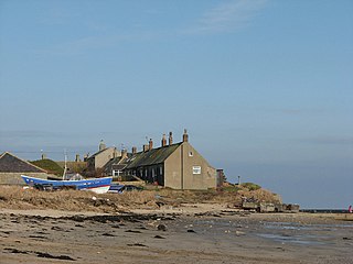
Collieston is a small former fishing village on the North Sea coast in Aberdeenshire, Scotland. The village lies just north of the Sands of Forvie Special Protection Area, between Cruden Bay and Newburgh.
Collieston is a small former fishing village on the North Sea coast in Aberdeenshire, Scotland. The village lies just north of the Sands of Forvie Special Protection Area, between Cruden Bay and Newburgh.
The earliest recorded history of Collieston is of the arrival of St Ternan, a Columban monk on a mission to convert the local picts to Christianity. There is, however, evidence that people lived here during much earlier times.
Collieston was established as a fishing village by the 16th century, and it provides the first safe harbour in over fifteen miles of beaches and dunes stretching north from Aberdeen. Fishing for herring, haddock, whiting and cod flourished in the 17th century and 18th century and was the foundation of Collieston's economy. The village became known for 'Collieston Speldings', salted and sun-dried haddock and whiting, a popular delicacy throughout Britain. As drift netting developed during the mid 19th century, the fishing began to decline and the focus of the industry shifted to places like Peterhead because the harbour at Collieston was too small to safely accommodate the larger boats needed.
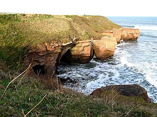
The numerous sea caves in the nearby cliffs, and small coves with shingle beaches provided ideal terrain for smugglers. In the late 18th century it was estimated by the Excise that up to 8000 gallons of foreign spirits were being illegally landed in the area every month. In 1798, the notorious village smuggler, Phillip Kennedy, was killed by a blow from an exciseman's cutlass. His grave and tombstone still stands in the village graveyard.
A ship from the Spanish Armada, the Santa Caterina, carrying arms for the Earl of Erroll is said to have sunk just off the rocky point of St Catherine's Dub in 1594. In retaliation for the Earl's involvement in the Catholic plot against him, James VI blew up the Earl's castle which stood on the cliffs, a mile north of Collieston. The Earl went on to rebuild Slains Castle, six miles further up the coast, in 1597.
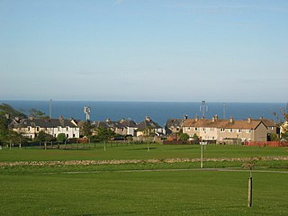
Collieston is now mainly a commuter village serving Aberdeen, and is largely given over to tourists during the summer months.
In September 1930, T. E. Lawrence, better known as Lawrence of Arabia, rented a cottage in the village while on leave from the RAF. He referred to the cottage in his writings as "the nearest hovel to the high-tide mark". This cottage still exists, although it has since been modernised and extensively rebuilt.

Stonehaven is a town in Scotland. It lies on Scotland's northeast coast and had a population of 11,602 at the 2011 Census. After the demise of the town of Kincardine, which was gradually abandoned after the destruction of its royal castle in the Wars of Independence, the Scottish Parliament made Stonehaven the successor county town of Kincardineshire. It is currently administered as part of the unitary authority of Aberdeenshire. Stonehaven had grown around an Iron Age fishing village, now the "Auld Toon", and expanded inland from the seaside. As late as the 16th century, old maps indicate the town was called Stonehyve,Stonehive, Timothy Pont also adding the alternative Duniness. It is known informally to locals as Stoney.

Findochty is a village in Moray, Scotland, on the shores of the Moray Firth; historically it was part of Banffshire. The Gaelic name of the village was recorded by Diack using his own transcription method as fanna-guchti, which is of unclear meaning. One of the earliest references to Findochty is in 1440, when the king granted Findachtifeild to John Dufe, son of John Dufe. The lands passed from the Duffs to the Ogilvies of Findlater, and subsequently, in 1568, the Ord family acquired the manor, port, custom, and fishers' lands of Findochty, and later built the House of Findochty, known as Findochty Castle, now a ruin, which stands to the west of the village. In 1716 the Ords brought 13 men and 4 boys from Fraserburgh under contract to fish from Findochty, and for a time the harbour was busy with landings of herring and white fish. Findochty expanded as a fishing port through the 1700s and 1800s, and by 1850 was home to 140 fishing boats. But the expansion in the late 1800s of nearby Buckie provided a better harbour, and some of the fishing fleet had left Findochty by 1890. Findochty harbour is now used mostly by pleasure craft and is a good sun spot when the tide is out. A local artist, Correna Cowie, created a statue in 1959 of a seated fisherman, known as The Mannie, who watches over the harbour.

Liscannor is a coastal village in County Clare, Ireland.

Cullen is a village and former royal burgh in Moray, Scotland, on the North Sea coast 20 miles east of Elgin. The village had a population of 1,327 in 2001. Cullen is noticeably busier in summer than winter due to the number of holiday homes owned. The organs of the wife of Robert the Bruce are said to have been buried in its old kirk (church) after her death in Cullen Castle. Robert the Bruce made an annual payment to the village in gratitude for the treatment of his wife's body and its return south for burial. In 2000, the recent non-payment of this sum by the government was challenged and settled to the village's favour.

Portpatrick is a village and civil parish in the historical county of Wigtownshire, Dumfries and Galloway, Scotland. It is located on the west coast of the Rhins of Galloway. The parish is about 4+1⁄2 miles (7 km) in length and 4 miles (6 km) in breadth, covering 9,300 acres (3,800 ha).

Cruden Bay is a small village in Scotland, on the north coast of the Bay of Cruden in Aberdeenshire, 26 miles (42 km) north of Aberdeen.
The villages of Inverallochy and Cairnbulg lie some four miles east of Fraserburgh, in North East Scotland.
Boulmer is a village in Northumberland, England, on the North Sea coast east of Alnwick. It is home to RAF Boulmer. Boulmer has an independent volunteer lifeboat station.

Findon or Finnan is a fishing village eight miles south of Aberdeen, famous for originating the smoked haddock known as Finnan haddie. The Findon moor has a number of paths through it, many of which run along the cliffs. Deer can often be seen there. Nearby features include the Portlethen Moss Nature Reserve.
Cove Bay, known locally as Cove, is a suburb on the south-east edge of Aberdeen, Scotland.

Auchmithie is a small fishing village in Angus, Scotland, three miles north east of the town of Arbroath. It sits atop a cliff of red sandstone conglomerate of Devonian date, approximately 120 feet above a shingle beach. Among the pebbles on the beach, derived from those weathered out of the cliffs, a significant percentage are jasper, predominantly dark red, with rarer examples green or yellow.

Whinnyfold or Whinneyfold is a small coastal village at the southern end of the Bay of Cruden in Aberdeenshire, Scotland.

Kildonan is a village on the south coast of the Isle of Arran in the Firth of Clyde, Scotland. The village is within the parish of Kilmory.

Dunure is a small village in the South Ayrshire area of Scotland about 5 miles (8.0 km) from Ayr, Scotland. It is located on the coast of the Firth of Clyde, and is near to Maybole, south of Ayr.

Muchalls is a small coastal ex-fishing village in Kincardineshire, Scotland, south of Newtonhill and north of Stonehaven. Muchalls is situated slightly north of a smaller hamlet known as the Bridge of Muchalls. At the western edge of Muchalls is the historic Saint Ternan's Church. The rugged North Sea coastline near Muchalls features numerous cliffs, sea stacks and headlands, not infrequently in haar. The Grim Brigs headland is situated at Muchalls southern edge and Doonie Point headland is approximately 1.5 kilometres south.

A fishing village is a village, usually located near a fishing ground, with an economy based on catching fish and harvesting seafood. The continents and islands around the world have coastlines totalling around 356,000 kilometres (221,000 mi). From Neolithic times, these coastlines, as well as the shorelines of inland lakes and the banks of rivers, have been punctuated with fishing villages. Most surviving fishing villages are traditional.

The Castle of Rattray was a medieval Scottish castle, with multiple variations on its structure over approximately six centuries. Originally built as a "late 12th- or early 13th century defensive motte" it provided protection for Starny Keppie harbour and Rattray village. Sometime between 1214 and 1233 it was upgraded by William Comyn, jure uxoris Earl of Buchan before being destroyed in the 1308 Harrying of Buchan. After Comyn's timber castle was burned down it was replaced by a stronger stone castle which was engulfed during a 1720 sand storm along with nearby Rattray village. After the storm, the castle was not dug out and remains covered to this day. The castle was described by W. Douglas Simpson as one of the nine castles of the Knuckle, referring to the rocky headland of north-east Aberdeenshire.
Boddam is a coastal village in Aberdeenshire, Scotland. It is 29 miles (47 km) north of Aberdeen and 3 miles (4.8 km) south of Peterhead. The settlement of Stirling Village lies immediately to the west. Sea cliffs rise to 200 feet (61 m), south of the village: a coastal path leads along these to the Bullers of Buchan.

Old Slains Castle is a ruined castle near Collieston in Aberdeenshire, Scotland.
The Berwickshire Coastal Path is a walking route some 48 kilometres (30 mi) long. It follows the eastern coastline of Scotland from Cockburnspath in the Scottish Borders to Berwick upon Tweed, just over the border in England. At Cockburnspath the path links with the Southern Upland Way and the John Muir Way.
| Wikimedia Commons has media related to Collieston . |
Settlements and places of interest in Formartine, Aberdeenshire | ||
|---|---|---|
| Primary settlements |  | |
| Other settlements | ||
| Places of interest | ||
Areas and primary settlements in Aberdeenshire (see also: Aberdeen City) | ||
|---|---|---|
| in Banff and Buchan |  | |
| in Buchan | ||
| in Formartine | ||
| in Garioch | ||
| in Kincardine and Mearns | ||
| in Marr | ||