
Greenbrier County is a county in the U.S. state of West Virginia. As of the 2020 census, the population was 32,977. Its county seat is Lewisburg. The county was formed in 1778 from Botetourt and Montgomery counties in Virginia.

The Greenbrier River is a tributary of the New River, 162 miles (261 km) long, in southeastern West Virginia, in the United States. Via the New, Kanawha and Ohio rivers, it is part of the watershed of the Mississippi River, draining an area of 1,656 square miles (4,290 km2). It is one of the longest rivers in West Virginia.

Droop Mountain Battlefield State Park is a state park located on Droop Mountain in Pocahontas County, West Virginia. The park was the site of the Battle of Droop Mountain, the last major battle of the American Civil War in the state taking place on November 6, 1863. John D. Sutton, a West Virginia private in the Union Army at the battle, became the leader in the movement to create the park when he served in the West Virginia House of Delegates. Dedicated on July 4, 1928, Droop Mountain Battlefield became the first state park in West Virginia.

Winchester National Cemetery is a United States National Cemetery located in the city of Winchester in Frederick County, Virginia. Administered by the United States Department of Veterans Affairs, it encompasses 4.9 acres (2.0 ha), and as of the end of 2005, it had 5,561 interments. It is closed to new interments.

The Battle of Droop Mountain occurred in Pocahontas County, West Virginia, on November 6, 1863, during the American Civil War. A Union brigade commanded by Brigadier General William W. Averell defeated a smaller Confederate force commanded by Brigadier General John Echols and Colonel William L. "Mudwall" Jackson. Confederate forces were driven from their breastworks on Droop Mountain, losing weapons and equipment. They escaped southward through Lewisburg, West Virginia; hours before a second Union force commanded by Brigadier General Alfred N. Duffié occupied the town.
Droop Mountain is a small mountain in the Allegheny Mountains on the border of Greenbrier and Pocahontas counties in southeastern West Virginia. It was the scene of one of West Virginia's most important battles during the American Civil War—the Battle of Droop Mountain.

White Top is a knob and spur of Cheat Mountain in southeastern Randolph County, West Virginia, USA. Sitting at an elevation of 4,085 feet (1,245 m), it is located just west of the Shavers Fork of Cheat River and Cheat Bridge. While White Top was originally crossed by the Staunton–Parkersburg Turnpike, modern-day U.S. Route 250 skirts the base of the knob beside Shavers Fork to the north and east.

The Confederate Monument in Cynthiana is located on the outer edge of Cynthiana, Kentucky in Battle Grove Cemetery. It was the first monument to the Confederate States of America dedicated in the State of Kentucky, and long believed to be the first Confederate memorial anywhere. Due to the 32nd Indiana Monument having been moved from its original location, the Cynthiana monument is the oldest Civil War monument still standing at its original location, where the second Battle of Cynthiana started, in the then-new town cemetery.

The Fort Early and Jubal Early Monument was started in the early 1900s, and consists of the remains of an American Civil War fort and monument located on a 1.29-acre (5,200 m2) site at Lynchburg, Virginia. Confederate forces under the command of Lt. Gen. Jubal Early constructed the roughly square earthen fort in June 1864 as part of the outer defenses of Lynchburg as the Union Army of West Virginia, under Maj. Gen. David Hunter, advanced from the north and west in an attempt to capture the city during the Battle of Lynchburg. It is the only section of the Lynchburg defenses still in existence.

The Confederate Monument in Bracken County, Kentucky, in Augusta, Kentucky, honors eight unknown Confederate soldiers who were killed attacking Augusta in September 1862. Confederate Colonel Basil W. Duke led a force of Confederate soldiers to raid the town, on September 27, 1862, only to be driven back by a home guard force numbering 100 and backed up by gunboats. Eight Confederate soldiers of the 21 who died were buried in Payne Cemetery. In 1903 the present monument was placed at their burial spot.
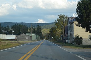
Bartow is a census-designated place (CDP) in Pocahontas County, West Virginia, United States. The population was 111 at the 2010 census.

John Wesley Methodist Church, also known as First Methodist Church, is a historic Methodist church on E. Foster Street in Lewisburg, Greenbrier County, West Virginia. It was built in 1820, and is a two-story, brick meeting house building with Greek Revival style design elements. It originally measures 58 feet long by 47 feet wide. In 1835, a vestibule addition added 10 feet to the length. The interior features a "slave gallery." During the Battle of Lewisburg, a cannonball struck the southwest corner and the repairs remain visible.
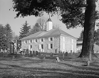
Old Stone Church is a historic Presbyterian church located at Lewisburg, Greenbrier County, West Virginia.

The Virginia Monument, also commonly referred to as "The State of Virginia Monument", is a Battle of Gettysburg memorial to the commonwealth's "Sons at Gettysburg" with a bronze statue of Robert E. Lee on his horse Traveller and a "bronze group of figures representing the Artillery, Infantry, and Cavalry of the Confederate Army". The equestrian statue is atop a granite pedestal and the group of six standing figures is on a sculpted bronze base with the figures facing the Field of Pickett's Charge and the equestrian statue of Union General George G. Meade on Cemetery Ridge. The granite pedestal without either sculpture was dedicated on June 30, 1913 for the 1913 Gettysburg reunion. On June 8, 1917, Virginia governor Henry C. Stuart presented the completed memorial to the public.
Morlunda, also known as the Col. Samuel McClung Place and Oscar Nelson Farm, is a historic home located near Lewisburg, Greenbrier County, West Virginia. It was built in 1827–1828, and consists of a main house with ell. The main house is a two-story brick building measuring 56 feet long and 21 feet deep. The ell measures 48 feet and it connects to a 1+1⁄2-story formerly detached kitchen.

Greenbrier County Courthouse is a historic courthouse building located at Lewisburg, Greenbrier County, West Virginia. In 1973 the courthouse and the adjacent spring house, the Lewis Spring, were listed on the National Register of Historic Places. and are a historic and
Hopkins Mountain Historic District is a national historic district located in the Monongahela National Forest near Alvon, Greenbrier County, West Virginia. The district encompasses two contributing buildings, one contributing site, and two contributing structures. It includes the Mountain Tower Road, fire tower and the fireman'sresidence. They were all constructed by the members of Camp Alvon of the Civilian Conservation Corps (CCC) in 1935. The house is a Bungalow style, gable roofed dwelling measuring 14 by 20 feet. Located nearby is a contemporary privy with board-and-batten siding and a gable roof, also built by the CCC. The property also includes the Civil War Trail. It was used by the Virginia 26th Battalion under the command of Lt. Colonel George M. Edgar for its retreat from the Battle of Droop Mountain on November 6 and 7, 1863. Also on the property is a logging tramway in use from about 1908 to the 1920s.
The Camp Bartow Historic District — centered on the historic inn called "Traveller's Repose" and the site of the Battle of Greenbrier River (1861) — is a national historic district located at Bartow, Pocahontas County, West Virginia, United States. It is situated at the foot of Burner Mountain, at a bend in the East Fork Greenbrier River, where U.S. Route 28 intersects U.S. Route 250.
The Civil War Trust's Civil War Discovery Trail is a heritage tourism program that links more than 600 U.S. Civil War sites in more than 30 states. The program is one of the White House Millennium Council's sixteen flagship National Millennium Trails. Sites on the trail include battlefields, museums, historic sites, forts and cemeteries.

The Battle of Lewisburg occurred in Greenbrier County, Virginia, on May 23, 1862, during the American Civil War. A Union brigade commanded by Colonel George Crook soundly defeated a larger Confederate force commanded by Brigadier General Henry Heth. Panicked Confederate forces escaped by crossing and burning a bridge across the Greenbrier River.


