National Register of Historic Places listings in Randolph County, West Virginia

Last updated

Location of Randolph County in West Virginia Map of West Virginia highlighting Randolph County.svg
Location of Randolph County in West Virginia

This is a list of the National Register of Historic Places listings in Randolph County, West Virginia.

Contents

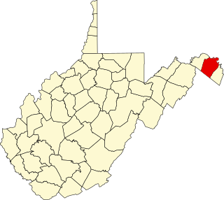
This is intended to be a complete list of the properties and districts on the National Register of Historic Places in Randolph County, West Virginia, United States. The locations of National Register properties and districts for which the latitude and longitude coordinates are included below, may be seen in an online map. [1]

There are 37 properties and districts listed on the National Register in the county, 1 of which is a National Historic Landmark.


    This National Park Service list is complete through NPS recent listings posted November 3, 2023. [2]

Map all coordinates using: OpenStreetMap
Contents: Counties in West Virginia

Current listings

[3] Name on the Register [4] ImageDate listed [5] Location City or townDescription
1 Albert and Liberal Arts Halls
Albert and Liberal Arts Halls Albert and Liberal Arts Halls.jpg
Albert and Liberal Arts Halls
August 29, 1979
(#79002599)
Davis and Elkins College campus
38°55′49″N79°50′46″W / 38.9303°N 79.8461°W / 38.9303; -79.8461 (Albert and Liberal Arts Halls)
Elkins
2 Baldwin-Chandlee Supply Company-Valley Supply Company
Baldwin-Chandlee Supply Company-Valley Supply Company Baldwin-Chandlee Supply Company-Valley Supply Company (east).jpg
Baldwin-Chandlee Supply Company-Valley Supply Company
December 4, 1998
(#98001478)
Junction of 10th and Railroad Sts.
38°55′18″N79°51′14″W / 38.9217°N 79.8539°W / 38.9217; -79.8539 (Baldwin-Chandlee Supply Company-Valley Supply Company)
Elkins
3 Beverly Historic District
Beverly Historic District The Beverly Heritage Center -- the center of the Beverly Historic District.jpg
Beverly Historic District
January 11, 1980
(#80004040)
US 219/US 250/WV 55/WV 92; Roughly bounded by Dodson Run, Files Cr., Tygart Valley R. & Lewis St.
38°50′29″N79°52′30″W / 38.8414°N 79.875°W / 38.8414; -79.875 (Beverly Historic District)
Beverly Second set of addresses represents a boundary increase 2014-12-16
4 Blackman-Bosworth Store
Blackman-Bosworth Store Blackman-Bosworth Store.jpg
Blackman-Bosworth Store
April 14, 1975
(#75001897)
Main and Court Sts.
38°50′27″N79°52′32″W / 38.8408°N 79.8756°W / 38.8408; -79.8756 (Blackman-Bosworth Store)
Beverly
5 Butcher Hill Historic District
Butcher Hill Historic District Butcher Hill Historic District 2021c.jpg
Butcher Hill Historic District
November 9, 1989
(#89001784)
East of Beverly
38°50′33″N79°51′02″W / 38.8425°N 79.8506°W / 38.8425; -79.8506 (Butcher Hill Historic District)
Beverly
6 Cheat Summit Fort
Cheat Summit Fort Cheat Summit Fort - Earthworks.jpg
Cheat Summit Fort
September 28, 1990
(#90001445)
County Route 250/4, west of FR 233 at White Top [6] [7]
38°37′28″N79°52′36″W / 38.6244°N 79.8767°W / 38.6244; -79.8767 (Cheat Summit Fort)
Huttonsville
7 Davis and Elkins Historic District
Davis and Elkins Historic District Davis and Elkins Gate House.jpg
Davis and Elkins Historic District
June 19, 1996
(#96001129)
Davis and Elkins College campus
38°55′48″N79°50′50″W / 38.93°N 79.8472°W / 38.93; -79.8472 (Davis and Elkins Historic District)
Elkins
8 Davis & Elkins College Historic District
Davis & Elkins College Historic District Davis and Elkins Gate House.jpg
Davis & Elkins College Historic District
November 2, 2023
(#100009540)
Portions of Campus Drive, Harpertown Road, Graceland Drive, Allen Street & Residential Drive, and College Drive (Davis and Elkins College campus)
38°55′48″N79°50′50″W / 38.93°N 79.8473°W / 38.93; -79.8473 (Davis & Elkins College Historic District)
Elkins
9 Davis Memorial Presbyterian Church
Davis Memorial Presbyterian Church Davis Memorial Presbyterian Church.jpg
Davis Memorial Presbyterian Church
April 20, 1984
(#84003664)
450 Randolph Ave.
38°55′39″N79°50′53″W / 38.9274°N 79.8480°W / 38.9274; -79.8480 (Davis Memorial Presbyterian Church)
Elkins
10 Day-Vandevander Mill
Day-Vandevander Mill Day-Vandevander Mill.jpg
Day-Vandevander Mill
July 21, 1987
(#87001173)
WV 32
38°55′57″N79°31′16″W / 38.9325°N 79.5211°W / 38.9325; -79.5211 (Day-Vandevander Mill)
Harman
11 Downtown Elkins Historic District
Downtown Elkins Historic District Elkins West Virginia Davis Avenue.jpg
Downtown Elkins Historic District
November 22, 1995
(#95001324)
Roughly bounded by Railroad Ave., 5th St., Randolph Ave., Henry Ave. and 1st St.
38°55′28″N79°50′57″W / 38.9244°N 79.8492°W / 38.9244; -79.8492 (Downtown Elkins Historic District)
Elkins
12 Elkins Milling Company
Elkins Milling Company Elkins Milling Company.jpg
Elkins Milling Company
February 2, 2005
(#04001595)
2½ Railroad Ave.
38°55′23″N79°51′05″W / 38.9231°N 79.8514°W / 38.9231; -79.8514 (Elkins Milling Company)
Elkins
13 Senator Stephen Benton Elkins House
Senator Stephen Benton Elkins House Senator Stephen Benton Elkins House.jpg
Senator Stephen Benton Elkins House
September 2, 1982
(#82004329)
Davis and Elkins College campus
38°55′51″N79°50′50″W / 38.9308°N 79.8472°W / 38.9308; -79.8472 (Senator Stephen Benton Elkins House)
Elkins
14 First Ward School
First Ward School First Ward School.jpg
First Ward School
December 30, 2009
(#09001193)
S. Davis Ave. and 13th St.
38°55′03″N79°51′06″W / 38.9175°N 79.8516°W / 38.9175; -79.8516 (First Ward School)
Elkins
15 Fort Marrow July 30, 2010
(#10000511)
North corner U.S. Route 219 and County Route 219/16
38°38′00″N80°01′21″W / 38.6333°N 80.0225°W / 38.6333; -80.0225 (Fort Marrow)
Huttonsville Also known as Camp Elkwater [8]
16 Glady Presbyterian Church and Manse
Glady Presbyterian Church and Manse Glady Presbyterian Church.jpg
Glady Presbyterian Church and Manse
November 30, 2005
(#05001347)
Junction of Randolph Ave. and 1st St.
38°47′52″N79°43′10″W / 38.7978°N 79.7194°W / 38.7978; -79.7194 (Glady Presbyterian Church and Manse)
Glady
17 Graceland
Graceland Graceland (Elkins, West Virginia).jpg
Graceland
September 17, 1970
(#70000666)
Davis and Elkins College campus
38°55′51″N79°50′57″W / 38.9308°N 79.8492°W / 38.9308; -79.8492 (Graceland)
Elkins
18 Graham-Davis Historic District April 19, 2021
(#100006396)
Generally bounded by Randolph and South Randolph Aves., 11th St., Granny's Ln., and the Tygart Valley R.
38°55′21″N79°50′42″W / 38.9226°N 79.8450°W / 38.9226; -79.8450 (Graham-Davis Historic District)
Elkins
19 Helvetia
Helvetia Helvetia WV-Shield Sign.jpg
Helvetia
November 29, 1978
(#78002810)
Junction of County Route 45 and County Route 46
38°42′19″N80°12′14″W / 38.7053°N 80.2039°W / 38.7053; -80.2039 (Helvetia)
Helvetia
20 E. E. Hutton House June 11, 1975
(#75001898)
Junction of U.S. Routes 219 and 250 and Union St.
38°42′56″N79°58′45″W / 38.7156°N 79.9792°W / 38.7156; -79.9792 (E. E. Hutton House)
Huttonsville
21 Dr. John C. Irons House
Dr. John C. Irons House Dr. John C. Irons House.jpg
Dr. John C. Irons House
December 15, 1998
(#98001479)
116 2nd St.
38°55′25″N79°50′58″W / 38.9236°N 79.8494°W / 38.9236; -79.8494 (Dr. John C. Irons House)
Elkins
22 Gov. H. Guy Kump House
Gov. H. Guy Kump House Gov. H. Guy Kump House.jpg
Gov. H. Guy Kump House
August 18, 1983
(#04000319)
Randolph Ave. and 11th St. [9] [10] [11]
38°55′04″N79°50′33″W / 38.9178°N 79.8425°W / 38.9178; -79.8425 (Gov. H. Guy Kump House)
Elkins
23 Middle Mountain Cabins
Middle Mountain Cabins Monongahela National Forest - Middle Mountain Cabins.jpg
Middle Mountain Cabins
September 27, 1990
(#90001447)
Eastern side of Middle Mountain Rd. at Camp Five Run, Monongahela National Forest
38°41′18″N79°44′03″W / 38.6883°N 79.7342°W / 38.6883; -79.7342 (Middle Mountain Cabins)
Wymer
24 New Deal Resources in Kumbrabow State Forest Historic District August 7, 2019
(#100002855)
219/16, Kumbrabow Rd.
38°37′52″N80°05′04″W / 38.6312°N 80.0844°W / 38.6312; -80.0844 (New Deal Resources in Kumbrabow State Forest Historic District)
Huttonsville
25 Fred A. Perley House September 14, 1988
(#88001453)
Address Restricted
Jenningston
26 Pinecrest
Pinecrest Pinecrest at Elkins, entrance.jpg
Pinecrest
December 11, 1979
(#79002600)
Kerens Hill
38°55′53″N79°51′11″W / 38.9314°N 79.8531°W / 38.9314; -79.8531 (Pinecrest)
Elkins
27 Randolph County Courthouse and Jail
Randolph County Courthouse and Jail Randolph County Courthouse and Jail.jpg
Randolph County Courthouse and Jail
November 28, 1980
(#80004041)
Randolph Ave. and High St.
38°55′22″N79°50′35″W / 38.9228°N 79.8431°W / 38.9228; -79.8431 (Randolph County Courthouse and Jail)
Elkins
28 Rich Mountain Battlefield
Rich Mountain Battlefield Battle of Rich Mountain-Hart House.jpg
Rich Mountain Battlefield
July 17, 1992
(#92000899)
6 miles west of Beverly on Rich Mountain Rd. (County Route 37/8)
38°52′01″N79°56′41″W / 38.8669°N 79.9447°W / 38.8669; -79.9447 (Rich Mountain Battlefield)
Beverly
29 Riverside School
Riverside School Riverside School.jpg
Riverside School
December 30, 2009
(#09001194)
Block No. 1, River St.
38°55′20″N79°50′52″W / 38.9223°N 79.8479°W / 38.9223; -79.8479 (Riverside School)
Elkins
30 Scott Hill
Scott Hill Scott Hill (rear).jpg
Scott Hill
December 22, 2008
(#08001240)
2000 Livingston Ave.
38°54′48″N79°51′40″W / 38.91325°N 79.8610°W / 38.91325; -79.8610 (Scott Hill)
Elkins
31 See-Ward House August 25, 1988
(#88000671)
U.S. Routes 219/250
38°43′31″N79°58′22″W / 38.7253°N 79.9728°W / 38.7253; -79.9728 (See-Ward House)
Mill Creek
32 Taylor-Condry House
Taylor-Condry House TAYLOR-CONDRY HOUSE, ELKINS, RANDOLPH COUNTY, WV.jpg
Taylor-Condry House
August 18, 1983
(#83003252)
1700 Taylor Ave.
38°54′48″N79°51′28″W / 38.9133°N 79.8578°W / 38.9133; -79.8578 (Taylor-Condry House)
Elkins
33 Tygart Valley Homesteads Historic District
Tygart Valley Homesteads Historic District Tygart Valley Homesteads, West Virginia.jpg
Tygart Valley Homesteads Historic District
July 22, 2004
(#04000304)
Roughly bounded by U.S. Routes 219/250 and County Roads 21 and 38
38°46′37″N79°54′25″W / 38.7769°N 79.9069°W / 38.7769; -79.9069 (Tygart Valley Homesteads Historic District)
Dailey
34 Tygarts Valley Church
Tygarts Valley Church West Virginia - Tygarts Valley Church - .jpg
Tygarts Valley Church
April 15, 1986
(#86000797)
U.S. Route 219
38°43′02″N79°58′41″W / 38.7172°N 79.9781°W / 38.7172; -79.9781 (Tygarts Valley Church)
Huttonsville
35 Warfield-Dye Residence
Warfield-Dye Residence Warfield-Dye Residence.jpg
Warfield-Dye Residence
November 13, 1997
(#97001412)
318 Buffalo St.
38°55′42″N79°50′42″W / 38.9283°N 79.845°W / 38.9283; -79.845 (Warfield-Dye Residence)
Elkins
36 Wees Historic District
Wees Historic District Wees Historic District.jpg
Wees Historic District
March 24, 2006
(#06000164)
Generally bounded by Randolph and S. Randolph Aves., Sycamore St., Diamond St. and Boundary and Terrace Aves.
38°55′39″N79°50′33″W / 38.9275°N 79.8425°W / 38.9275; -79.8425 (Wees Historic District)
Elkins
37 West Virginia Children's Home
West Virginia Children's Home West Virginia Children's Home.jpg
West Virginia Children's Home
November 4, 1994
(#94001287)
230 Heavener Ave.
38°55′58″N79°51′29″W / 38.9328°N 79.8581°W / 38.9328; -79.8581 (West Virginia Children's Home)
Elkins

Former listings

[3] Name on the RegisterImageDate listedDate removedLocationCity or townDescription
1 Elkins Round Barn July 9, 1985
(#85001547)
December 17, 1990 US 219
Elkins

See also

Related Research Articles

<span class="mw-page-title-main">National Register of Historic Places listings in Lancaster County, Pennsylvania</span>

This is a list of the National Register of Historic Places listings in Lancaster County, Pennsylvania.

<span class="mw-page-title-main">National Register of Historic Places listings in York County, Pennsylvania</span>

This is a list of the National Register of Historic Places listings in York County, Pennsylvania.

<span class="mw-page-title-main">National Register of Historic Places listings in Cuyahoga County, Ohio</span>

This is a list of the National Register of Historic Places listings in Cuyahoga County, Ohio.

<span class="mw-page-title-main">National Register of Historic Places listings in Charleston County, South Carolina</span>

This is a list of the National Register of Historic Places listings in Charleston County, South Carolina.

<span class="mw-page-title-main">National Register of Historic Places listings in Licking County, Ohio</span>

This is a list of the National Register of Historic Places listings in Licking County, Ohio.

<span class="mw-page-title-main">National Register of Historic Places listings in Ross County, Ohio</span>

This is a list of the National Register of Historic Places listings in Ross County, Ohio.

<span class="mw-page-title-main">National Register of Historic Places listings in Belmont County, Ohio</span>

This is a list of the National Register of Historic Places listings in Belmont County, Ohio.

<span class="mw-page-title-main">National Register of Historic Places listings in Beaver County, Pennsylvania</span>

This is a list of the National Register of Historic Places listings in Beaver County, Pennsylvania.

<span class="mw-page-title-main">National Register of Historic Places listings in Berkeley County, West Virginia</span>

This is a list of the National Register of Historic Places listings in Berkeley County, West Virginia.

<span class="mw-page-title-main">National Register of Historic Places listings in Monongalia County, West Virginia</span>

This is a list of the National Register of Historic Places listings in Monongalia County, West Virginia.

<span class="mw-page-title-main">National Register of Historic Places listings in Pocahontas County, West Virginia</span>

This is a list of the National Register of Historic Places listings in Pocahontas County, West Virginia.

<span class="mw-page-title-main">National Register of Historic Places listings in Hocking County, Ohio</span>

This is a list of the National Register of Historic Places listings in Hocking County, Ohio.

<span class="mw-page-title-main">National Register of Historic Places listings in Henry County, Indiana</span>

This is a list of the National Register of Historic Places listings in Henry County, Indiana.

<span class="mw-page-title-main">National Register of Historic Places listings in Randolph County, Indiana</span>

This is a list of the National Register of Historic Places listings in Randolph County, Indiana.

<span class="mw-page-title-main">National Register of Historic Places listings in Hampshire County, West Virginia</span>

This is a list of the National Register of Historic Places listings in Hampshire County, West Virginia.

<span class="mw-page-title-main">National Register of Historic Places listings in southern Chester County, Pennsylvania</span>

This is a list of the National Register of Historic Places listings in southern Chester County, Pennsylvania.

<span class="mw-page-title-main">National Register of Historic Places listings in Randolph County, Arkansas</span>

This is a list of the National Register of Historic Places listings in Randolph County, Arkansas.

<span class="mw-page-title-main">National Register of Historic Places listings in Hancock County, West Virginia</span>

This is a list of the National Register of Historic Places listings in Hancock County, West Virginia.

<span class="mw-page-title-main">National Register of Historic Places listings in Braxton County, West Virginia</span>

This is a list of the National Register of Historic Places listings in Braxton County, West Virginia.

<span class="mw-page-title-main">Gov. H. Guy Kump House</span> Historic house in West Virginia, United States

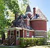
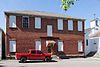
Gov. H. Guy Kump House is a historic home located at Elkins, Randolph County, West Virginia. It was designed by noted Washington, D.C.-architect Clarence L. Harding and built in 1924–1925, as a home for West Virginia Governor Herman G. Kump (1877–1962) and his wife Edna Hall Scott Kump (1887–1957). It is a 2+12-story, 42 foot square, red brick dwelling with a steeply pitched, slate covered gable roof. The front facade features a shallow Doric order entrance portico and it has a porte cochere and sun porch. The house is in a Neo-Federal Revival style with Neo-Georgian Revival elements. In 2008, the house was willed to the city of Elkins.

References

  1. The latitude and longitude information provided in this table was derived originally from the National Register Information System, which has been found to be fairly accurate for about 99% of listings. Some locations in this table may have been corrected to current GPS standards.
  2. National Park Service, United States Department of the Interior, "National Register of Historic Places: Weekly List Actions", retrieved November 3, 2023.
  3. 1 2 Numbers represent an alphabetical ordering by significant words. Various colorings, defined here, differentiate National Historic Landmarks and historic districts from other NRHP buildings, structures, sites or objects.
  4. "National Register Information System". National Register of Historic Places . National Park Service. April 24, 2008.
  5. The eight-digit number below each date is the number assigned to each location in the National Register Information System database, which can be viewed by clicking the number.
  6. The NRIS lists Cheat Summit Fort as "Address Restricted"; location is derived from Monongahela National Forest (Map). 1:126,720. Monongahela National Forest. 2007. ISBN   978-1-59351-857-8.
  7. "Cheat Summit". Monongahela National Forest. Archived from the original on 2009-07-23. Retrieved 2009-01-18.
  8. "Forgotten Fortification Saved at Elkwater". Elkins, West Virginia: The Inter-Mountain. May 16, 2009. Archived from the original on May 10, 2008. Retrieved August 8, 2010.
  9. The NRIS lists the house as "Address Restricted"; location is derived from Gaynor, Anthony (2008-08-16). "Is Elkins Nearing Plan for Kump House?". The Inter-Mountain. Archived from the original on 2011-07-16. Retrieved 2009-01-18.
  10. Gaynor, Anthony (2008-04-23). "Kump House Willed To the City of Elkins". The Inter-Mountain. Archived from the original on 2011-07-17. Retrieved 2009-01-18.
  11. "Google Map for 38° 55' 4" N, 79° 50' 33" W". Google . Retrieved 2009-01-18.