National Register of Historic Places listings in Harrison County, West Virginia

Last updated
Location of Harrison County in West Virginia Map of West Virginia highlighting Harrison County.svg
Location of Harrison County in West Virginia

This is a list of the National Register of Historic Places listings in Harrison County, West Virginia.

Contents

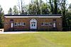
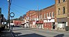
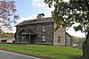
This is intended to be a complete list of the properties and districts on the National Register of Historic Places in Harrison County, West Virginia, United States. The locations of National Register properties and districts for which the latitude and longitude coordinates are included below, may be seen in a Google map. [1]

National Register of Historic Places federal list of historic sites in the United States

The National Register of Historic Places (NRHP) is the United States federal government's official list of districts, sites, buildings, structures, and objects deemed worthy of preservation for their historical significance. A property listed in the National Register, or located within a National Register Historic District, may qualify for tax incentives derived from the total value of expenses incurred preserving the property.

Harrison County, West Virginia County in the United States

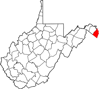
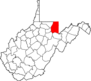
Harrison County is a county in the U.S. state of West Virginia. As of the 2010 United States Census, the population was 69,099. The county seat is Clarksburg.

West Virginia State of the United States of America

West Virginia is a state located in the Appalachian region in the Southern United States that is also considered to be a part of the Middle Atlantic States. It is bordered by Pennsylvania to the north, Maryland to the east and northeast, Virginia to the southeast, Kentucky to the southwest, and Ohio to the northwest. West Virginia is the 41st largest state by area, and is ranked 38th in population. The capital and largest city is Charleston.

There are 21 properties and districts listed on the National Register in the county. Another property was once listed but has been removed.

This National Park Service list is complete through NPS recent listings posted April 12, 2019. [2]
Map all coordinates using: OpenStreetMap  
Download coordinates as: KML  ·  GPX
Contents: Counties in West Virginia

Barbour - Berkeley - Boone - Braxton - Brooke - Cabell - Calhoun - Clay - Doddridge - Fayette - Gilmer - Grant - Greenbrier - Hampshire - Hancock - Hardy - Harrison - Jackson - Jefferson - Kanawha - Lewis - Lincoln - Logan - Marion - Marshall - Mason - McDowell - Mercer - Mineral - Mingo - Monongalia - Monroe - Morgan - Nicholas - Ohio - Pendleton - Pleasants - Pocahontas - Preston - Putnam - Raleigh - Randolph - Ritchie - Roane - Summers - Taylor - Tucker - Tyler - Upshur - Wayne - Webster - Wetzel - Wirt - Wood - Wyoming

National Register of Historic Places listings in Barbour County, West Virginia Wikimedia list article

This is a list of the National Register of Historic Places listings in Barbour County, West Virginia.

National Register of Historic Places listings in Berkeley County, West Virginia Wikimedia list article

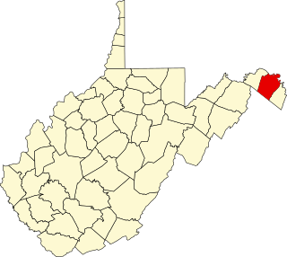
This is a list of the National Register of Historic Places listings in Berkeley County, West Virginia.

National Register of Historic Places listings in Boone County, West Virginia Wikimedia list article

This is a list of the National Register of Historic Places listings in Boone County, West Virginia.

Current listings

[3] Name on the RegisterImageDate listed [4] Location City or townDescription
1 Daniel Bassel House
Daniel Bassel House Daniel Bassel House.jpg
Daniel Bassel House
August 22, 2002
(#02000898)
County Route 25, south of its junction with WV 270
39°09′40″N80°21′11″W / 39.161111°N 80.353056°W / 39.161111; -80.353056 (Daniel Bassel House)
Lost Creek
2 Bridgeport Lamp Chimney Company Bowstring Concrete Arch Bridge January 27, 1997
(#96001571)
Between Mechanic St. and Baltimore & Ohio railroad tracks
39°17′03″N80°15′22″W / 39.284167°N 80.256111°W / 39.284167; -80.256111 (Bridgeport Lamp Chimney Company Bowstring Concrete Arch Bridge)
Bridgeport
3 Clarksburg Downtown Historic District
Clarksburg Downtown Historic District Harrison County Courthouse, Clarksburg, WV.jpg
Clarksburg Downtown Historic District
April 12, 1982
(#82004794)
Roughly bounded by Elk, Creek, 7th, and Main Sts.
39°16′47″N80°20′22″W / 39.279722°N 80.339444°W / 39.279722; -80.339444 (Clarksburg Downtown Historic District)
Clarksburg
4 Edgewood Manor July 6, 2005
(#05000662)
0.25 miles north of U.S. Route 50 interchange on U.S. Route 19
39°18′28″N80°21′05″W / 39.307778°N 80.351389°W / 39.307778; -80.351389 (Edgewood Manor)
Clarksburg
5 Fletcher Covered Bridge June 4, 1981
(#81000601)
County Route 5/29 at junction of County Route 5
39°18′20″N80°28′49″W / 39.305556°N 80.480278°W / 39.305556; -80.480278 (Fletcher Covered Bridge)
Maken
6 Glen Elk Historic District
Glen Elk Historic District Clarksburg Arts Center Warehouse.JPG
Glen Elk Historic District
November 24, 1993
(#93001232)
Roughly bounded by Elk Creek and the Baltimore & Ohio railroad tracks
39°17′03″N80°20′20″W / 39.284167°N 80.338889°W / 39.284167; -80.338889 (Glen Elk Historic District)
Clarksburg
7 Indian Cave Petroglyphs March 16, 1976
(#76001937)
Address Restricted
Good Hope
8 Governor Joseph Johnson House
Governor Joseph Johnson House GOVERNOR JOSEPH JOHNSON HOUSE, BRIDGEPORT, HARRISON COUNTY, WV.jpg
Governor Joseph Johnson House
March 19, 1987
(#87000490)
424 Oakdale Ave.
39°17′07″N80°15′32″W / 39.285278°N 80.258889°W / 39.285278; -80.258889 (Governor Joseph Johnson House)
Bridgeport
9 Lost Creek Baltimore and Ohio Railroad Depot
Lost Creek Baltimore and Ohio Railroad Depot LostCreekWVBnODepot.JPG
Lost Creek Baltimore and Ohio Railroad Depot
July 6, 2005
(#05000660)
Main St., Lost Creek Rd., and County Route 48
39°09′37″N80°21′06″W / 39.160278°N 80.351667°W / 39.160278; -80.351667 (Lost Creek Baltimore and Ohio Railroad Depot)
Lost Creek
10 Quality Hill Historic District
Quality Hill Historic District QUALITY HILL HISTORIC DISTRICT, CLARKSBURG, HARRISON COUNTY, WV.jpg
Quality Hill Historic District
August 22, 1985
(#85001815)
East Main St.
39°16′43″N80°19′55″W / 39.278611°N 80.331944°W / 39.278611; -80.331944 (Quality Hill Historic District)
Clarksburg
11 Quiet Dell School
Quiet Dell School Quiet Dell School.JPG
Quiet Dell School
March 12, 2001
(#01000265)
Off WV 20 on County Route 20/79
39°13′26″N80°18′00″W / 39.223889°N 80.3°W / 39.223889; -80.3 (Quiet Dell School)
Mount Clare
12 Salem College Administration Building
Salem College Administration Building SALEM COLLEGE ADMINISTRATION BUILDING, HARRISON COUNTY, WV;.JPG
Salem College Administration Building
March 30, 1989
(#89000184)
223 W. Main St.
39°17′01″N80°34′02″W / 39.283611°N 80.567222°W / 39.283611; -80.567222 (Salem College Administration Building)
Salem
13 Salem Historic District
Salem Historic District Salem West Virginia.jpg
Salem Historic District
December 2, 1980
(#80004022)
WV 23
39°16′58″N80°33′32″W / 39.282778°N 80.558889°W / 39.282778; -80.558889 (Salem Historic District)
Salem
14 Levi Shinn House
Levi Shinn House LEVI SHINN, SHINNSTON, HARRISON COUNTY WV.jpg
Levi Shinn House
July 16, 1973
(#73001907)
Clarksburg Rd. (U.S. Route 19)
39°23′13″N80°18′40″W / 39.386944°N 80.311111°W / 39.386944; -80.311111 (Levi Shinn House)
Shinnston
15 Shinnston Historic District
Shinnston Historic District SHINNSTON HISTORIC DISTRICT, SHINNSTON, HARRISON COUNTY, WV.jpg
Shinnston Historic District
April 1, 1998
(#98000288)
Roughly bounded by Charles, East, and Clement Sts., and West Fork River
39°23′45″N80°18′03″W / 39.395833°N 80.300833°W / 39.395833; -80.300833 (Shinnston Historic District)
Shinnston
16 Simpson Creek Covered Bridge June 4, 1981
(#81000600)
County Route 24/2 at junction of County Route 24
39°18′31″N80°16′47″W / 39.308611°N 80.279722°W / 39.308611; -80.279722 (Simpson Creek Covered Bridge)
Bridgeport
17 Watters Smith Farm on Duck Creek
Watters Smith Farm on Duck Creek Watters Smith Memorial State Park.jpg
Watters Smith Farm on Duck Creek
May 16, 1974
(#74002003)
County Route 25/6
39°10′12″N80°24′38″W / 39.17°N 80.410556°W / 39.17; -80.410556 (Watters Smith Farm on Duck Creek)
Lost Creek
18 Stealey-Goff-Vance House
Stealey-Goff-Vance House IStealey-Goff-Vance House.jpg
Stealey-Goff-Vance House
September 25, 1979
(#79002580)
123 W. Main St.
39°16′42″N80°20′09″W / 39.278333°N 80.335833°W / 39.278333; -80.335833 (Stealey-Goff-Vance House)
Clarksburg
19 Templemoor
Templemoor TEMPLEMOOR, HARRISON COUNTY, WV.jpg
Templemoor
April 15, 1982
(#82004318)
WV 20
39°08′41″N80°14′27″W / 39.144722°N 80.240833°W / 39.144722; -80.240833 (Templemoor)
Clarksburg
20 Trinity Memorial Methodist Episcopal Church
Trinity Memorial Methodist Episcopal Church Trinity Memorial ME site, Clarksburg.jpg
Trinity Memorial Methodist Episcopal Church
April 26, 1984
(#84003584)
420 Ben St.
39°16′37″N80°20′11″W / 39.276944°N 80.336389°W / 39.276944; -80.336389 (Trinity Memorial Methodist Episcopal Church)
Clarksburg Demolished [5]
21 Waldomore
Waldomore Waldomore Clkb. WV.jpg
Waldomore
October 4, 1978
(#78002797)
W. Pike and N. 4th Sts.
39°16′54″N80°20′25″W / 39.281667°N 80.340278°W / 39.281667; -80.340278 (Waldomore)
Clarksburg

Former listing

[3] Name on the RegisterImageDate listedDate removedLocationCity or townSummary
1 Nathan Goff Jr. House December 12, 1976
(#76001936)
February 18, 1994463 W. Main St.
39°16′48″N80°20′32″W / 39.2799°N 80.3421°W / 39.2799; -80.3421 (Nathan Goff Jr. House)
Clarksburg Demolished in 1993. Included in Clarksburg Downtown Historic District.

See also

National Register of Historic Places listings in West Virginia Wikimedia list article

This is a list of properties and historic districts in West Virginia that are listed on the National Register of Historic Places. There are listings in every one of West Virginia's 55 counties.

Related Research Articles

National Register of Historic Places listings in Accomack County, Virginia Wikimedia list article

This is a list of the National Register of Historic Places listings in Accomack County, Virginia.

National Register of Historic Places listings in Jefferson County, West Virginia Wikimedia list article

This is a list of the National Register of Historic Places listings in Jefferson County, West Virginia.

National Register of Historic Places listings in Monongalia County, West Virginia Wikimedia list article

This is a list of the National Register of Historic Places listings in Monongalia County, West Virginia.

National Register of Historic Places listings in Preston County, West Virginia Wikimedia list article

This is a list of the National Register of Historic Places listings in Preston County, West Virginia.

National Register of Historic Places listings in Ohio County, West Virginia Wikimedia list article

This is a list of the National Register of Historic Places listings in Ohio County, West Virginia.

National Register of Historic Places listings in Brooke County, West Virginia Wikimedia list article

This is a list of the National Register of Historic Places listings in Brooke County, West Virginia.

National Register of Historic Places listings in Greenbrier County, West Virginia Wikimedia list article

This is a list of the National Register of Historic Places listings in Greenbrier County, West Virginia.

National Register of Historic Places listings in Kanawha County, West Virginia Wikimedia list article

This is a list of the National Register of Historic Places listings in Kanawha County, West Virginia.

National Register of Historic Places listings in Cabell County, West Virginia Wikimedia list article

This is a list of the National Register of Historic Places listings in Cabell County, West Virginia.

National Register of Historic Places listings in Hardy County, West Virginia Wikimedia list article

This is a list of the National Register of Historic Places listings in Hardy County, West Virginia.

National Register of Historic Places listings in Pocahontas County, West Virginia Wikimedia list article

This is a list of the National Register of Historic Places listings in Pocahontas County, West Virginia.

National Register of Historic Places listings in Lewis County, West Virginia Wikimedia list article

This is a list of the National Register of Historic Places listings in Lewis County, West Virginia.

National Register of Historic Places listings in Hampshire County, West Virginia Wikimedia list article

This is a list of the National Register of Historic Places listings in Hampshire County, West Virginia.

National Register of Historic Places listings in Mineral County, West Virginia Wikimedia list article

This is a list of the National Register of Historic Places listings in Mineral County, West Virginia.

National Register of Historic Places listings in Jackson County, West Virginia Wikimedia list article

This is a list of the National Register of Historic Places listings in Jackson County, West Virginia.

National Register of Historic Places listings in Hancock County, West Virginia Wikimedia list article

This is a list of the National Register of Historic Places listings in Hancock County, West Virginia.

National Register of Historic Places listings in Braxton County, West Virginia Wikimedia list article

This is a list of the National Register of Historic Places listings in Braxton County, West Virginia.

National Register of Historic Places listings in Raleigh County, West Virginia Wikimedia list article

This is a list of the National Register of Historic Places listings in Raleigh County, West Virginia.

References

  1. The latitude and longitude information provided in this table was derived originally from the National Register Information System, which has been found to be fairly accurate for about 99% of listings. For about 1% of NRIS original coordinates, experience has shown that one or both coordinates are typos or otherwise extremely far off; some corrections may have been made. A more subtle problem causes many locations to be off by up to 150 yards, depending on location in the country: most NRIS coordinates were derived from tracing out latitude and longitudes from USGS topographical quadrant maps created under the North American Datum of 1927 , which differs from the current, highly accurate WGS84 GPS system used by most on-line maps. Chicago is about right, but NRIS longitudes in Washington are higher by about 4.5 seconds, and are lower by about 2.0 seconds in Maine. Latitudes differ by about 1.0 second in Florida. Some locations in this table may have been corrected to current GPS standards.
  2. "National Register of Historic Places: Weekly List Actions". National Park Service, United States Department of the Interior. Retrieved on April 12, 2019.
  3. 1 2 Numbers represent an ordering by significant words. Various colorings, defined here, differentiate National Historic Landmarks and historic districts from other NRHP buildings, structures, sites or objects.
  4. The eight-digit number below each date is the number assigned to each location in the National Register Information System database, which can be viewed by clicking the number.
  5. Harrison County, West Virginia Division of Culture and History, 2010. Accessed 2010-09-14.