
Eldon is an unincorporated community and census-designated place (CDP) in Cherokee County, Oklahoma, United States. The population was 368 at the 2010 census, a loss of 62.3 percent from 991 at the 2000 census, due largely to shrinkage of the CDP boundaries. It lies east of Tahlequah at the junction of U.S. Highway 62 and State Highway 51. The Eldon Post Office existed from March 20, 1911, until May 30, 1936. The community is said to have been named for Eldon, Illinois.

Dennis is an unincorporated community and census-designated place (CDP) in Delaware County, Oklahoma, near Grand Lake. The population was 195 at the 2010 census. The Dennis Post Office existed from March 25, 1914, until January 31, 1956. It is said to be named for a local resident, Peter Dennis.

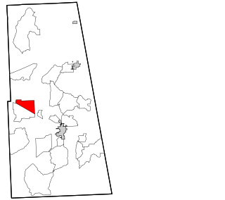
Zena is a census-designated place (CDP) in Delaware County, Oklahoma, United States, along State Highway 127. The population was 122 at the 2010 census. Established on Courthouse Prairie in District 5 of the old Indian Territory, its post office existed from April 11, 1896, until January 31, 1956.
White Oak is an unincorporated community and census-designated place (CDP) in Craig County, Oklahoma, United States, along State Highway 66, approximately one mile (1.6 km) west of that road's eastern terminus with U.S. Route 60. As of the 2010 census, the White Oak CDP had a population of 263. White Oak is the location of the Shawnee Tribe's annual Spring and Fall Bread Dances and Green Corn ceremonies.
Coleman is a small unincorporated community and census-designated place in Johnston County, Oklahoma, United States. The town was previously known as Ego, which was the name assigned to the post office when it was established in 1895. The post office name was officially changed to "Coleman" on September 10, 1910 due to a tornado that destroyed the town. The Census Bureau defined a census-designated place ("CDP") for Coleman in 2015; the 2010 population within the 2015 CDP boundary was 319 and contained 154 housing units. The population was 290 as of the 2020 Census. Coleman has its own schooling system and a bank plus 2 general stores.
Whitesboro is an unincorporated community and census-designated place (CDP) in Le Flore County, Oklahoma, United States. The population was 250 as of the 2010 census.
Albany is a census-designated place (CDP) and unincorporated community located in Bryan County, Oklahoma, United States, on State Highway 70E. The post office opened July 10, 1894. The community was named for Albany, New York. The population is 118 from the 2020 census, a decrease from 143 in 2010. The area code is 580.
Blanco is a rural unincorporated community located on State Highway 63 in Pittsburg County, Oklahoma, United States. The ZIP code is 74528. The Census Bureau defined a census-designated place (CDP) for Blanco in 2015; the 2010 population within the 2015 CDP boundary is 96 and contains 52 housing units.
Dale is an unincorporated community and census-designated place located on State Highway 270 in Pottawatomie County, Oklahoma, United States. It lies in the North Canadian River bottom, a few miles northwest of Shawnee. The population was 175 at the time of the 2020 Census, a slight decrease over the 2010 census figure of 186.
Grant is an unincorporated community in Choctaw County, Oklahoma, United States. It is located along U.S. Route 271, south of Hugo. As of the 2010 census it had a population of 289.
Blue is an unincorporated community and census-designated place in Bryan County, Oklahoma, United States. It is located 9 miles (14 km) east of Durant, the county seat. It is named after the nearby Blue River. As of the 2010 census it had a population of 195. Its post office was established on July 1, 1874.
Seward is an unincorporated community and census-designated place (CDP) in Logan County, Oklahoma, United States. Seward is 7 miles (11 km) south-southwest of Guthrie. Seward had a post office from May 15, 1889, to July 11, 1969. The community is named after William H. Seward.
Kenwood is an unincorporated community and census-designated place (CDP) in Delaware and Mayes counties, Oklahoma, United States. As of the 2010 census it had a population of 1,224.
Titanic is a census-designated place (CDP) in Adair County, Oklahoma, United States. The population was 356 at the 2010 census. It was presumably named after the famous ocean liner RMS Titanic.
Emet is an unincorporated community and census-designated place in Johnston County, Oklahoma, United States. The population was 69 as of the 2020 Census. A post office operated in Emet from 1884 to 1917. The Chickasaw have dwelt in Johnston County since the 1830s, and Emet's history reflects its Chickasaw heritage. Pleasant Grove Mission School, which was established by the Methodist Episcopal Church in 1844 and served the Chickasaw Nation, was located near Emet. Chickasaw actress and storyteller Te Ata Fisher was born in Emet in 1895.
Pontotoc is an unincorporated community and census-designated place in Johnston County, Oklahoma, United States. The population was 81 as of the 2020 Census. A post office was established in Pontotoc in 1858. The town was named after Pontotoc County, which was one of the divisions of the Chickasaw Nation.
Reagan is an unincorporated community and census-designated place in Johnston County, Oklahoma, United States. The population was 67 as of the 2020 Census. A post office operated in Reagan from 1894 to 1931. The town was named after John Henninger Reagan who was Postmaster General of the Confederate States of America.
Earl is an unincorporated community and census-designated place in Johnston County, Oklahoma, United States. The population was 44 as of the 2020 Census. A post office operated in Earl from 1893 to 1908.
Gowen is an unincorporated community and census-designated place (CDP) in Latimer County, Oklahoma, United States. The community is located to the south of U.S. Route 270 and 10 miles (16 km) west-southwest of Wilburton. Gowen has a post office with ZIP code 74545. The post office at Gowen, Indian Territory opened on January 13, 1894. The community was named for lawyer Francis I. Gowen. At the time of its founding, Gowen was located in the Moshulatubbee District of the Choctaw Nation.
Bee is an unincorporated community and census-designated place in Johnston County, Oklahoma, United States. The population was 135 as of the 2020 Census.


