Mannsville, Oklahoma

Last updated

Mannsville, Oklahoma
OKMap-doton-Mannsville.PNG
Location of Mannsville, Oklahoma
Coordinates: 34°11′07″N96°53′52″W / 34.18528°N 96.89778°W / 34.18528; -96.89778
Country United States
State Oklahoma
County Johnston
Area
[1]
  Total3.05 sq mi (7.91 km2)
  Land3.04 sq mi (7.86 km2)
  Water0.02 sq mi (0.05 km2)
Elevation
[2]
768 ft (234 m)
Population
 (2020)
  Total728
  Density239.87/sq mi (92.62/km2)
Time zone UTC-6 (Central (CST))
  Summer (DST) UTC-5 (CDT)
ZIP code
73447
Area code 580
FIPS code 40-46300 [3]
GNIS feature ID2412945 [2]

Mannsville is a town in Johnston County, Oklahoma, United States. The population was 863 at the 2010 census, [4] up from 587 in 2000.

Contents

Geography

Mannsville is located in southwestern Johnston County. It is bordered to the west by the town of Dickson in Carter County. As of 2010, the town had a total area of 3.3 square miles (8.5 km2), [4] more than triple its area in 2000. 0.02 square miles (0.06 km2), or 0.73% of the town's area, are water bodies. [4]

U.S. Route 177 passes through the center of Mannsville, leading west 6 miles (10 km) to the center of Dickson and southeast 10 miles (16 km) to Madill. Ardmore is 16 miles (26 km) west of Mannsville via Routes 177 and 199.

Mannsville has an all-volunteer fire department three stations, two in town and one in the small community of Greasy Bend.

Demographics

Historical population
CensusPop.Note
1900 198
1910 515160.1%
1920 63924.1%
1930 372−41.8%
1940 359−3.5%
1950 311−13.4%
1960 297−4.5%
1970 36422.6%
1980 56856.0%
1990 396−30.3%
2000 58748.2%
2010 86347.0%
2020 728−15.6%
U.S. Decennial Census [5]

As of the census [3] of 2000, there were 587 people, 221 households, and 150 families residing in the town. The population density was 543.8 inhabitants per square mile (210.0/km2). There were 253 housing units at an average density of 234.4 per square mile (90.5/km2). The racial makeup of the town was 81.77% White, 0.17% African American, 9.88% Native American, 0.34% from other races, and 7.84% from two or more races. Hispanic or Latino of any race were 0.51% of the population.

There were 221 households, out of which 33.0% had children under the age of 18 living with them, 51.1% were married couples living together, 13.1% had a female householder with no husband present, and 31.7% were non-families. 25.3% of all households were made up of individuals, and 10.0% had someone living alone who was 65 years of age or older. The average household size was 2.66 and the average family size was 3.25.

In the town, the population was spread out, with 26.6% under the age of 18, 8.3% from 18 to 24, 31.2% from 25 to 44, 21.6% from 45 to 64, and 12.3% who were 65 years of age or older. The median age was 36 years. For every 100 females, there were 100.3 males. For every 100 females age 18 and over, there were 95.0 males.

The median income for a household in the town was $24,896, and the median income for a family was $30,982. Males had a median income of $21,838 versus $18,676 for females. The per capita income for the town was $10,683. About 16.0% of families and 20.1% of the population were below the poverty line, including 24.9% of those under age 18 and 17.3% of those age 65 or over.

Related Research Articles

<span class="mw-page-title-main">Johnston County, Oklahoma</span> County in Oklahoma, United States

Johnston County is a county located in the U.S. state of Oklahoma. As of the 2020 census, the population was 10,272. Its county seat is Tishomingo. It was established at statehood on November 16, 1907, and named for Douglas H. Johnston, a governor of the Chickasaw Nation.

<span class="mw-page-title-main">Wales, Maine</span> Town in the state of Maine, United States

Wales is a town in Androscoggin County, Maine, United States. The population was 1,608 at the 2020 census. It is included in both the Lewiston-Auburn, Maine Metropolitan Statistical Area and the Lewiston-Auburn, Maine Metropolitan New England City and Town Area.

Medway is a town in Penobscot County, Maine, United States. The population was 1,187 at the 2020 census.

Mannsville is a village in the town of Ellisburg in Jefferson County, New York, United States. The population was 354 at the 2010 census, down from 400 in 2000. The name is from Barzillian Mann, early developer.

<span class="mw-page-title-main">Dickson, Oklahoma</span> Town in Oklahoma, United States

Dickson is a town in Carter County, Oklahoma, United States. The population was 1,207 at the 2010 census. It is part of the Ardmore, Oklahoma Micropolitan Statistical Area.

<span class="mw-page-title-main">Etowah, Oklahoma</span> Town in Oklahoma, United States

Etowah is a town in Cleveland County, Oklahoma, United States. The population was 159 at the 2020 census, a 72.8% increase from 2010.

<span class="mw-page-title-main">Ninnekah, Oklahoma</span> Town in Oklahoma, United States

Ninnekah is a town in Grady County, Oklahoma, United States. The population was 775 at the 2020 census, a 22.7% decrease from 2010.

<span class="mw-page-title-main">Ravia, Oklahoma</span> Town in Oklahoma, United States

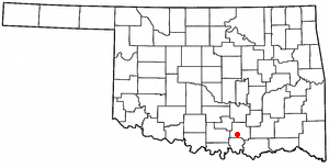
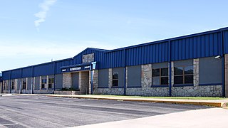
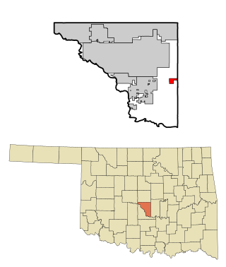
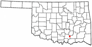
Ravia is a town in Johnston County, Oklahoma, United States. The population was 528 at the 2010 census, up from 459 in 2000.

<span class="mw-page-title-main">Tishomingo, Oklahoma</span> City in Oklahoma

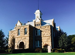
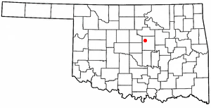
Tishomingo is the largest city in, and the county seat of, Johnston County, Oklahoma, United States. The population was 3,034 at the 2010 census, a decline of 4.1 percent from the figure of 3,162 in 2000. It was the first capital of the Chickasaw Nation, from 1856 until Oklahoma statehood in 1907. The city is home to Murray State College, a community college with an annual enrollment of 3,015 students. Tishomingo is part of the Texoma region.

<span class="mw-page-title-main">Wapanucka, Oklahoma</span> Town in Oklahoma, United States

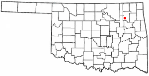
Wapanucka is a town in northeastern Johnston County, Oklahoma, United States. The population was 438 at the 2010 census, a 1.6 percent decrease from the figure of 445 in 2000. It is about 20 miles (32 km) northeast of Tishomingo. The town name refers to the Delaware Nation and means "Eastern Land People."

<span class="mw-page-title-main">Roosevelt, Oklahoma</span> Town in Oklahoma, United States

Roosevelt is a town in Kiowa County, Oklahoma, United States. The population was 248 at the 2010 census, a decline of 11.4 percent from 283 in 2000. The town was named for President Theodore Roosevelt.

<span class="mw-page-title-main">Carney, Oklahoma</span> Town in Oklahoma, United States

Carney is a town in Lincoln County, Oklahoma, United States. As of the 2020 census, the population of the town was 545.

<span class="mw-page-title-main">Davenport, Oklahoma</span> Town in Oklahoma, United States

Davenport is a town in Lincoln County, Oklahoma, United States. The population was 814 at the 2010 census.

<span class="mw-page-title-main">Lake Aluma, Oklahoma</span> Town in Oklahoma, United States

Lake Aluma is a town in Oklahoma County, Oklahoma, United States, and a part of the Oklahoma City Metropolitan Area. The population was 88 at the 2010 census.

<span class="mw-page-title-main">Tribbey, Oklahoma</span> Town in Oklahoma, United States

Tribbey is a town in Pottawatomie County, Oklahoma, United States.The community was named for Alpheus M. Tribbey, landowner. The population was 337 by the 2020 United States census.

<span class="mw-page-title-main">Valley Park, Oklahoma</span> Town in Oklahoma, United States

Valley Park is a town in Rogers County, Oklahoma, United States. The population was 77 at the 2010 census, up 221 percent from the figure of 24 recorded in 2000.

Dewey is a city in Washington County, Oklahoma, United States. The population was 3,179 at the 2000 census and 3,432 at the 2010 census, an increase of 8 percent. It is located near the north side of Bartlesville.

<span class="mw-page-title-main">Bancroft, West Virginia</span> Town in West Virginia, United States

Bancroft is a town in Putnam County, West Virginia, United States, along the Kanawha River. The population was 389 at the 2020 census. It is part of the Huntington–Ashland metropolitan area.

<span class="mw-page-title-main">Decatur, Wisconsin</span> Town in Wisconsin, United States

Decatur is a town in Green County, Wisconsin, United States. The population was 1,688 at the 2000 census.

<span class="mw-page-title-main">Stubbs, Wisconsin</span> Town in Wisconsin, United States

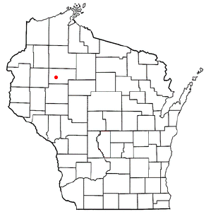
Stubbs is a town in Rusk County, Wisconsin, United States. The population was 587 at the 2000 census. The unincorporated community of Apollonia is located in the town.

References

  1. "ArcGIS REST Services Directory". United States Census Bureau. Retrieved September 20, 2022.
  2. 1 2 U.S. Geological Survey Geographic Names Information System: Mannsville, Oklahoma
  3. 1 2 "U.S. Census website". United States Census Bureau . Retrieved January 31, 2008.
  4. 1 2 3 "Geographic Identifiers: 2010 Census Summary File 1 (G001): Mannsville town, Oklahoma". American Factfinder. U.S. Census Bureau. Archived from the original on February 13, 2020. Retrieved October 19, 2018.
  5. "Census of Population and Housing". Census.gov. Retrieved June 4, 2015.