Related Research Articles
The British Columbia Hydro and Power Authority, operating as BC Hydro, is a Canadian electric utility in the province of British Columbia. It is the main electricity distributor, serving more than 4 million customers in most areas, with the exception of the City of New Westminster, where the city runs its own electrical department and portions of the West Kootenay, Okanagan, the Boundary Country and Similkameen regions, where FortisBC, a subsidiary of Fortis Inc. directly provides electric service to 213,000 customers and supplies municipally owned utilities in the same area. As a provincial Crown corporation, BC Hydro reports to the BC Ministry of Energy, Mines and Low Carbon Innovation, and is regulated by the British Columbia Utilities Commission (BCUC). Its mandate is to generate, purchase, distribute and sell electricity.
Mica Dam is a hydroelectric embankment dam spanning the Columbia River 135 kilometres north of Revelstoke, British Columbia, Canada. It was built as one of three Canadian projects under the terms of the 1964 Columbia River Treaty and is operated by BC Hydro. Completed in 1973, the Mica powerhouse had an original generating capacity of 1,805 megawatts (MW). Mica Dam, named after the nearby settlement of Mica Creek and its associated stream, in turn named after the abundance of mica minerals in the area, is one of the largest earthfill dams in the world. The reservoir created by the dam is Kinbasket Lake. Water from the dam flows south directly into Revelstoke Lake, the reservoir for the Revelstoke Dam. Mica Dam is the tallest dam in Canada and second tallest in North America after the Chicoasén Dam in Mexico and it is the farthest upstream dam on the Columbia River. The dam's underground powerhouse was the second largest in the world at the time of its construction, and was the first 500 kV installation of sulphur hexafluoride (SF6) insulated switchgear in the world.

Revelstoke Dam, also known as Revelstoke Canyon Dam, is a hydroelectric dam spanning the Columbia River, 5 km (3.1 mi) north of Revelstoke, British Columbia, Canada. The powerhouse was completed in 1984 and has an installed capacity of 2480 MW. Four generating units were installed initially, with one additional unit (#5) having come online in 2011. The reservoir behind the dam is named Lake Revelstoke. The dam is operated by BC Hydro.

The Mangla Dam is a multipurpose dam situated on the Jhelum River in the Mirpur District of Azad Kashmir, Pakistan. It is the sixth-largest dam in the world. The village of Mangla, which sits at the mouth of the dam, serves as its namesake. In November 1961, the project's selected contractors were revealed; it was announced that Binnie & Partners, a British engineering firm, was going to serve as the lead designers, engineers, and inspectors for the construction of the dam. The project was undertaken by a consortium known as the Mangla Dam Contractors, which consisted of eight American construction firms sponsored by the Guy F. Atkinson Company based in South San Francisco, California.

The Coquitlam River is a tributary of the Fraser River in the Canadian province of British Columbia. The river's name comes from the word Kʷikʷəƛ̓əm which translates to "Red fish up the river". The name is a reference to a sockeye salmon species that once occupied the river's waters.
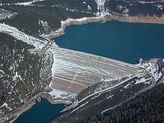
Coquitlam Lake is a reservoir located just north of Coquitlam, British Columbia. It is one of the three main water sources for Metro Vancouver, and part of the Coquitlam watershed. It is also a part of BC Hydro's power generation system. A tunnel directs water from the lake to nearby Buntzen Lake, and from there to a pair of power stations.
The Bridge River Power Project is a hydroelectric power development in the Canadian province of British Columbia, located in the Lillooet Country between Whistler and Lillooet. It harnesses the power of the Bridge River, a tributary of the Fraser, by diverting it through a mountainside to the separate drainage basin of Seton Lake, utilizing a system of three dams, four powerhouses and a canal.

Indian Arm is a steep-sided glacial fjord adjacent to the city of Vancouver in southwestern British Columbia. Formed during the last Ice Age, it extends due north from Burrard Inlet, between the communities of Belcarra and the District of North Vancouver, then on into mountainous wilderness. Burrard Inlet and the opening of Indian Arm was mapped by Captain George Vancouver and fully explored days later by Dionisio Alcalá Galiano in June 1792.

Great Falls Dam is a hydroelectric dam on the Caney Fork, straddling the county line between White County and Warren County in the U.S. state of Tennessee. It is the only dam outside the Tennessee River watershed owned and operated by the Tennessee Valley Authority. The dam impounds the 1,830-acre (740 ha) Great Falls Lake, and its tailwaters feed into Center Hill Lake. The completion of Great Falls Dam in late 1916 was an engineering triumph, marking the first successful attempt to impound the volatile and flood-prone Caney Fork. The dam is also notable for its design, utilizing a mostly underground conduit to carry water from the reservoir via a tributary to the Power House 0.75 miles (1.21 km) downstream from the dam.

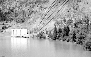
Buntzen Lake is a 4.8 kilometres (3 mi) long lake in Anmore, British Columbia, Canada, in the Greater Vancouver area. It is named after the first general manager of the B.C. Electric Co., Johannes Buntzen. There is a smaller lake just to the north named McCombe Lake.
Eagle Mountain, also known as Eagle Ridge, is the mountainous ridge with many indistinct summits between Buntzen Lake and Coquitlam Lake near Coquitlam, British Columbia. Its proximity to Coquitlam, and the houses being built on its southern slopes, make it a very popular weekend destination for hiking, mountain biking, horseback riding, and ATV riding. There is a network of logging roads leading up the south side of the summit to a plateau area with lakes, hiking trails and mountain biking trails.

The Jordan River Dam, officially the Jordan River Diversion Dam, and known locally simply as Diversion Dam, is a dam located in Jordan River, British Columbia, Canada. It is part of the second hydroelectric development on Vancouver Island.
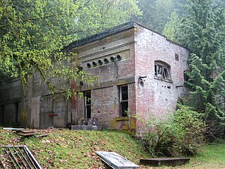
The Goldstream Powerhouse is a decommissioned hydroelectric plant located near Goldstream Provincial Park in Langford, near Victoria, British Columbia. This plant provided electricity to Victoria for 60 years and is one of the little-known and ingenious chapters in the history of Victoria. This plant was one of the first hydro plants of this type on the west coast of North America. The structure is over a century old and is unsafe to inhabit. It is within the boundaries of the watershed lands owned by the CRD and is inaccessible to the public due to its proximity to a drinking water reservoir.

Ruskin Dam is a concrete gravity dam on the Stave River in Ruskin, British Columbia, Canada. The dam was completed in 1930 for the primary purpose of hydroelectric power generation. The dam created Hayward Lake, which supplies water to a 105 MW powerhouse and flooded the Stave's former lower canyon, which ended in a small waterfall approximately where the dam is today.

Stave Falls Dam is a dual-dam power complex on the Stave River in Stave Falls, British Columbia, Canada. The dam was completed in 1912 for the primary purpose of hydroelectric power production. To increase the capacity of Stave Lake, the dam was raised in 1925 and the Blind Slough Dam constructed in an adjacent watercourse 500 m (1,600 ft) to the north, which was the site of the eponymous Stave Falls. In 2000, the dam's powerhouse was replaced after a four-year upgrade. The original Stave Falls powerhouse was once British Columbia's largest hydroelectric power source, and is a National Historic Site of Canada.

The Kootenay Canal is a hydroelectric power station, located 19 km downstream of Nelson, British Columbia, Canada. Where the Kootenay River flows out of the reservoir formed by the Corra Linn Dam on Kootenay Lake., a canal diverts water to BC Hydro's Kootenay Canal Generating Station. Its construction was a result of the Duncan Dam and Libby Dam providing year round flows into Kootenay Lake. The powerhouse was completed in 1976.
The John Hart Dam is one of three hydroelectric dams on the Campbell River, located on Vancouver Island in British Columbia, Canada. The dam is located at the outflow of John Hart Lake. The John Hart Generating Station is located nearby.
The Kemano Generating Station is situated 75 km (47 mi) southeast of Kitimat in the province of British Columbia, Canada. It was completed in 1954, providing hydroelectricity for Alcan's Kitimat Aluminum smelter. The powerhouse is built in a cavern created 427 m (1,400 ft) inside the base of Mt Dubose. It produces 896 MW of power from its eight generator units, each of which has a capacity of 112 MW. It was the largest producer in the province when it was built, and is now the fifth largest electrical plant in British Columbia.

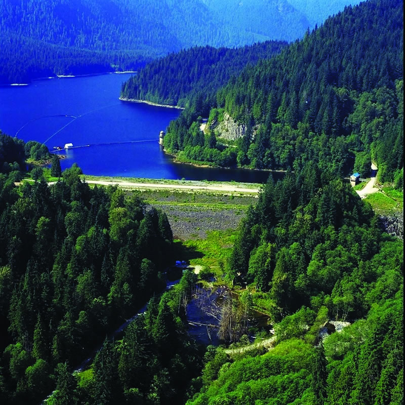
The Metro Vancouver watersheds, also known as the Greater Vancouver watersheds, supply potable water to approximately 2.7 million residents in the Lower Mainland of British Columbia. They provide tap water to a land area covering more than 2,600 square kilometres (1,000 sq mi), serving a total of 21 member municipalities, one electoral district, and one treaty First Nation. From west to east, the watersheds are the Capilano, the Seymour, and the Coquitlam. They are located in the North Shore Mountains and Coquitlam Mountain, respectively. Each watershed possesses a reservoir for water storage purposes, under the control of Metro Vancouver. The reservoirs are supplied by about 3.5 metres (11 ft) of rain and 4.5 metres (15 ft) of snowpack annually. Two additional off-catchment areas under control of Metro Vancouver contribute to the water supply. The watersheds have a long history of controversies surrounding logging, highway development, and salmon run conservation.
References
- ↑ BC Hydro: Coquitlam River and Buntzen Lake Watersheds Archived 2007-10-13 at the Wayback Machine Retrieved on 22 February 2009
- ↑ "Coquitlam Dam Emergency Flood Map" (PDF).
- 1 2 Will Koop: Coquitlam Watershed History Archived 2006-10-07 at the Wayback Machine Retrieved on 22 February 2009
- ↑ BC Hydro: Coquitlam Dam Seismic Upgrade Archived 2009-02-15 at the Wayback Machine Retrieved 12 March 2009