
Battle Creek is a river that begins in the south-eastern region of the Canadian province of Alberta, near the border with Saskatchewan, in the Cypress Hills Interprovincial Park. From Alberta, Battle Creek flows east and across the border into Saskatchewan. It flows south out of Saskatchewan across the Canada–United States border into Montana, where it joins the Milk River in Blaine County, Montana.

Poplar River is a tributary of the Missouri River, approximately 167 miles (269 km) long in Saskatchewan in Canada and Montana in the United States. The river is composed of three main forks – West, Middle, and East Poplar Rivers – that have their source in the Wood Mountain Hills of the Missouri Coteau. Along the river's Middle Fork in Saskatchewan, there is a coal-fired power station. There are also dams built along the river's forks.

Fort Peck Lake, or Lake Fort Peck, is a major reservoir in Montana, formed by the Fort Peck Dam on the Missouri River. The lake lies in the eastern prairie region of Montana approximately 140 miles (230 km) east of Great Falls and 120 miles (190 km) north of Billings, reaching into portions of six counties.
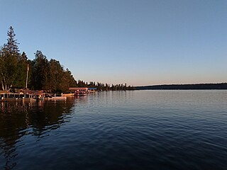
Emma Lake is a recreational lake in the Canadian province of Saskatchewan. It is located near the southern limit of the boreal forest, about 45 kilometres (28 mi) north of Prince Albert. The lake is within the District of Lakeland No. 521 and east of Prince Albert National Park. There are several small communities and recreational opportunities around Emma Lake and much of the northern half is within Great Blue Heron Provincial Park. Access to the lakes is from Highways 953, 952, and 263.
The Rural Municipality of Reno No. 51 is a rural municipality (RM) in the Canadian province of Saskatchewan within Census Division No. 4 and SARM Division No. 3. Located in the southwest corner of the province, it is adjacent to the United States border to the south and the Alberta boundary to the west.
The Frenchman River,, also known locally as the Whitemud River, is a river in Saskatchewan, Canada and Montana, United States. It is a tributary of the Milk River, itself a tributary of the Missouri and in turn a part of the Mississippi River watershed that flows to the Gulf of Mexico.

Sturgeon River is a river in the Hudson Bay drainage basin in the central part of the Canadian province of Saskatchewan. It flows from its source in the Waskesiu Hills in Prince Albert National Park to the North Saskatchewan River, just west of the city of Prince Albert.

Moose Mountain Lake is a reservoir in the Canadian province of Saskatchewan. It is located in the RM of Golden West No. 95 in the Prairies Ecozone of Palliser's Triangle at the western edge of Moose Mountain Upland. Moose Mountain Creek is both the primary inflow and outflow of the lake; it enters at the north end and leaves at the dam in the south end. A secondary inflow that comes from Gooseberry Lake enters on the western side near the south end.

Thunder Creek is a river in the Canadian province of Saskatchewan. The watershed of Thunder Creek is within the semi-arid Palliser's Triangle in south-central Saskatchewan. It begins at small, man-made reservoir near Lake Diefenbaker and flows in a south-easterly direction towards the city of Moose Jaw and the Moose Jaw River. The Moose Jaw River is a major tributary of the Qu'Appelle River For most of its course, Thunder Creek follows a valley called the Thunder Creek meltwater channel that was formed over 10,000 years ago near the end of the last ice age.

Oak Lake is a lake in the south-western part of the Canadian province of Manitoba in a region called Westman. Oak Lake is a kettle lake and is an aquifer supplier for numerous nearby residential areas and farms. The lake is in the RM of Sifton and sits at an elevation of 426 metres above sea level. Provincial Road 254 provides access to the lake.
Woody Lake is a lake in the Canadian province of Saskatchewan. It is located in the east-central part of the province in the Porcupine Hills and Porcupine Provincial Forest. The entire lake is in the Woody River Block of Porcupine Hills Provincial Park. Highway 980 provides access to the lake.
Theodore Reservoir is a man-made reservoir along the course of the Whitesand River in the Canadian province of Saskatchewan. The lake was formed with the building of Theodore Dam in 1964. The reservoir and dam were named after the nearby community of Theodore. Whitesand River is the primary inflow and outflow for the reservoir. Lawrie Creek, which begins in the Beaver Hills, flows into the lake on the western side near the dam.

Crescent Creek is a river in the south-east region of the Canadian province of Saskatchewan. The river begins in the Beaver Hills and flows in an easterly direction into Crescent Lake. Crescent Creek is a tributary of Yorkton Creek, which flows north into the Whitesand River–a tributary of the Assiniboine River.
Wood River is a river in the Canadian province of Saskatchewan. It has its source in the Wood Mountain Hills of south-western Saskatchewan and flows in a north-easterly direction to its mouth at Old Wives Lake. Old Wives Lake is a salt water lake with no outflow. As a result, the drainage basin of Wood River is an endorheic one. Along the course of the river, there are several parks, historical sites, and small towns.

Maple Creek is a river in the south-west region of the Canadian province of Saskatchewan. The river is in the semi-arid region known as Palliser's Triangle. It begins in the Cypress Hills and flows generally in a northward direction and empties into the endorheic Bigstick Lake. The town of Maple Creek is the only notable community along the course of the river. Due to the generally dry and drought-prone conditions of the area, reservoirs were built along the river's course and in its watershed to ensure a stable water supply for irrigation. Two Important Bird Areas (IBA) of Canada cover much of the lower watershed of the river.
Boggy Creek is a river in the Canadian province of Saskatchewan. The river begins north-east of Balgonie and heads in a westerly direction towards Pilot Butte and Regina before turning north-west where it meets the Qu'Appelle River east of Lumsden. Along the river's course there is a reservoir and several tourist attractions including parks, golf courses, a race track, and a summer camp.

Swift Current Creek is a river in the Canadian province of Saskatchewan. In the 1800s, Métis buffalo hunters called it Rivière au Courant. This name was also adopted by the North-West Mounted Police on their March West in 1874. In 1883, the name Swift Current Creek was first published on official maps by the Department of the Interior. The river begins at an elevation of over 1,100 metres (3,600 ft) in the Cypress Hills and flows in a north-easterly direction through valleys and coulees en route to Lake Diefenbaker of the South Saskatchewan River in the semi-arid region known as Palliser's Triangle. Notable communities along the river's course include Swift Current, Waldeck, and South Fork.
Bradwell Reservoir is a man-made reservoir in the Canadian province of Saskatchewan in the Rural Municipality of Blucher No. 343. The reservoir was built as part of the South Saskatchewan River Project. That project involved the damming of the South Saskatchewan River with the Gardiner and Qu'Appelle River Dams creating Lake Diefenbaker. From Lake Diefenbaker, a series of aqueducts were built allowing for irrigation and the creation of several reservoirs, including Bradwell Reservoir. The reservoir is owned and operated by the Saskatchewan Water Security Agency. Bradwell Reservoir supplies water to the Nutrien Allan Potash Mine near Allan.

Overflowing River is a river in the Canadian provinces of Manitoba and Saskatchewan. It begins in Saskatchewan at Overflow Lake in the Pasquia Provincial Forest and flows in a generally eastward direction into Manitoba and then Lake Winnipegosis. The river traverses boreal forests and muskeg in the Boreal Plains Ecozone, moving from the Mid-Boreal Upland of the Pasquia Hills east to the Mid-Boreal Lowland.

