Craiglie

Last updated

Craiglie
Queensland
Captain Cook Highway, Craiglie, 2015.JPG
Captain Cook Highway, Craiglie, 2015
Australia Queensland location map.svg
Red pog.svg
Craiglie
Coordinates 16°32′22″S145°27′49″E / 16.5394°S 145.4636°E / -16.5394; 145.4636 (Craiglie (centre of locality))
Postcode(s) 4877
Area14.0 km2 (5.4 sq mi)
Time zone AEST (UTC+10:00)
Location
LGA(s) Shire of Douglas
State electorate(s) Cook
Federal division(s) Leichhardt
Suburbs around Craiglie:
Killaloe Port Douglas Coral Sea
Cassowary Craiglie Coral Sea
Cassowary Mowbray Mowbray

Craiglie is a coastal rural locality in the Shire of Douglas, Queensland, Australia. [1] In the 2021 census, Craiglie had a population of 1,062 people. [2]

Contents

Geography

Sugar cane harvesting, Craiglie, 2015 Sugar cane harvesting, Craiglie, 2015 (03).JPG
Sugar cane harvesting, Craiglie, 2015

Craiglie is bounded by the Cassowary Range to the southwest, Mowbray River to the southeast and the Coral Sea to the east. The Captain Cook Highway and the cane tramway to the Mossman sugar mill form part of its boundary with Port Douglas to the north. [3]

Historically, Craiglie provided the connection between Port Douglas and The Bump Track which crossed the range. Although it no longer provides access over the range, it remains the access point to Port Douglas, where the Port Douglas Road joins the Captain Cook Highway and it remains a service centre for businesses serving the highway and Port Douglas as well as being an extension of the suburban areas in the south of Port Douglas. [3]

There is also farming on the low-lying coastal areas, principally sugarcane. [3]

History

As the motivation for the development of the port at Port Douglas was to transport gold from the Hodgkinson Minerals Area, in 1877 Christie Palmerston created the Bump Track which passed over the Cassowary Range from (present day) Mowbray to (present day) Julatten. Coming from Port Douglas, the teamsters would camp at the base of the range at Four Mile (as Craiglie was then known) before tackling "The Bump". A village formed there to supply services needed by the teamsters, such as hotels, a blacksmith, a saddlery, and a butcher shop. [4] The Bump Track was the only road access to Port Douglas until a coast road (now the Captain Cook Highway) was built to Cairns in 1933. [5] Today the Mossman Mount Molloy Road provides a range crossing from the Captain Cook Highway at Shannonvale/Cassowary to Julatten, [3] and The Bump Track is no longer in use (except for bushwalking and mountain biking). [6]

Craiglea State School opened in 1888 and closed in 1928. [7] [8] [9] [10]

Demographics

In the 2016 census, Craiglie had a population of 954 people. [11]

In the 2021 census, Craiglie had a population of 1,062 people. [2]

Education

There are no schools in Craiglie. The nearest government primary school is Port Douglas State School in neighbouring Port Douglas to the north. The nearest government secondary school is Mossman State High School in Mossman to the north-west. [3]

Related Research Articles

<span class="mw-page-title-main">Daintree National Park</span> Protected area in Queensland, Australia

The Daintree National Park is located in Far North Queensland, Australia, 1,757 km (1,092 mi) northwest of Brisbane and 100 km (62 mi) northwest of Cairns. It was founded in 1981 and is part of the Wet Tropics of Queensland. In 1988, it became a World Heritage Site. The park consists of two sections—Mossman Gorge and Cape Tribulation, with a settled agricultural area between them which includes the towns of Mossman and Daintree Village.

<span class="mw-page-title-main">Daintree, Queensland</span> Town in Queensland, Australia

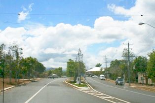
Daintree is a rural town and locality in the Shire of Douglas, Queensland, Australia. In the 2016 census, Daintree had a population of 129 people.

<span class="mw-page-title-main">Port Douglas</span> Town in Queensland, Australia

Port Douglas is a coastal town and locality in the Shire of Douglas, Queensland, Australia, approximately 60 km north of Cairns. In the 2016 census, Port Douglas had a population of 3,504 people. The town's population can often double, however, with the influx of tourists during the peak tourism season from May to September. The town is named in honour of a former Premier of Queensland, John Douglas. Port Douglas developed quickly based on the mining industry. Other parts of the area were established with timber cutting in the area surrounding the Daintree River and with settlement starting on lots around the Mossman River by 1880.

<span class="mw-page-title-main">Captain Cook Highway</span>

The Captain Cook Highway is a short, regional highway in Queensland which originates in Cairns and terminates in Mossman, where it joins Mossman-Daintree Road, continuing to Daintree. It is a state-controlled regional road.

<span class="mw-page-title-main">Cape Tribulation, Queensland</span> Suburb of Shire of Douglas, Queensland, Australia

Cape Tribulation is a headland and coastal locality in the Shire of Douglas in northern Queensland, Australia. In the 2021 census, Cape Tribulation had a population of 123 people.

<span class="mw-page-title-main">Mount Molloy, Queensland</span> Town in Queensland, Australia

Mount Molloy is a rural town and locality in the Shire of Mareeba, Queensland, Australia. It is a historic mining and timber town, 55 kilometres (34 mi) north of Cairns. The dominant industry in the area is cattle grazing; the town itself consists of a few shops and an old hotel.

<span class="mw-page-title-main">Mossman, Queensland</span> Town in Queensland, Australia

Mossman is a rural town and locality in the Shire of Douglas, Queensland, Australia. It is the administrative centre for the Douglas Shire Council In the 2016 census, the locality of Mossman had a population of 1,937 people.

<span class="mw-page-title-main">Bloomfield River</span> River in Far North Queensland, Australia

The Bloomfield River is a river in the Wet Tropics of Far North Queensland, Australia, noted for its Bloomfield River cod fish species, found only in the river.

<span class="mw-page-title-main">Bloomfield, Queensland</span> Suburb of Shire of Cook, Queensland, Australia

Bloomfield is a town in the Shire of Cook and a coastal locality which is split between the Shire of Cook and the Shire of Douglas in Queensland, Australia. The neighbourhood of Ayton is within the locality. In the 2016 census, Bloomfield had a population of 204 people.

<span class="mw-page-title-main">Palmer, Queensland</span> Suburb of Shire of Cook, Queensland, Australia

Palmer is a rural locality in the Shire of Cook, Queensland, Australia. In the 2021 census, Palmer had a population of 46 people.

<span class="mw-page-title-main">Mossman River</span> River in Far North Queensland, Australia

The Mossman River is a river in the Cape York Peninsula of Far North Queensland, Australia.

<span class="mw-page-title-main">Exchange Hotel, Mossman</span> Historic site in Queensland, Australia

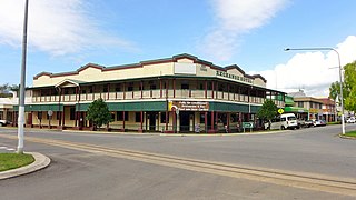
Exchange Hotel is a heritage-listed hotel at 2 Front Street, Mossman, Shire of Douglas, Queensland, Australia. It was designed by Vibert McKirdy Brown and built from 1934 to 1935. It was also known as Daintree Inn. It was added to the Queensland Heritage Register on 9 November 2012.

Bonnie Doon is a coastal rural locality in the Shire of Douglas, Queensland, Australia. In the 2021 census, Bonnie Doon had a population of 563 people.

Cassowary is a rural locality in the Shire of Douglas, Queensland, Australia. In the 2016 census Cassowary had a population of 119 people.

<span class="mw-page-title-main">Wangetti, Queensland</span> Town in Queensland, Australia

Wangetti is a coastal town and a locality in the Shire of Douglas, Queensland, Australia.

Mowbray is a coastal locality in the Shire of Douglas, Queensland, Australia. In the 2016 census, Mowbray had a population of 321 people.

Killaloe is a coastal rural locality in the Shire of Douglas, Queensland, Australia. In the 2016 census, Killaloe had a population of 116 people.

<span class="mw-page-title-main">Macalister Range, Queensland</span> Suburb of Cairns Region, Queensland, Australia

Macalister Range is a coastal locality in the Cairns Region, Queensland, Australia. In the 2016 census, Maclister Range had no population.

<span class="mw-page-title-main">Oak Beach, Queensland</span> Town in Queensland, Australia

Oak Beach is a coastal town and locality in the Shire of Douglas, Queensland, Australia. In the 2016 census, the locality of Oak Beach had a population of 195 people.

Finlayvale is a rural locality in the Shire of Douglas, Queensland, Australia. In the 2021 census, Finlayvale had a population of 33 people.

References

  1. "Craiglie – locality in Shire of Douglas (entry 48591)". Queensland Place Names. Queensland Government . Retrieved 29 December 2017.
  2. 1 2 Australian Bureau of Statistics (28 June 2022). "Craiglie (SAL)". 2021 Census QuickStats. Retrieved 28 February 2023. OOjs UI icon edit-ltr-progressive.svg
  3. 1 2 3 4 5 "Queensland Globe". State of Queensland . Retrieved 1 September 2023.
  4. "PATHWAYS OF YESTERDAY". The Northern Herald . Vol. 105, no. 1365. Queensland, Australia. 10 June 1939. p. 14. Retrieved 27 November 2018 via National Library of Australia.
  5. "Brief History Of Mowbray, Far North Queensland". Douglas Shire Historical Society . Retrieved 27 November 2018.
  6. "The Bump Track". Port Douglas Historical Society . Retrieved 27 November 2018.
  7. Queensland schools past and present (Version 1.01 ed.), Queensland Family History Society, 2010, ISBN   978-1-921171-26-0
  8. "Port Douglas". The Week . Vol. XXII, no. 565. Queensland, Australia. 23 October 1886. p. 23. Retrieved 1 September 2023 via National Library of Australia.
  9. "Port Douglas". The Week . Vol. XXIV, no. 609. Queensland, Australia. 27 August 1887. p. 25. Retrieved 1 September 2023 via National Library of Australia.
  10. "THE EDUCATION DEPARTMENT". The Brisbane Courier . Vol. XLV, no. 9, 514. Queensland, Australia. 12 July 1888. p. 6. Retrieved 1 September 2023 via National Library of Australia.
  11. Australian Bureau of Statistics (27 June 2017). "Craiglie (SSC)". 2016 Census QuickStats. Retrieved 20 October 2018. OOjs UI icon edit-ltr-progressive.svg

Further reading