
The Daintree National Park is located in Far North Queensland, Australia, 1,757 km (1,092 mi) northwest of Brisbane and 100 km (62 mi) northwest of Cairns. It was founded in 1981 and is part of the Wet Tropics of Queensland. In 1988, it became a World Heritage Site. The park consists of two sections—Mossman Gorge and Cape Tribulation, with a settled agricultural area between them which includes the towns of Mossman and Daintree Village.

Daintree is a rural town and locality in the Shire of Douglas, Queensland, Australia. In the 2016 census, Daintree had a population of 129 people.

Cape Tribulation is a headland and coastal locality in the Shire of Douglas in northern Queensland, Australia. In the 2016 census, Cape Tribulation had a population of 118 people.

Mossman is a rural town and locality in the Shire of Douglas, Queensland, Australia. It is the administrative centre for the Douglas Shire Council In the 2016 census, the locality of Mossman had a population of 1,937 people.

The Shire of Cook is a local government area in Far North Queensland, Australia. The Shire covers most of the eastern and central parts of Cape York Peninsula, the most northerly section of the Australian mainland.

Wonga Beach is a coastal locality in the Shire of Douglas, Queensland, Australia. The town of Wonga is within the locality. In the 2016 census, Wonga Beach had a population of 975 people.
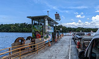
The Daintree River Ferry is a cable ferry across the Daintree River between the localities of Forest Creek and Lower Daintree in the Shire of Douglas, Queensland, Australia. The ferry is situated some 50 kilometres (31 mi) north of Port Douglas, and gives access to the northern section of the Daintree National Park and to Cape Tribulation. The ferry provides the only sealed road access to this area.

The Wujal Wujal Aboriginal Shire is a local government area in Far North Queensland, Australia. It is managed as a Deed of Grant in Trust under the Local Government Act 2004.

Bloomfield is a town in the Shire of Cook and a coastal locality which is split between the Shire of Cook and the Shire of Douglas in Queensland, Australia. The neighbourhood of Ayton is within the locality. In the 2016 census, Bloomfield had a population of 204 people.

Palmer is a rural locality in the Shire of Cook, Queensland, Australia. In the 2021 census, Palmer had a population of 46 people.

The Mossman River is a river in the Cape York Peninsula of Far North Queensland, Australia.

Miallo is a rural locality in the Shire of Douglas, Queensland, Australia. In the 2016 census, Miallo had a population of 376 people.

Cow Bay is a coastal locality in the Shire of Douglas, Queensland, Australia. In the 2021 census, Cow Bay had a population of 220 people.

Whyanbeel is a rural locality in the Shire of Douglas, Queensland, Australia. In the 2016 census, Whyanbeel had a population of 160 people.

Rocky Point is a coastal rural locality in the Shire of Douglas, Queensland, Australia. In the 2016 census, Rocky Point had a population of 129 people.

Newell is a coastal town and rural locality in the Shire of Douglas, Queensland, Australia. It is a sugarcane growing district.
Cooya Beach is a coastal town and locality in the Shire of Douglas, Queensland, Australia. In the 2016 census, the locality of Cooya Beach had a population of 546 people.
Diwan is a coastal locality in the Shire of Douglas, Queensland, Australia. In the 2021 census, Diwan had a population of 169 people.

Lower Daintree is a coastal rural locality in the Shire of Douglas, Queensland, Australia. In the 2021 census, Lower Daintree had a population of 83 people.

Kimberley is a coastal locality in the Shire of Douglas, Queensland, Australia. In the 2021 census, Kimberley had a population of 28 people.


