Crookwell, New South Wales

Last updated

Crookwell
New South Wales
Crookwell 1.jpg
Crookwell
Australia New South Wales location map blank.svg
Red pog.svg
Crookwell
Crookwell, New South Wales
Coordinates 34°27′29″S149°28′13″E / 34.458036°S 149.470283°E / -34.458036; 149.470283
Population2,098 (UCL 2021) [1]
Postcode(s) 2583
Elevation887 m (2,910 ft)
Location
LGA(s) Upper Lachlan Shire
Region Southern Tablelands
County King
Parish Crookwell
State electorate(s) Goulburn
Federal division(s) Hume
Mean max tempMean min tempAnnual rainfall
18.2 °C
65 °F
5.0 °C
41 °F
863.8 mm
34 in
Localities around Crookwell:
Binda Laggan Laggan
Lost River Crookwell Roslyn
Grabben Gullen Bannister Pejar

Crookwell is a small town located in the Southern Tablelands of New South Wales, Australia, in the Upper Lachlan Shire. [2] At the 2016 census, Crookwell had a population of 2,641. [3] The town is at a relatively high altitude of 887 metres and there are several snowfalls during the cooler months. The nearest major centre is the city of Goulburn which is about a half-hour drive to the south-east of the town. Crookwell is easily accessible to the state capital of Sydney and also the federal capital of Canberra.

Contents

Most employment is based on rural industries, and the district is renowned for potato farming. Crookwell is also home to what was NSW's first wind farm, which consists of 8 turbines, and is located a few kilometres out of town on the road towards Goulburn.

A railway once connected Goulburn and Crookwell, which opened in 1902, but passenger services to Crookwell station ceased in 1974, [4] [5] and the last goods train ran in 1985. The line is technically not closed, but has been listed as out of use, and in some locations is now impassable.

History

The area now known as Crookwell lies within the traditional lands of the Gundangurra people. These people spoke a similar if not identical language to the neighbouring Ngunnawal people to their south. [6]

The first Europeans known to be in the area were the exploratory party of surveyor James Meehan which camped 1 km south of present-day Grabben Gullen (12 km south-west of Crookwell). John Oxley passed to the north and east later that same year. Crookwell was originally known as "Kiama" but later renamed after the river. [7] The area around Crookwell was first settled in the 1820s, and had received its current name by the 1860s.

By 1840, some inns had appeared at the crossroads, but Binda remained the head of the district. [8] After this, selection of blocks occurred; and the population of was over 100 by midway through that decade. The first allotments were sold at the end of the decade. By the mid-1870s the population had already reached 1000 people. [9]

In 1865, Mary Gilmore was born just 16 km south in the town or Roslyn. [8]

From 1941 to 1945, 508,500 tons of iron ore was mined—about six miles by road from the town—and railed to Port Kembla for wartime steel production. [10] [11] [12] [13]

Crookwell contained one of Australias first wind farms, the Crookwell Wind Farm and the first wind farm that fed into the national power grid. [14]

Heritage listings

Crookwell has a number of heritage-listed sites, including:

Population

In the 2021 Census, there were 2,686 people in Crookwell. [16] In the 2016 census 85.8% of people were born in Australia and 91.4% of people spoke only English at home. The most common responses for religion were Catholic 34.9%, Anglican 30.1%, No Religion 14.3% and Uniting Church 7.8%. [3]

Governance

Crookwell is the seat of the Upper Lachlan Shire Council local government area (LGA) of New South Wales, Australia, formed in 2004.

Transport

Crookwell is approximately 2.5 hours drive from Sydney via Goulburn, and 1.5 hours from Canberra. Other than the main road to Goulburn, minor roads link Crookwell with Bathurst, Boorowa, Grabben Gullen, Laggan, and Taralga.

Crookwell railway station is the terminus of the now disused Crookwell railway line.

Crookwell has a small unpaved airstrip approximately 5 km south of the town. [17]

Climate

Owing to its exposed western location on the upwind side of the Great Dividing Range and rather southern latitude, snow is not uncommon during the winter months, with occasional heavy falls. Summers are warm and dry, with cool to cold nights. Winters are cold and wet; when the prevailing westerly cloud is persistent, daily maximum temperatures can struggle to exceed 3 °C (37 °F).

Climate data for Crookwell Post Office (1916–1975, rainfall 1883–2022); 887 m AMSL; 34.46° S, 149.47° E
MonthJanFebMarAprMayJunJulAugSepOctNovDecYear
Record high °C (°F)38.0
(100.4)
37.9
(100.2)
32.8
(91.0)
28.3
(82.9)
27.2
(81.0)
17.8
(64.0)
18.5
(65.3)
20.6
(69.1)
26.7
(80.1)
29.4
(84.9)
36.6
(97.9)
35.6
(96.1)
38.0
(100.4)
Mean daily maximum °C (°F)26.5
(79.7)
25.9
(78.6)
23.6
(74.5)
18.4
(65.1)
13.9
(57.0)
10.3
(50.5)
9.5
(49.1)
11.0
(51.8)
14.7
(58.5)
18.3
(64.9)
21.4
(70.5)
25.0
(77.0)
18.2
(64.8)
Mean daily minimum °C (°F)10.7
(51.3)
10.7
(51.3)
8.8
(47.8)
5.0
(41.0)
2.3
(36.1)
0.6
(33.1)
−0.4
(31.3)
0.3
(32.5)
2.1
(35.8)
4.6
(40.3)
6.7
(44.1)
9.0
(48.2)
5.0
(41.1)
Record low °C (°F)2.5
(36.5)
3.9
(39.0)
−0.6
(30.9)
−2.9
(26.8)
−7.2
(19.0)
−8.3
(17.1)
−9.2
(15.4)
−7.2
(19.0)
−5.0
(23.0)
−3.3
(26.1)
−0.6
(30.9)
0.6
(33.1)
−9.2
(15.4)
Average precipitation mm (inches)69.7
(2.74)
54.7
(2.15)
59.3
(2.33)
57.5
(2.26)
65.9
(2.59)
88.5
(3.48)
84.3
(3.32)
89.9
(3.54)
74.9
(2.95)
76.7
(3.02)
68.0
(2.68)
67.4
(2.65)
863.8
(34.01)
Average precipitation days (≥ 0.2 mm)7.06.36.97.09.211.912.111.710.29.38.07.0106.6
Source: Australian Bureau of Meteorology; Crookwell Post Office

Media

Radio stations

Radio stations with transmitters located in Crookwell include:

Depending on location some Goulburn, Illawarra, and/or Canberra based radio stations can also be heard. Eagle FM and GNFM (formerly 2GN) are Goulburn based but licensed to serve towns in the Southern Tablelands including Crookwell. In order to reach Crookwell, both have transmitters which relay the Goulburn broadcast but on different frequencies to Goulburn.

Television

Crookwell has a low powered transmitter broadcasting ABC Television.

Residents wishing to receive a wider range of channels and in digital can attempt to receive signals from either Canberra (Black Mountain), or Orange (Mount Canobolas), although Crookwell is located in the fringe area of both transmitters.

Another option is to use the VAST free-to-view satellite service, which offers a similar range of channels.

Newspaper

The local newspaper, the Crookwell Gazette has been published since 1885.

Notable people

Notable people include Kellie White and Emily Smith (Hockeyroos Captain), who both played for the Hockeyroos in international competition, Mary Douven, a notable community volunteer who gave her time to help the local sporting communities and church groups, who unfortunately died in 2020 one year to the day after her husband Theo Douven, who was a long term employee of the local Upper Lachlan Shire Council.

See also

Related Research Articles

<span class="mw-page-title-main">Goulburn</span> City in New South Wales, Australia

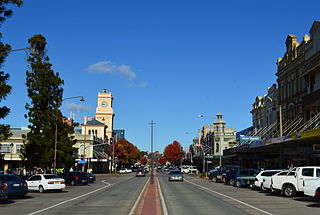
Goulburn is a regional city in the Southern Tablelands of the Australian state of New South Wales, approximately 195 kilometres (121 mi) south-west of Sydney, and 90 kilometres (56 mi) north-east of Canberra. It was proclaimed as Australia's first inland city through letters patent by Queen Victoria in 1863. Goulburn had a population of 23,835 at June 2018. Goulburn is the seat of Goulburn Mulwaree Council.

<span class="mw-page-title-main">Cooma</span> Town in New South Wales, Australia

Cooma is a town in the south of New South Wales, Australia. It is located 114 kilometres (71 mi) south of the national capital, Canberra, via the Monaro Highway. It is also on the Snowy Mountains Highway, connecting Bega with the Riverina.

<span class="mw-page-title-main">Upper Lachlan Shire</span> Local government area in New South Wales, Australia

Upper Lachlan Shire is a local government area in the Southern Tablelands region of New South Wales, Australia. The Shire was formed in February 2004 from Crookwell Shire and parts of Mulwaree, Gunning and Yass Shires.

<span class="mw-page-title-main">Gunning, New South Wales</span> Town in New South Wales, Australia

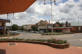
Gunning is a small town on the Old Hume Highway, between Goulburn and Yass in the Southern Tablelands of New South Wales, Australia, about 260 km south-west of Sydney and 75 km north of the national capital, Canberra.

<span class="mw-page-title-main">Taralga</span> Town in New South Wales, Australia

Taralga is the traditional land of the Gundungurra people. Today it is a small village in the Southern Tablelands of New South Wales, Australia, in Upper Lachlan Shire. It is located at the intersection of the Goulburn-Oberon Road and the Laggan-Taralga Road. It is accessible from Oberon to the north, Mittagong to the east, Goulburn to the south, and Crookwell to the west. At the 2016 census, Taralga had a population of 467. Taralga is located relatively close to the famous Wombeyan Caves. The town experiences a volatile climate and is sometimes affected by snow in the winter months.

<span class="mw-page-title-main">Breadalbane, New South Wales</span> Town in New South Wales, Australia

Breadalbane is a small village located in the Southern Tablelands of New South Wales, Australia in Upper Lachlan Shire. It is located on the Lachlan River headwaters and not far from Goulburn. At the 2021 census, Breadalbane had a population of 107.

<span class="mw-page-title-main">Dalton, New South Wales</span> Town in New South Wales, Australia

Dalton is a small inland country town in the Southern Tablelands of New South Wales, Australia, in Upper Lachlan Shire. The population was 230 in the 2021 census.

<span class="mw-page-title-main">Division of Hume</span> Australian federal electoral division

The Division of Hume is an Australian electoral division in the state of New South Wales.

<span class="mw-page-title-main">Goulburn railway station</span> Railway station in New South Wales, Australia

Goulburn railway station is a heritage-listed railway station on the Main South line in New South Wales, Australia. Opened on 19 May 1869, it serves the city of Goulburn. It was added to the New South Wales State Heritage Register on 2 April 1999.

<span class="mw-page-title-main">Electoral district of Burrinjuck</span> Former state electoral district of New South Wales, Australia (1950–2015)

Burrinjuck was an electoral district of the Legislative Assembly in the Australian state of New South Wales from 1950 to 2015.

<span class="mw-page-title-main">Tarago, New South Wales</span> Town in New South Wales, Australia

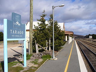
Tarago is a town in the Southern Tablelands of New South Wales, Australia in Goulburn Mulwaree Council. Part of the defined locality, which includes a large area of grazing country, is on the eastern shore of Lake George in the area of the Queanbeyan–Palerang Regional Council. The town is situated 39 kilometres south of the city of Goulburn and 69 kilometres northeast of Canberra, the capital city of Australia. It is located on the Goulburn-Braidwood road. The town is notable for recent renewable energy projects in the surrounding districts.

<span class="mw-page-title-main">Crookwell railway station</span> Historic site in New South Wales, Australia

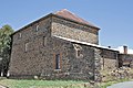
The Crookwell railway station is a heritage-listed former railway station and now museum on the Goulburn-Crookwell branch line, Crookwell, Upper Lachlan Shire, New South Wales, Australia. The property is owned by the Transport Asset Holding Entity, an agency of the Government of New South Wales. It was added to the New South Wales State Heritage Register on 2 April 1999. It is under the care of the Goulburn Crookwell Heritage Railway Inc.

<span class="mw-page-title-main">Taralga railway line</span> Former railway line in New South Wales

The Taralga railway line is a disused branch railway line in the south of New South Wales, Australia. The line commenced at a junction with the Goulburn to Crookwell line at Roslyn station and ran for a distance of 25.30 km (15.72 mi) to the small town of Taralga. The line operated between 1926 and 1957 and is one of few lines in New South Wales that has been formally closed by an Act of Parliament. Today all track has been lifted and little trace remains of the infrastructure associated with the line.

<span class="mw-page-title-main">Grabben Gullen</span> Town in New South Wales, Australia

Grabben Gullen is a small village in Upper Lachlan Shire, New South Wales, Australia. At the 2016 census, it had a population of 253. It is located between Crookwell and Gunning, situated at an elevation of 898 metres above sea level; several snowfalls occur during the winter months.

The Argyle Liberal and District Recorder was an English language newspaper published two times per week, on Tuesdays and Fridays, in Crookwell, New South Wales, Australia.

<span class="mw-page-title-main">Jerrawa</span> Town in New South Wales, Australia

Jerrawa is a locality in the Upper Lachlan Shire, New South Wales, Australia. It lies on the north side of the Hume Highway about 30 km to the east of Yass and was served by Jerrawa railway station on the Main Southern line between Sydney and Melbourne between 1876 and 1975. At the 2016 census, it had a population of 73.

<span class="mw-page-title-main">Gurrundah</span> Town in New South Wales, Australia

Gurrundah is a locality in the Upper Lachlan Shire, New South Wales, Australia. It lies on the eastern side of the Crookwell–Gunning road about 22 south of Crookwell and 26 km north of Gunning. At the 2016 census, it had a population of 55. The Gullen Range Wind Farm lies in the east of the locality above the upper Wollondilly River.

<span class="mw-page-title-main">Roslyn, New South Wales</span> Town in New South Wales, Australia

Roslyn is a locality in the Upper Lachlan Shire, New South Wales, Australia. It lies about 20 km east of Crookwell and 37 km north of Goulburn. At the 2016 census, it had a population of 92. Roslyn railway station was a junction station on the now disused Crookwell railway line from 1902 to 1974 and the disused Taralga railway line from 1926 to 1957.

<span class="mw-page-title-main">Woodhouselee, New South Wales</span> Town in New South Wales, Australia

Woodhouselee is a locality in the Upper Lachlan Shire, New South Wales, Australia. It lies about 25 km northwest of Goulburn and 115 km northeast of Canberra. At the 2016 census, it had a population of 15.

<span class="mw-page-title-main">Bannister, New South Wales</span> Town in New South Wales, Australia

Bannister is a locality in the Upper Lachlan Shire, New South Wales, Australia. It lies about 20 km south of Crookwell and 90 km northeast of Canberra. At the 2016 census, it had a population of 120.

References

  1. Australian Bureau of Statistics (28 June 2022). "Crookwell (urban centre and locality)". Australian Census 2021.  OOjs UI icon edit-ltr-progressive.svg
  2. "Crookwell". Geographical Names Register (GNR) of NSW. Geographical Names Board of New South Wales . Retrieved 2 August 2017. OOjs UI icon edit-ltr-progressive.svg
  3. 1 2 Australian Bureau of Statistics (27 June 2017). "Crookwell (State Suburb)". 2016 Census QuickStats. Retrieved 7 July 2017. OOjs UI icon edit-ltr-progressive.svg
  4. Scrymgeour, R. A History of the Goulburn- Crookwell Line. Australian Railway Historical Society Bulletin. Vol 48, no 721. November 1997.
  5. Crookwell station. NSWrail.net, accessed 21 August 2009.
  6. Studies, Australian Institute of Aboriginal and Torres Strait Islander (6 September 2021). "Map of Indigenous Australia". aiatsis.gov.au. Retrieved 12 June 2021.
  7. "Crookwell". The Sydney Morning Herald. 8 February 2004. Archived from the original on 19 September 2007. Retrieved 6 July 2017.
  8. 1 2 "Crookwell". The Sydney Morning Herald. 8 February 2004. Retrieved 23 February 2023.
  9. A Snapshot of Crookwell's History Archived 22 April 2011 at the Wayback Machine . Upper Lachlan Shire Council, accessed 20 September 2011.
  10. Anonymous (21 June 2015). "A Snapshot of Crookwell's History". www.upperlachlan.nsw.gov.au. Retrieved 20 September 2020.
  11. "IRON ORE". Goulburn Evening Post (NSW : 1940 - 1954). 26 March 1942. p. 3. Retrieved 20 September 2020.
  12. "IRON ORE". Yass Tribune-Courier (NSW : 1929 - 1954). 12 January 1942. p. 1. Retrieved 20 September 2020.
  13. "Crookwell mine (Crookwell iron deposit; Crookwell base metal prospect), Crookwell, King Co., New South Wales, Australia". www.mindat.org. Retrieved 12 June 2021.
  14. "Crookwell, NSW". Aussie Towns. Retrieved 23 February 2023.
  15. "Crookwell Railway Station and yard group". New South Wales State Heritage Register . Department of Planning & Environment. H01124. Retrieved 18 May 2018. CC BY icon.svg Text is licensed by State of New South Wales (Department of Planning and Environment) under CC-BY 4.0 licence .
  16. "2021 Crookwell, Census All persons QuickStats | Australian Bureau of Statistics". abs.gov.au. Retrieved 23 February 2023.
  17. YCRL – CROOKWELL  (PDF). AIP En Route Supplement from Airservices Australia , effective 2023-11-30