Fair Haven is a village located on the southern shore of Lake Ontario in Cayuga County, New York, United States. As of the 2020 census, its population was 760. Fair Haven is within the town of Sterling and is northwest of Syracuse. The village is on Little Sodus Bay, an arm of Lake Ontario.

The Toronto Islands are a chain of 15 small islands in Lake Ontario, south of mainland Toronto, Ontario, Canada.
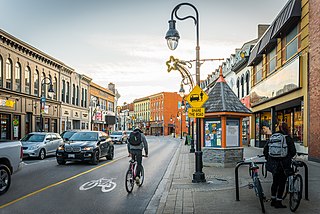
St. Catharines is the most populous city in Canada's Niagara Region, the eighth largest urban area in the province of Ontario. As of 2017, St. Catharines has an area of 96.13 square kilometres (37.12 sq mi) and 140,370 residents. It lies in Southern Ontario, 51 kilometres (32 mi) south of Toronto across Lake Ontario, and is 19 kilometres (12 mi) inland from the international boundary with the United States along the Niagara River. It is the northern entrance of the Welland Canal. Residents of St. Catharines are known as St. Catharinites. St. Catharines carries the official nickname "The Garden City" due to its 1,000 acres (4 km2) of parks, gardens, and trails.
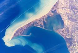
Long Point is a sand spit and medium-sized hamlet on the north shore of Lake Erie, part of Norfolk County in the province of Ontario, Canada.

Fort Erie is a town on the Niagara River in Niagara Region, Ontario, Canada. It is directly across the river from Buffalo, New York, and is the site of Old Fort Erie which played a prominent role in the War of 1812.

The Regional Municipality of Niagara, also colloquially known as the Niagara Region or Region of Niagara, is a regional municipality comprising twelve municipalities of Southern Ontario, Canada. The regional seat is in Thorold. It is the southern end of the Golden Horseshoe, the largest megalopolis in Canada.

Wasaga Beach is a town in Simcoe County, Ontario, Canada. Situated along the longest freshwater beach in the world, it is a popular summer tourist destination. It is located along the southern end of Georgian Bay, approximately 150 km (93 mi) north of Toronto and about 40 km (25 mi) northwest of Barrie. To the west, Collingwood and The Blue Mountains also attract visitors much of the year. The town is situated along a very long sandy beach on Nottawasaga Bay in Georgian Bay and the winding Nottawasaga River. The beaches are part of the Wasaga Beach Provincial Park; the park area totals 168 hectares. Wasaga Beach has a year-round population of 24,862 as of 2021, but during the summer months the population increases with many seasonal residents.
Ridgeway is a small, unincorporated village in Fort Erie, Ontario, Canada. The community is within the Niagara Regional Municipality. It used to be the seat of government for Bertie Township within Welland County. Ridgeway is now a part of the Town of Fort Erie. In recent years the rail line has been converted to a walking and cycling trail, part of a trail system circling the Niagara region.
Sauble Beach is a beach community and unincorporated area in the town of South Bruce Peninsula, Bruce County, in the northern area of southwestern Ontario, Canada. It is on the Bruce Peninsula, along the eastern shore of Lake Huron, on the north edge of the Saugeen First Nation. The beach takes its name from that given by early French explorers to the sandy Sauble River, originally "La Rivière Au Sable" also indicating that the river emptied into Lake Huron at a sandy beach. The river was labelled with the French name on maps until 1881, when it became the Sauble River; in early years, a sawmill was built on the river, and later, a hydro electric plant.

Rondeau Provincial Park is the second oldest provincial park in Ontario, Canada, having been established with an order in council on 8 September 1894. The park is located in Southwestern Ontario, on an 8 km long crescentic sand spit extending into Lake Erie. Rondeau is home to the largest area of Carolinian forest in Canada, a long sand beach, a large marsh, approximately half of Rondeau Bay, campgrounds and a cottage community. The name of the park comes from the French words "ronde eau" or "round water" which describes the shape of the harbour sheltered by the peninsula.

Britannia is a group of neighbourhoods in Bay Ward in the west end of Ottawa, Ontario, Canada. It is located on the Ottawa River across from Aylmer, Quebec, adjacent to its namesake, Britannia Bay, north of Richmond Road, west of the Kichi Zibi Mikan and east of Boyce Avenue. The total population of this area was 6,692 as of the 2016 census. The area constituted a municipal ward from 1973 to 1994.

Fort Erie Transit used to provide local accessible bus service to the inhabitants of Fort Erie, Ontario, Canada, just across the Peace Bridge and the Niagara River from Buffalo, New York.

The SS Canadiana was a passenger excursion steamer that primarily operated between Buffalo, New York, US, and the Crystal Beach Park in Crystal Beach, Ontario, Canada, from 1910 to 1956. Canadiana was the last passenger vessel built in Buffalo, New York.

Beach Boulevard is a Lower city street in Hamilton, Ontario, Canada, east of the Hamilton Harbour on a thin piece of land that crosses over Lake Ontario and stretches from where Woodward Avenue becomes Eastport Drive in the south to near the Lift Bridge in the north at Eastport Drive (again). It runs parallel with the QEW and the Burlington Bay James N. Allan Skyway Bridge.

Crystal Beach Park was an amusement park in Crystal Beach, Ontario from 1888 to 1989. It was serviced by the Canadiana passenger ferry in Buffalo, making it a popular tourist destination for both Canadians and Americans.

Bayfront Park is a 16-hectare (40-acre) park found in the West-end of Hamilton Harbour in the North End neighbourhood of Hamilton, Ontario, Canada.

Crystal Beach is an unincorporated community in the census-designated place of Palm Harbor in Pinellas County, Florida, United States. Crystal Beach is one of the original communities in Pinellas County. The first settlers came to the area and began homesteading around 1850. It was initially called the town of Seaside and the Orange Belt Railway was completed in the Spring of 1888 and connected the town of Seaside North to Tarpon Springs and South to Dunedin, Clearwater and St. Petersburgh.
Crystal Beach Hill is a geologically old and natural sand dune, fifty feet high and originally about two thousand feet long, parallel to the shoreline of Crystal Beach on the south-eastern shore of Lake Erie, in the town of Fort Erie, Ontario. The Hill and beach were originally a part of the Crystal Beach Park property first developed in 1888 by John E. Rebstock as a health spa, religious campground, and later amusement park that was built where a portion of the pre-historic sand dune was washed away by Rebstock's hydraulic pumps.
Canadian Motor Speedway was a proposed motorsports park that was planned to be built in Fort Erie, Ontario, Canada. The development would have been located on an 821 acres adjacent to the Queen Elizabeth Way highway. It was planned to consist of a 1.2 kilometre progressive bank oval and 3.2 kilometres road course. With 65,000 seats and 40 suites, Canadian Motor Speedway would have been the largest speedway in Canada and the second-largest sporting venue, in terms of seating capacity, in the country. Its proposed location had proximity to a large market area, being 6.4 kilometres from the Canada/USA border with Buffalo, N.Y. and 17 kilometres from Niagara Falls.
Marie Curtis Park is a public park in Toronto, Ontario, Canada. It is located at the mouth of the Etobicoke Creek on Lake Ontario in the Long Branch neighbourhood. Marie Curtis Park was built after the devastating floods of Hurricane Hazel in 1954 destroyed 56 homes and cottages on the site, leaving 1,868 persons homeless and 81 dead. It is named after Marie Curtis, the reeve of Long Branch at the time of its construction. Long Branch at the time was a separate village; it's now amalgamated into the City of Toronto government.

