Custer, Michigan

Last updated

Custer, Michigan
Custer (village), MI location.png
Location within Mason County
USA Michigan location map.svg
Red pog.svg
Custer
Usa edcp location map.svg
Red pog.svg
Custer
Coordinates: 43°57′01″N86°13′10″W / 43.95028°N 86.21944°W / 43.95028; -86.21944
Country United States
State Michigan
County Mason
Township Custer
Platted 1878
Incorporated1895
Area
[1]
  Total1.06 sq mi (2.76 km2)
  Land1.06 sq mi (2.76 km2)
  Water0.00 sq mi (0.00 km2)
Elevation
676 ft (206 m)
Population
 (2020) [2]
  Total272
  Density255.64/sq mi (98.72/km2)
Time zone UTC-5 (Eastern (EST))
  Summer (DST) UTC-4 (EDT)
ZIP Code
49405
Area code 231
FIPS code 26-19420 [3]
GNIS feature ID1619649 [4]
Website www.villageofcuster.org

Custer is a village in Mason County in the U.S. state of Michigan. The population was 272 at the 2020 census. [2] The village is located within Custer Township.

Contents

History

Custer was platted in 1878 and incorporated as a village in 1895. [5] The village was named for George Armstrong Custer. [6]

Geography

Custer is in central Mason County, 3 miles (5 km) east of Scottville and 11 miles (18 km) east of Ludington, the county seat. According to the U.S. Census Bureau, the village has a total area of 1.06 square miles (2.75 km2), all land. [1]

Demographics

Historical population
CensusPop.Note
1900 269
1910 2773.0%
1920 269−2.9%
1930 2814.5%
1940 237−15.7%
1950 2609.7%
1960 36540.4%
1970 320−12.3%
1980 3416.6%
1990 312−8.5%
2000 3181.9%
2010 284−10.7%
2020 272−4.2%
U.S. Decennial Census [7]

2010 census

As of the census [8] of 2010, there were 285 people, 110 households, and 72 families residing in the village. The population density was 286.9 inhabitants per square mile (110.8/km2). There were 137 housing units at an average density of 138.4 per square mile (53.4/km2). The racial makeup of the village was 97.2% White, 0.7% African American, 0.4% Native American, and 1.8% from two or more races. Hispanic or Latino of any race were 3.9% of the population.

There were 110 households, of which 30.9% had children under the age of 18 living with them, 44.5% were married couples living together, 12.7% had a female householder with no husband present, 8.2% had a male householder with no wife present, and 34.5% were non-families. 26.4% of all households were made up of individuals, and 7.3% had someone living alone who was 65 years of age or older. The average household size was 2.58 and the average family size was 3.06.

The median age in the village was 39 years. 23.6% of residents were under the age of 18; 10.9% were between the ages of 18 and 24; 20.7% were from 25 to 44; 28.1% were from 45 to 64; and 16.5% were 65 years of age or older. The gender makeup of the village was 51.4% male and 48.6% female.

2000 census

As of the census [3] of 2000, there were 318 people, 117 households, and 91 families residing in the village. The population density was 320.7 inhabitants per square mile (123.8/km2). There were 132 housing units at an average density of 133.1 per square mile (51.4/km2). The racial makeup of the village was 90.88% White, 2.20% Native American, 0.31% Asian, 3.46% from other races, and 3.14% from two or more races. Hispanic or Latino of any race were 3.46% of the population.

There were 117 households, out of which 35.9% had children under the age of 18 living with them, 56.4% were married couples living together, 17.9% had a female householder with no husband present, and 22.2% were non-families. 19.7% of all households were made up of individuals, and 9.4% had someone living alone who was 65 years of age or older. The average household size was 2.66 and the average family size was 3.04.

In the village, the population was spread out, with 28.9% under the age of 18, 9.1% from 18 to 24, 21.4% from 25 to 44, 24.5% from 45 to 64, and 16.0% who were 65 years of age or older. The median age was 37 years. For every 100 females, there were 100.0 males. For every 100 females age 18 and over, there were 86.8 males.

The median income for a household in the village was $29,444, and the median income for a family was $35,625. Males had a median income of $29,375 versus $20,536 for females. The per capita income for the village was $15,436. About 11.1% of families and 10.1% of the population were below the poverty line, including 15.5% of those under age 18 and 4.4% of those age 65 or over.

Climate

This climatic region is typified by large seasonal temperature differences, with warm to hot (and often humid) summers and cold (sometimes severely cold) winters. According to the Köppen Climate Classification system, Custer has a humid continental climate, abbreviated "Dfb" on climate maps. [9]

Related Research Articles

<span class="mw-page-title-main">Custer Township, Antrim County, Michigan</span> Civil township in Michigan, United States

Custer Township is a civil township of Antrim County in the U.S. state of Michigan. The population was 1,150 at the 2020 census.

<span class="mw-page-title-main">Michiana, Michigan</span> Village in Michigan, United States

Michiana is a village in New Buffalo Township, Berrien County in the extreme southwest corner of the U.S. state of Michigan. The population was 200 at the 2020 census.

<span class="mw-page-title-main">Maple Rapids, Michigan</span> Village in Michigan, United States

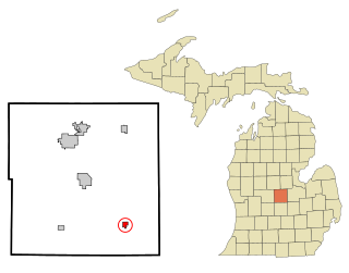
Maple Rapids is a village in Clinton County in the U.S. state of Michigan. The population was 672 at the 2010 census. The village is located in Essex Township about 10 miles (16.1 km) northwest of St. Johns. A portion of the village is within the Maple River State Game Area.

<span class="mw-page-title-main">Ashley, Michigan</span> Village in Michigan, United States

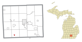
Ashley is a village in Gratiot County in the U.S. state of Michigan. The population was 508 at the 2020 census. The village is located in the northwest corner of Elba Township. No major state trunkline runs through the village, although M-57 passes within one mile to the south. Ashley was platted in 1884.

<span class="mw-page-title-main">Copper City, Michigan</span> Village in Michigan, United States

Copper City is a village in Houghton County of the U.S. state of Michigan. The population was 187 at the 2020 census. The village is within Calumet Township. With an area of 0.08 square miles (0.21 km2), it is the second-smallest incorporated municipality by area in the state of Michigan after the nearby village of Ahmeek.

<span class="mw-page-title-main">Pigeon, Michigan</span> Village in Michigan, United States

Pigeon is a village in Huron County in the U.S. state of Michigan. The population was 1,208 at the 2010 census. The village is within Winsor Township.

<span class="mw-page-title-main">Webberville, Michigan</span> Village in Michigan, United States

Webberville is a village in Ingham County in the U.S. state of Michigan. It is located within Leroy Township. The population was 1,288 at the 2020 census.

<span class="mw-page-title-main">Lyons, Michigan</span> Village in Michigan, United States

Lyons is a village in Ionia County in the U.S. state of Michigan. The population was 789 at the 2010 census. Most of the village is within Lyons Township. A small portion extends west into Ionia Township.

<span class="mw-page-title-main">Hanover, Michigan</span> Village in Michigan, United States

Hanover is a village in Jackson County in the U.S. state of Michigan. The population was 441 at the 2010 census. The village is located within Hanover Township.

<span class="mw-page-title-main">Augusta, Michigan</span> Village in Michigan, United States

Augusta is a village in Kalamazoo County in the U.S. state of Michigan. The population was 885 at the 2010 census. The village is mostly within Ross Township, though a small portion extends south into Charleston Township.

<span class="mw-page-title-main">Custer Township, Mason County, Michigan</span> Civil township in Michigan, United States

Custer Township is a civil township of Mason County in the U.S. state of Michigan. The population was 1,321 at the 2020 census. The village of Custer is located within the township.

<span class="mw-page-title-main">West Monroe, Michigan</span> Census-designated place & unincorporated community in Michigan, United States

West Monroe is an unincorporated community and census-designated place (CDP) in Monroe County in the U.S. state of Michigan. The population was 3,227 at the 2020 census. The CDP is located within Monroe Charter Township.

<span class="mw-page-title-main">St. Charles, Michigan</span> Village in Michigan, United States

St. Charles is a village in Saginaw County in the U.S. state of Michigan. The village is located in the northwest corner of St. Charles Township with portions of the village located within Brant and Swan Creek townships. The population was 2,054 at the 2010 census.

<span class="mw-page-title-main">Anselmo, Nebraska</span> Village in Custer County, Nebraska, United States

Anselmo is a village in Custer County, Nebraska, United States. The population was 145 at the 2010 census.

<span class="mw-page-title-main">Arnold, Nebraska</span> Village in Nebraska, United States

Arnold is a village in Custer County, Nebraska, United States. The population was 597 at the 2010 census. The village was named for George Arnold, a pioneer settler.

<span class="mw-page-title-main">Callaway, Nebraska</span> Village in Nebraska, United States

Callaway is a village in Custer County, Nebraska, United States. The population was 539 at the 2010 census.

<span class="mw-page-title-main">Comstock, Nebraska</span> Village in Custer County, Nebraska, United States

Comstock is a village in Custer County, Nebraska, United States. The population was 93 at the 2010 census.

<span class="mw-page-title-main">Merna, Nebraska</span> Village in Nebraska, United States

Merna is a village in Custer County, Nebraska, United States. The population was 363 at the 2010 census.

<span class="mw-page-title-main">Hubbardston, Michigan</span> Village in Michigan, United States

Hubbardston is a village in the U.S. state of Michigan. It is mostly in North Plains Township in Ionia County, and partially in Lebanon Township in Clinton County. Its population was 395 at the 2010 census.

Lennon is a village in the U.S. state of Michigan. The population was 511 at the 2010 census. The village is located along M-13 within Venice Township in Shiawassee County to the west and Clayton Township in Genesee County to the east.

References

  1. 1 2 "2022 U.S. Gazetteer Files: Michigan". United States Census Bureau. Retrieved August 24, 2023.
  2. 1 2 "P1. Race – Custer village, Michigan: 2020 DEC Redistricting Data (PL 94-171)". U.S. Census Bureau. Retrieved August 24, 2023.
  3. 1 2 "U.S. Census website". United States Census Bureau . Retrieved January 31, 2008.
  4. "US Board on Geographic Names". United States Geological Survey. October 25, 2007. Retrieved January 31, 2008.
  5. Walter Romig, Michigan Place Names, p. 144
  6. Surrarrer, G. Pearl (June 16, 1949). "Place names of county make interesting story". Ludington Daily News . p. 7. Retrieved October 16, 2015.
  7. "Census of Population and Housing". Census.gov. Retrieved June 4, 2015.
  8. "U.S. Census website". United States Census Bureau . Retrieved November 25, 2012.
  9. Climate Summary for Custer, Michigan