Free Soil, Michigan

Last updated

Free Soil, Michigan
Free Soil (village), MI location.png
Location within Mason County
USA Michigan location map.svg
Red pog.svg
Free Soil
Usa edcp location map.svg
Red pog.svg
Free Soil
Coordinates: 44°06′28″N86°12′57″W / 44.10778°N 86.21583°W / 44.10778; -86.21583
Country United States
State Michigan
County Mason
Township Free Soil
Incorporated1912
Area
[1]
  Total1.04 sq mi (2.69 km2)
  Land1.04 sq mi (2.69 km2)
  Water0.00 sq mi (0.00 km2)
Elevation
686 ft (209 m)
Population
 (2020) [2]
  Total158
  Density152.22/sq mi (58.78/km2)
Time zone UTC-5 (Eastern (EST))
  Summer (DST) UTC-4 (EDT)
ZIP Code
49411
Area code 231
FIPS code 26-30600 [3]
GNIS feature ID1617399 [4]

Free Soil is a village in Mason County in the U.S. state of Michigan. The population was 158 at the 2020 census. [2] The village is located within Free Soil Township.

Contents

History

The current village is actually the second settlement in Mason County to be named Free Soil. [5] There are still a few homes in the area now known as "Old Freesoil".

The railroad was extended to Free Soil around 1882, and the village was incorporated in 1912. [6] The community derives its name from the Free Soil Party. [7]

Geography

Free Soil is in northern Mason County, 15 miles (24 km) northeast of Ludington, the county seat (20 miles (32 km) by road), and 13 miles (21 km) southeast of Manistee. According to the United States Census Bureau, the village has a total area of 1.04 square miles (2.69 km2), all land. [1] The village is close to the intersection of Free Soil and Custer Roads, and the Big Sable River runs just north of the village limits.

Demographics

Historical population
CensusPop.Note
1890 306
1920 210
1930 23913.8%
1940 236−1.3%
1950 208−11.9%
1960 2090.5%
1970 186−11.0%
1980 21214.0%
1990 148−30.2%
2000 17719.6%
2010 144−18.6%
2020 1589.7%
U.S. Decennial Census [8]

2010 census

As of the census [9] of 2010, there were 144 people, 64 households, and 41 families residing in the village. The population density was 138.5 inhabitants per square mile (53.5/km2). There were 84 housing units at an average density of 80.8 per square mile (31.2/km2). The racial makeup of the village was 95.8% White, 1.4% African American, and 2.8% Native American.

There were 64 households, of which 23.4% had children under the age of 18 living with them, 46.9% were married couples living together, 15.6% had a female householder with no husband present, 1.6% had a male householder with no wife present, and 35.9% were non-families. 31.3% of all households were made up of individuals, and 12.5% had someone living alone who was 65 years of age or older. The average household size was 2.25 and the average family size was 2.76.

The median age in the village was 44.9 years. 20.8% of residents were under the age of 18; 6.5% were between the ages of 18 and 24; 23.7% were from 25 to 44; 28.5% were from 45 to 64; and 20.8% were 65 years of age or older. The gender makeup of the village was 51.4% male and 48.6% female.

2000 census

As of the census [3] of 2000, there were 177 people, 75 households, and 48 families residing in the village. The population density was 171.2 inhabitants per square mile (66.1/km2). There were 93 housing units at an average density of 90.0 per square mile (34.7/km2). The racial makeup of the village was 93.22% White, 2.26% African American, 0.56% Native American, and 3.95% from two or more races.

There were 75 households, out of which 25.3% had children under the age of 18 living with them, 53.3% were married couples living together, 6.7% had a female householder with no husband present, and 36.0% were non-families. 36.0% of all households were made up of individuals, and 16.0% had someone living alone who was 65 years of age or older. The average household size was 2.36 and the average family size was 3.02.

In the village, the population was spread out, with 22.6% under the age of 18, 9.6% from 18 to 24, 27.7% from 25 to 44, 22.6% from 45 to 64, and 17.5% who were 65 years of age or older. The median age was 40 years. For every 100 females, there were 98.9 males. For every 100 females age 18 and over, there were 98.6 males.

The median income for a household in the village was $27,083, and the median income for a family was $36,000. Males had a median income of $28,750 versus $20,833 for females. The per capita income for the village was $13,329. About 5.6% of families and 9.8% of the population were below the poverty line, including 9.8% of those under the age of eighteen and 11.4% of those 65 or over.

Education

Free Soil previously operated a two-building K-12 school district, with the high school closing in 2007 and elementary closing in 2011. [10] The school had been in operation since 1913. [11]

Related Research Articles

<span class="mw-page-title-main">Mason County, Michigan</span> County in Michigan, United States

Mason County is a county located in the U.S. state of Michigan. As of the 2020 Census, the population was 29,052. The county seat is Ludington.

<span class="mw-page-title-main">Gouldsboro, Maine</span> Town in the state of Maine, United States

Gouldsboro is a town and municipality in Hancock County, Maine, United States on the Schoodic Peninsula. The town was named for Robert Gould, a landholder in the town. The town has many historically separate fishing villages, summer colonies and communities, including Birch Harbor, Prospect Harbor, South Gouldsboro, West Gouldsboro, Summer Harbor, Wonsqueak Harbor, Bunker's Harbor, Chicken Mill, Jones' Pond, Westbay, and Corea. The population was 1,703 at the 2020 census.

<span class="mw-page-title-main">Farwell, Michigan</span> Village in Michigan, United States

Farwell is a village in Clare County in the U.S. state of Michigan. The population was 880 at the 2020 census. The village is located within Surrey Township about 4.0 miles (6.4 km) west of the city of Clare.

<span class="mw-page-title-main">Amber Township, Michigan</span> Civil township in Michigan, United States

Amber Township is a civil township of Mason County in the U.S. state of Michigan. As of the 2020 census, the township population was 2,529.

<span class="mw-page-title-main">Custer, Michigan</span> Village in Michigan, United States

Custer is a village in Mason County in the U.S. state of Michigan. The population was 272 at the 2020 census. The village is located within Custer Township.

<span class="mw-page-title-main">Custer Township, Mason County, Michigan</span> Civil township in Michigan, United States

Custer Township is a civil township of Mason County in the U.S. state of Michigan. The population was 1,321 at the 2020 census. The village of Custer is located within the township.

<span class="mw-page-title-main">Fountain, Michigan</span> Village in Michigan, United States

Fountain is a village in Mason County in the U.S. state of Michigan. The population was 170 at the 2020 census. The village is within Sherman Township.

<span class="mw-page-title-main">Free Soil Township, Michigan</span> Civil township in Michigan, United States

Free Soil Township is a civil township of Mason County in the U.S. state of Michigan. The population was 842 at the 2020 census. The village of Free Soil is located within the township.

<span class="mw-page-title-main">Hamlin Township, Mason County, Michigan</span> Civil township in Michigan, United States

Hamlin Township is a civil township of Mason County in the U.S. state of Michigan. The population was 3,711 at the 2020 census, up from 3,408 in 2010.

<span class="mw-page-title-main">Meade Township, Mason County, Michigan</span> Civil township in Michigan, United States

Meade Township is a civil township of Mason County in the U.S. state of Michigan. The population was 179 at the 2020 census.

<span class="mw-page-title-main">Pere Marquette Charter Township, Michigan</span> Charter township in Michigan, United States

Pere Marquette Charter Township is a charter township of Mason County in the U.S. state of Michigan. The population was 2,416 at the 2020 census.

<span class="mw-page-title-main">Riverton Township, Michigan</span> Civil township in Michigan, United States

Riverton Township is a civil township of Mason County in the U.S. state of Michigan. The population was 1,232 at the 2020 census.

<span class="mw-page-title-main">Scottville, Michigan</span> City in Michigan, United States

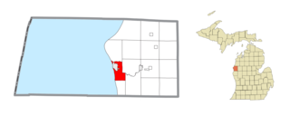
Scottville is a city in Mason County in the U.S. state of Michigan. The population was 1,356 at the 2020 census.

<span class="mw-page-title-main">Sheridan Township, Mason County, Michigan</span> Civil township in Michigan, United States

Sheridan Township is a civil township of Mason County in the U.S. state of Michigan. As of the 2020 census, the township population was 1,044.

<span class="mw-page-title-main">Sherman Township, Mason County, Michigan</span> Civil township in Michigan, United States

Sherman Township is a civil township of Mason County in the U.S. state of Michigan. The population was 1,127 at the 2020 census.

<span class="mw-page-title-main">Summit Township, Mason County, Michigan</span> Civil township in Michigan, United States

Summit Township is a civil township of Mason County in the U.S. state of Michigan. The population was 995 at the 2020 census.

<span class="mw-page-title-main">Wakeman, Ohio</span> Village in Ohio, United States

Wakeman is a village in Huron County, Ohio, United States, along the Vermilion River. Its namesake was Jesup Wakeman, an early settler of Fairfield County, Connecticut, who was involved in western land speculation between 1800 and 1840. The population was 990 at the 2020 census.

<span class="mw-page-title-main">Richfield, Ohio</span> Village in Ohio, United States

Richfield is a village in Summit County, Ohio, United States. The population was 3,729 at the 2020 census. It is located midway between Akron and Cleveland and is part of the Akron metropolitan area.

<span class="mw-page-title-main">Ludington, Wisconsin</span> Town in Wisconsin, United States

Ludington is a town in Eau Claire County, Wisconsin, United States. The population was 1,023 at the 2010 census.

The town of Spring Valley is located in Rock County, in the U.S. state of Wisconsin. The population was 728 at the 2020 census. The only incorporated municipality in the town is the village of Orfordville.

References

  1. 1 2 "2022 U.S. Gazetteer Files: Michigan". United States Census Bureau. Retrieved August 24, 2023.
  2. 1 2 "P1. Race – Free Soil village, Michigan: 2020 DEC Redistricting Data (PL 94-171)". U.S. Census Bureau. Retrieved August 24, 2023.
  3. 1 2 "U.S. Census website". United States Census Bureau . Retrieved January 31, 2008.
  4. "US Board on Geographic Names". United States Geological Survey. October 25, 2007. Retrieved January 31, 2008.
  5. "Freesoil village in national forest". Ludington Daily News. July 11, 1957. p. 5. Retrieved December 2, 2015.
  6. "Free Soil gets history write-up". Ludington Daily News. June 25, 1981. p. 4. Retrieved December 2, 2015.
  7. Moyer, Armond; Moyer, Winifred (1958). The origins of unusual place-names. Keystone Pub. Associates. p. 53.
  8. "Census of Population and Housing". Census.gov. Retrieved June 4, 2015.
  9. "U.S. Census website". United States Census Bureau . Retrieved November 25, 2012.
  10. "Free Soil Says Goodbye to Century Old School". www.9and10news.com. June 21, 2013. Retrieved April 26, 2019.
  11. "Free Soil's first graduating class had one member". www.shorelinemedia.net. Retrieved April 26, 2019.