Grant Township, Mason County, Michigan

Last updated

Grant Township, Michigan
Grant Township (Mason), MI location.png
Location within Mason County
USA Michigan location map.svg
Red pog.svg
Grant Township
Usa edcp location map.svg
Red pog.svg
Grant Township
Coordinates: 44°07′58″N86°21′36″W / 44.13278°N 86.36000°W / 44.13278; -86.36000
Country United States
State Michigan
County Mason
Organized1867
Government
  SupervisorRobert Rakowski
   Clerk Mary Jo Janowiak
Area
[1]
  Total48.92 sq mi (126.7 km2)
  Land48.73 sq mi (126.2 km2)
  Water0.19 sq mi (0.5 km2)
Elevation
663 ft (202 m)
Population
 (2020) [2]
  Total925
  Density19.0/sq mi (7.3/km2)
Time zone UTC-5 (Eastern (EST))
  Summer (DST) UTC-4 (EDT)
ZIP Codes
49411 (Free Soil)
49660 (Manistee)
49431 (Ludington)
Area code 231
FIPS code 26-105-34320 [3]
GNIS feature ID1626382 [4]
Website granttwpmi.org

Grant Township is a civil township of Mason County in the U.S. state of Michigan. As of the 2020 census, the township population was 925. [2]

Contents

The township was named in 1867 for General Ulysses S. Grant, who soon afterward became the 18th president of the United States. [5]

Geography

The township is in northwestern Mason County, bordered to the north by Manistee County and to the west by Lake Michigan. U.S. Route 31 runs north-south along the eastern border of the township. According to the United States Census Bureau, the township has a total area of 48.92 square miles (126.70 km2), of which 48.73 square miles (126.21 km2) are land and 0.19 square miles (0.49 km2), or 0.39%, are water. [1]

The township hall is located on Hoague Road near the intersection of LaSalle Road.

Demographics

As of the census [3] of 2000, there were 850 people, 325 households, and 249 families residing in the township. The population density was 17.5 per square mile (6.7/km2). There were 499 housing units at an average density of 10.3 per square mile (4.0/km2). The racial makeup of the township was 95.29% White, 0.24% African American, 1.41% Native American, 1.29% from other races, and 1.76% from two or more races. Hispanic or Latino of any race were 2.59% of the population.

There were 325 households, out of which 32.9% had children under the age of 18 living with them, 64.6% were married couples living together, 7.1% had a female householder with no husband present, and 23.1% were non-families. 17.2% of all households were made up of individuals, and 8.0% had someone living alone who was 65 years of age or older. The average household size was 2.62 and the average family size was 2.93.

In the township the population was spread out, with 24.5% under the age of 18, 6.7% from 18 to 24, 29.2% from 25 to 44, 27.9% from 45 to 64, and 11.8% who were 65 years of age or older. The median age was 41 years. For every 100 females, there were 107.8 males. For every 100 females age 18 and over, there were 106.4 males.

The median income for a household in the township was $39,018, and the median income for a family was $45,000. Males had a median income of $36,389 versus $21,607 for females. The per capita income for the township was $16,611. About 8.2% of families and 11.4% of the population were below the poverty line, including 11.8% of those under age 18 and 9.8% of those age 65 or over.

Related Research Articles

<span class="mw-page-title-main">Frost Township, Michigan</span> Civil township in Michigan, United States

Frost Township is a civil township of Clare County in the U.S. state of Michigan. The population was 1,038 at the 2020 census.

<span class="mw-page-title-main">Summerfield Township, Clare County, Michigan</span> Civil township in Michigan, United States

Summerfield Township is a civil township of Clare County in the U.S. state of Michigan. The population was 459 at the 2020 census.

<span class="mw-page-title-main">Olive Township, Clinton County, Michigan</span> Civil township in Michigan, United States

Olive Township is a civil township of Clinton County in the U.S. state of Michigan. The population was 2,476 at the 2010 census.

<span class="mw-page-title-main">Waucedah Township, Michigan</span> Civil township in Michigan, United States

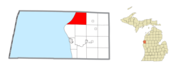
Waucedah Township is a civil township of Dickinson County in the U.S. state of Michigan. The population was 809 at the 2020 census.

<span class="mw-page-title-main">Bliss Township, Michigan</span> Civil township in Michigan, United States

Bliss Township is a civil township of Emmet County in the U.S. state of Michigan. As of the 2010 census, the township population was 620. It was named after Governor Aaron T. Bliss. Bliss Township is the location of Wilderness State Park and White Shoal Light.

<span class="mw-page-title-main">Marenisco Township, Michigan</span> Civil township in Michigan, United States

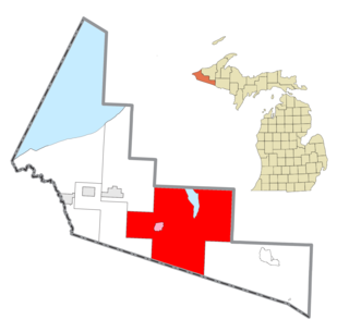
Marenisco Township is a civil township of Gogebic County in the U.S. state of Michigan. The population was 1,727 at the 2010 census, a significant increase from 1,051 at the 2000 census.

<span class="mw-page-title-main">Leroy Township, Ingham County, Michigan</span> Civil township in Michigan, United States

Leroy Township is a civil township of Ingham County in the U.S. state of Michigan. The population was 3,530 at the 2010 census.

<span class="mw-page-title-main">Waterloo Township, Michigan</span> Civil township in Michigan, United States

Waterloo Township is a civil township of Jackson County in the U.S. state of Michigan. The population was 2,856 at the 2010 census.

<span class="mw-page-title-main">Conway Township, Michigan</span> Civil township in Michigan, United States

Conway Township is a civil township of Livingston County in the U.S. state of Michigan. The population was 3,546 at the 2010 census, an increase of 814 from the 2000 census.

Pleasanton Township is a civil township of Manistee County in the U.S. state of Michigan. The population was 870 at the 2020 census.

<span class="mw-page-title-main">Humboldt Township, Michigan</span> Civil township in Michigan, United States

Humboldt Township is a civil township of Marquette County in the U.S. state of Michigan. The population was 413 at the 2020 census, down from 464 in 2010.

<span class="mw-page-title-main">Richmond Township, Marquette County, Michigan</span> Civil township in Michigan, United States

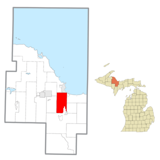
Richmond Township is a civil township of Marquette County in the U.S. state of Michigan. The population was 806 at the 2020 census, down from 882 in 2010. The community of Palmer is located within the township.

<span class="mw-page-title-main">Sands Township, Michigan</span> Civil township in Michigan, United States

Sands Township is a civil township of Marquette County in the U.S. state of Michigan. The population was 2,310 at the 2020 census.

<span class="mw-page-title-main">Milford Township, Michigan</span> Charter township in Michigan, United States

Milford Township is a charter township of Oakland County in the U.S. state of Michigan. The population was 15,736 at the 2010 census. The village of Milford is located within the township.

Center Township is a township in Crow Wing County, Minnesota, United States. The population was 808 at the 2000 census.

Troy Township is a township in Renville County, Minnesota, United States. The population was 325 at the 2000 census.

Leonidas Township is a civil township of St. Joseph County in the U.S. state of Michigan. The population was 1,239 at the 2000 census.

<span class="mw-page-title-main">Brownsville Township, Fayette County, Pennsylvania</span> Township in Pennsylvania, United States

Brownsville Township is a township in Fayette County, Pennsylvania, United States. The population was 534 at the 2020 census, a decline from the figure of 683 tabulated in 2010. It is served by the Brownsville School District.

<span class="mw-page-title-main">Summit Township, Jackson County, Michigan</span> Civil township in Michigan, United States

Summit Township is a civil township of Jackson County in the U.S. state of Michigan. The population was 22,508 at the 2010 census.

<span class="mw-page-title-main">Summerfield Township, Monroe County, Michigan</span> Civil township in Michigan, United States

Summerfield Township is a civil township of Monroe County in the U.S. state of Michigan. The population was 3,308 at the 2010 census.

References

  1. 1 2 "2022 U.S. Gazetteer Files: Michigan". United States Census Bureau. Retrieved September 7, 2023.
  2. 1 2 "P1. Race – Grant township, Michigan: 2020 DEC Redistricting Data (PL 94-171)". U.S. Census Bureau. Retrieved September 7, 2023.
  3. 1 2 "U.S. Census website". United States Census Bureau . Retrieved January 31, 2008.
  4. "US Board on Geographic Names". United States Geological Survey. October 25, 2007. Retrieved January 31, 2008.
  5. "Focus on our history: How county was named". Ludington Daily News. October 3, 1987. p. 2. Retrieved April 30, 2015.