Dakenba, Queensland

Last updated

Dakenba
Queensland
Australia Queensland location map.svg
Red pog.svg
Dakenba
Coordinates 24°20′28″S150°30′18″E / 24.3411°S 150.505°E / -24.3411; 150.505 Coordinates: 24°20′28″S150°30′18″E / 24.3411°S 150.505°E / -24.3411; 150.505
Population116 (2016 census) [1]
 • Density2.193/km2 (5.679/sq mi)
Postcode(s) 4715
Area52.9 km2 (20.4 sq mi)
Time zone AEST (UTC10)
LGA(s) Shire of Banana
State electorate(s) Callide
Federal Division(s) Flynn
Suburbs around Dakenba:
Callide Callide Mount Murchison
Orange Creek Dakenba Mount Murchison
Prospect Biloela Valentine Plains

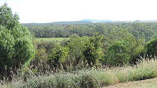
Dakenba is a locality in the Shire of Banana, Queensland, Australia. [2] In the 2016 census, Dakenba had a population of 116 people. [1]

Suburbs and localities are the names of geographic subdivisions in Australia, used mainly for address purposes. The term locality is used in rural areas, while the term suburb is used in urban areas. Australian postcodes closely align with the boundaries of localities and suburbs.

Shire of Banana Local government area in Queensland, Australia

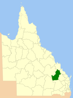
The Shire of Banana is a local government area located in the Capricorn region of Queensland, Australia, inland from the regional city of Gladstone. The shire was named after the first township in the region (Banana), which in turn was named for the burial site of a huge dun coloured bullock named 'Banana'. The council sits in the town of Biloela, which is the largest town in the Shire.

Queensland North-east state of Australia

Queensland is the second-largest and third-most populous state in the Commonwealth of Australia. Situated in the north-east of the country, it is bordered by the Northern Territory, South Australia and New South Wales to the west, south-west and south respectively. To the east, Queensland is bordered by the Coral Sea and Pacific Ocean. To its north is the Torres Strait, with Papua New Guinea located less than 200 km across it from the mainland. The state is the world's sixth-largest sub-national entity, with an area of 1,852,642 square kilometres (715,309 sq mi).

Geography

The Moura railway line passes from the north-west (Callide) to the east (Mount Murchison). [3]

Moura railway line

The Moura railway line is a railway in central Queensland, connecting several coal mines to the port of Gladstone. It connects the remnants of several lines that previously connected to Rockhampton, originally by a rack railway.

Callide, Queensland Town in Queensland, Australia

Callide is a town and a locality in the Shire of Banana, Queensland, Australia.

Mount Murchison, Queensland Suburb of Shire of Banana, Queensland, Australia

Mount Murchison is a locality in the Shire of Banana, Queensland, Australia. In the 2011 census, Mount Murchison had a population of 226 people.

Callide Creek flows from the north-west (Callide) to the south-east (Valentine Plains). [3]

Valentine Plains Suburb of Shire of Banana, Queensland, Australia

Valentine Plains is a locality in the Shire of Banana, Queensland, Australia.

Related Research Articles

Biloela Town in Queensland, Australia

Biloela is a rural town and locality in Shire of Banana, Central Queensland, Australia. It is situated 120 kilometres (75 mi) inland from the port city of Gladstone at the junction of the Burnett and Dawson highways. Biloela is the administrative centre of Banana Shire, which has an area of 15,729 square kilometres (6,073 sq mi). In the 2016 census, Biloela had a population of 5758 people.

Banana, Queensland Town in Queensland, Australia

Banana is a small town and rural locality in the Shire of Banana, Central Queensland, Australia. In the 2011 census, Banana had a population of 377 people.

Baralaba, Queensland Town in Queensland, Australia

Baralaba is a small town and rural locality in the Shire of Banana in central Queensland, Australia. In the 2016 census, Baralaba had a population of 314 people.

Taroom Town in Queensland, Australia

Taroom is a town in the Shire of Banana and locality split between the Shire of Banana and the Western Downs Region in Queensland, Australia. At the 2016 census, Taroom had a population of 869 people.

Cooran, Queensland Town in Queensland, Australia

Cooran is a small hinterland town and locality in the Shire of Noosa in Queensland, Australia. Between 2008 and 2013 it was within Sunshine Coast Region. In the 2011 census, Cooran had a population of 1,457 people.

Cracow, Queensland Town in Queensland, Australia

Cracow is a gold mining town and locality in Queensland, Australia, in the Banana Shire local government area. The town is located on the Theodore – Eidsvold road, 485 kilometres (301 mi) north west of the state capital, Brisbane. At the 2011 census, Cracow and the surrounding area had a population of 196.

Thangool Town in Queensland, Australia

Thangool is a town in central Queensland, Australia. The town is in the Banana Shire local government area, 591 kilometres (367 mi) north west of the state capital, Brisbane and 12 kilometres (7.5 mi) south of the Shire administrative centre, Biloela. The name "Thangool" means "Possum". At the 2011 census, Thangool had a population of 829.

Goovigen Town in Queensland, Australia

Goovigen is a town and a locality in the Shire of Banana, Queensland, Australia.

Jambin, Queensland Town in Queensland, Australia

Jambin is a town and locality in the Shire of Banana, Central Queensland, Australia.

Tingoora Town in Queensland, Australia

Tingoora is a rural town and a locality in the South Burnett Region, Queensland, Australia. In the 2016 census, Tingoora had a population of 273 people.

Minnamoolka, Queensland Suburb of Tablelands Region, Queensland, Australia

Minnamoolka is a locality in the Tablelands Region, Queensland, Australia. In the 2016 census, Minnamoolka had a population of 38 people.

Iron Range, Queensland Suburb of Shire of Cook, Queensland, Australia

Iron Range is a coastal locality in the Shire of Cook, Queensland, Australia. In the 2016 census, Iron Range had a population of 14 people. The town of Portland Road is on a north-east headland in the locality.

Jardine River, Queensland Suburb of Shire of Cook, Queensland, Australia

Jardine River is a coastal locality split between the Shire of Cook and the Shire of Torres in Queensland, Australia. In the 2016 census, Jardine River had a population of 0 people.

Amaroo, Queensland Suburb of Shire of Boulia, Queensland, Australia

Amaroo is an outback locality split between the Shire of Boulia and the Shire of Diamantina, both in Central Western Queensland, Australia. In the 2016 census, Amaroo had a population of 22 people.

Savannah, Queensland Suburb of Shire of Carpentaria, Queensland, Australia

Savannah is a locality in the Shire of Carpentaria, Queensland, Australia. In the 2016 census, Savannah had a population of 0 people.

Finlayvale, Queensland Suburb of Shire of Douglas, Queensland, Australia

Finlayvale is a rural locality in the Shire of Douglas, Queensland, Australia. In the 2016 census, Finlayvale had a population of 32 people.

Farrars Creek, Queensland Suburb of Shire of Barcoo, Queensland, Australia

Farrars Creek is a rural locality in the Shire of Barcoo, Queensland, Australia. In the 2016 census, Farrars Creek had a population of 0 people.

Carrandotta, Queensland Suburb of Shire of Boulia, Queensland, Australia

Carrandotta is a locality in the Shire of Boulia, Queensland, Australia. In the 2016 census, Carrandotta had a population of 0 people.

References

  1. 1 2 Australian Bureau of Statistics (27 June 2017). "Dakenba (SSC)". 2016 Census QuickStats. Retrieved 20 October 2018. OOjs UI icon edit-ltr-progressive.svg
  2. "Dakenba - locality in Shire of Banana (entry 49545)". Queensland Place Names. Queensland Government . Retrieved 24 May 2019.
  3. 1 2 "Queensland Globe". State of Queensland . Retrieved 7 June 2019.