Glebe, Queensland

Last updated

Glebe
Queensland
Machinery Shed at The Glebe (2009).jpg
Machinery Shed at The Glebe Homestead, 2009
Australia Queensland location map.svg
Red pog.svg
Glebe
Coordinates 25°32′18″S150°10′03″E / 25.5383°S 150.1675°E / -25.5383; 150.1675 (Glebe (centre of locality))
Population10 (2021 census) [1]
 • Density0.015/km2 (0.040/sq mi)
Postcode(s) 4419
Area646.2 km2 (249.5 sq mi)
Time zone AEST (UTC+10:00)
Location
LGA(s) Shire of Banana
State electorate(s) Callide
Federal division(s) Flynn
Suburbs around Glebe:
Spring Creek Cracow Cracow
Spring Creek Glebe Cockatoo
Taroom Cockatoo Cockatoo

Glebe is a rural locality in the Shire of Banana, Queensland, Australia. [2] In the 2021 census, Glebe had a population of 10 people. [1]

Contents

Geography

The locality is bounded to the north-west by the Dawson River. [3] The Glebe Weir ( 25°27′53″S150°02′06″E / 25.4646°S 150.0349°E / -25.4646; 150.0349 (Glebe Weir) ) impounds the river to the south-west. [4]

The predominant land use is grazing on native vegetation. There is a small amount of crop growing in the north-west of the locality near the Dawson River with irrigated crops near the weir. [3]

Demographics

In the 2016 census Glebe had a population of 24 people. [5]

In the 2021 census, Glebe had a population of 10 people. [1]

Heritage listings

Glebe has a number of heritage-listed sites, including:

Related Research Articles

<span class="mw-page-title-main">Banana, Queensland</span> Town in Queensland, Australia

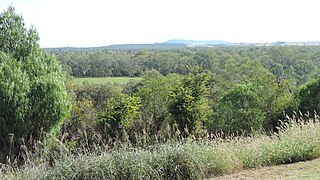
Banana is a rural town and locality in the Shire of Banana, Queensland, Australia. In the 2016 census, the locality of Banana had a population of 356 people.

<span class="mw-page-title-main">Westwood, Queensland</span> Town in Queensland, Australia

Westwood is a town in the Rockhampton Region and a locality split between the Rockhampton Region and the Shire of Banana in Queensland, Australia. It was the first town that was gazetted by the Queensland Government. In the 2021 census, the locality of Westwood had a population of 199 people.

<span class="mw-page-title-main">Theodore, Queensland</span> Town in Queensland, Australia

Theodore is a rural town and locality in the Shire of Banana, Queensland, Australia. It was established in the 1920s as part of Queensland Premier Ted Theodore's ambitious Dawson River Irrigation Scheme which failed to eventuate. It was originally known as Castle Creek, but that name is now used by another locality in the area.

<span class="mw-page-title-main">Baralaba, Queensland</span> Town in Queensland, Australia

Baralaba is a rural town and locality in the Shire of Banana in central Queensland, Australia. In the 2016 census, Baralaba had a population of 314 people.

<span class="mw-page-title-main">Taroom</span> Town in Queensland, Australia

Taroom is a town in the Shire of Banana and locality split between the Shire of Banana and the Western Downs Region in Queensland, Australia. At the 2016 census, Taroom had a population of 869 people.

<span class="mw-page-title-main">Como, Queensland</span> Suburb of Sunshine Coast, Queensland, Australia

Como is a rural locality in the Shire of Noosa, Queensland, Australia. In the 2021 census, Como had a population of 54 people.

<span class="mw-page-title-main">Dululu</span> Town in Queensland, Australia

Dululu is a rural town and locality in the Shire of Banana, Queensland, Australia. In the 2021 census, the locality of Dululu had a population of 97 people.

<span class="mw-page-title-main">Thangool</span> Town in Queensland, Australia

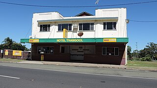
Thangool is a rural town and locality in the Shire of Banana, Queensland, Australia. In the 2016 census, the locality of Thangool had a population of 741 people.

<span class="mw-page-title-main">Jambin, Queensland</span> Town in Queensland, Australia

Jambin is a rural town and locality in the Shire of Banana, Queensland, Australia. In the 2021 census, the locality of Jambin had a population of 207 people.

<span class="mw-page-title-main">Cockatoo, Queensland</span> Suburb of Shire of Banana, Queensland, Australia

Cockatoo is a rural locality in the Shire of Banana, Queensland, Australia. In the 2021 census, Cockatoo had a population of 41 people.

Spring Creek is a rural locality in the Shire of Banana, Queensland, Australia. In the 2016 census Spring Creek had a population of 15 people.

Callide is a rural town and locality in the Shire of Banana, Queensland, Australia. In the 2016 census, the locality of Callide had a population of 86 people.

Greycliffe is a rural locality in the Shire of Banana, Queensland, Australia. In the 2021 census, Greycliffe had a population of 56 people.

Dumpy Creek is a rural locality in the Shire of Banana, Queensland, Australia. In the 2021 census, Dumpy Creek had a population of 16 people.

Dixalea is a rural locality in the Shire of Banana, Queensland, Australia. In the 2021 census, Dixalea had a population of 102 people.

Ulogie is a rural locality in the Shire of Banana, Queensland, Australia. In the 2021 census, Ulogie had a population of 31 people.

Alberta is a rural locality in the Shire of Banana, Queensland, Australia. In the 2021 census, Alberta had a population of 36 people.

Orange Creek is a rural locality in the Shire of Banana, Queensland, Australia. In the 2021 census, Orange Creek had a population of 197 people.

<span class="mw-page-title-main">Kianga, Queensland</span> Suburb of Shire of Banana, Queensland, Australia

Kianga is a rural locality in the Shire of Banana, Queensland, Australia. In the 2021 census, Kianga had a population of 219 people.

Kinnoul is a rural locality in the Shire of Banana, Queensland, Australia. In the 2021 census, Kinnoul had a population of 80 people.

References

  1. 1 2 3 Australian Bureau of Statistics (28 June 2022). "Glebe (SAL)". 2021 Census QuickStats. Retrieved 28 February 2023. OOjs UI icon edit-ltr-progressive.svg
  2. "Glebe – locality in Shire of Banana (entry 49552)". Queensland Place Names. Queensland Government . Retrieved 26 December 2020.
  3. 1 2 "Queensland Globe". State of Queensland . Retrieved 26 December 2020.
  4. "Dawson Valley Weirs & Barrages". Sunwater. Archived from the original on 26 December 2020. Retrieved 26 December 2020.
  5. Australian Bureau of Statistics (27 June 2017). "Glebe (SSC)". 2016 Census QuickStats. Retrieved 20 October 2018. OOjs UI icon edit-ltr-progressive.svg
  6. "The Glebe Homestead (entry 601774)". Queensland Heritage Register . Queensland Heritage Council. Retrieved 6 July 2013.

Commons-logo.svg Media related to Glebe, Queensland at Wikimedia Commons