Kianga, Queensland

Last updated

Kianga
Queensland
Coal train, Moura mine, c 1966.jpg
Coal train, Moura mine, circa 1966
Australia Queensland location map.svg
Red pog.svg
Kianga
Coordinates 24°41′25″S150°01′35″E / 24.6902°S 150.0263°E / -24.6902; 150.0263 (Kianga (centre of locality))
Population219 (2021 census) [1]
 • Density0.5281/km2 (1.368/sq mi)
Postcode(s) 4718
Elevation100–280 m (328–919 ft) [2]
Area414.7 km2 (160.1 sq mi)
Time zone AEST (UTC+10:00)
Location
LGA(s) Shire of Banana
State electorate(s) Callide
Federal division(s) Flynn
Suburbs around Kianga:
Moura Moura Banana
Warnoah Kianga Banana
Warnoah Glenmoral Lonesome Creek

Kianga is a rural locality in the Shire of Banana, Queensland, Australia. [3] In the 2021 census, Kianga had a population of 219 people. [1]

Contents

Geography

The land use is a mixture of mining, grazing on native vegetation, and crop growing. [2]

There are a number of railway stations within the locality:

History

The locality takes its name from the former railway station, named on 23 December 1937 by Queensland Railways Department after a pastoral run. It is an Aboriginal word, meaning home. [3]

On 20 September 1975, there was an explosion in Kianga No. 1 underground coal mine resulting in the deaths of 13 miners. [5] On 11 March 1978, a memorial centre in Moura (the nearest town) was officially opened to commemorate the disaster. [6]

Demographics

In the 2016 census, Kianga had a population of 227 people. [7]

In the 2021 census, Kianga had a population of 219 people. [1]

Education

There are no schools in Kianga. The nearest government primary schools are Moura State School in neighbouring Moura to the north-west, Banana State School in neighbouring Banana to the north-east, and Theodore State School in Theodore to the south. The nearest government secondary schools are Moura State High School (to Year 12) in Moura and Theodore State School (to Year 10) in Theodore. [8]

Related Research Articles

<span class="mw-page-title-main">Dululu</span> Town in Queensland, Australia

Dululu is a rural town and locality in the Shire of Banana, Queensland, Australia. In the 2021 census, the locality of Dululu had a population of 97 people.

<span class="mw-page-title-main">Thangool</span> Town in Queensland, Australia

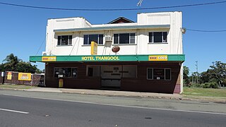
Thangool is a rural town and locality in the Shire of Banana, Queensland, Australia. In the 2016 census, the locality of Thangool had a population of 741 people.

<span class="mw-page-title-main">Goovigen</span> Town in Queensland, Australia

Goovigen is a rural town and locality in the Shire of Banana, Queensland, Australia. In the 2016 census, the locality of Goovigen had a population of 215 people.

<span class="mw-page-title-main">Wowan, Queensland</span> Town in Queensland, Australia

Wowan is a rural town and locality in the Shire of Banana, Queensland, Australia. In the 2016 census, the locality of Wowan had a population of 216 people.

<span class="mw-page-title-main">Jambin, Queensland</span> Town in Queensland, Australia

Jambin is a rural town and locality in the Shire of Banana, Queensland, Australia. In the 2021 census, the locality of Jambin had a population of 207 people.

<span class="mw-page-title-main">Karara, Queensland</span> Town in Queensland, Australia

Karara is a rural town and locality in the Southern Downs Region, Queensland, Australia. In the 2016 census, the locality of Karara had a population of 123 people.

<span class="mw-page-title-main">Dawson Valley (Theodore) railway line</span> Former railway line in Queensland, Australia

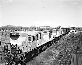
The Dawson Valley Branch Railway was a railway line in Central Queensland, Australia. It branched from the Central Western railway line at Kabra in the Rockhampton Region and went via Mount Morgan to Theodore in the Shire of Banana. It opened in a series of sections between 1898 and 1927, and featured a rack railway section, one of only 3 such systems in Australia.

<span class="mw-page-title-main">Baree, Queensland</span> Suburb of Rockhampton Region, Queensland, Australia

Baree is a rural locality in the Rockhampton Region, Queensland, Australia. In the 2021 census, Baree had a population of 201 people.

Camboon is a rural locality in the Shire of Banana, Queensland, Australia. In the 2021 census, Camboon had a population of 76 people.

<span class="mw-page-title-main">Gogango</span> Town in Queensland, Australia

Gogango is a rural town and locality in the Rockhampton Region, Queensland, Australia. In the 2016 census the locality of Gogango had a population of 111 people.

Bakers Bend is a rural locality in the Shire of Murweh, Queensland, Australia. In the 2021 census, Bakers Bend had a population of 7 people.

Kumbarilla is a town and rural locality in the Western Downs Region, Queensland, Australia. In the 2016 census, the locality of Kumbarilla had a population of 197 people.

Kurumbul is a rural town and locality in the Goondiwindi Region, Queensland, Australia. It is on the border of Queensland and New South Wales. In the 2016 census, Kurumbul had a population of 46 people.

Rywung is a locality in the Western Downs Region, Queensland, Australia.

Callide is a rural town and locality in the Shire of Banana, Queensland, Australia. In the 2016 census, the locality of Callide had a population of 86 people.

<span class="mw-page-title-main">Lawgi Dawes</span> Suburb of Shire of Banana, Queensland, Australia

Lawgi Dawes is a rural locality in the Shire of Banana, Queensland, Australia. It contains the neighbourhood of Lawgi, a former town.

Dakenba is a rural locality in the Shire of Banana, Queensland, Australia. In the 2021 census, Dakenba had a population of 127 people.

Orange Creek is a rural locality in the Shire of Banana, Queensland, Australia. In the 2021 census, Orange Creek had a population of 197 people.

<span class="mw-page-title-main">Mount Alma, Queensland</span> Suburb of Gladstone Region, Queensland, Australia

Mount Alma is a rural locality in the Gladstone Region, Queensland, Australia. In the 2016 census, Mount Alma had a population of 47 people.

Wura is a rural locality in the Rockhampton Region, Queensland, Australia. In the 2021 census, Wura had a population of 17 people.

References

  1. 1 2 3 Australian Bureau of Statistics (28 June 2022). "Kianga (SAL)". 2021 Census QuickStats. Retrieved 28 February 2023. OOjs UI icon edit-ltr-progressive.svg
  2. 1 2 "Queensland Globe". State of Queensland . Retrieved 1 October 2023.
  3. 1 2 "Kianga – locality in Shire of Banana (entry 49559)". Queensland Place Names. Queensland Government . Retrieved 25 October 2019.
  4. 1 2 3 4 5 6 7 "Railway stations and sidings - Queensland". Queensland Open Data. Queensland Government. 2 October 2020. Archived from the original on 5 October 2020. Retrieved 5 October 2020.
  5. "Kianga No. 1 Mine Explosion 1975". Mining Accident Database. Archived from the original on 23 March 2023. Retrieved 2 October 2023.
  6. "Kianga Memorial Centre". Monument Australia. Archived from the original on 2 October 2023. Retrieved 2 October 2023.
  7. Australian Bureau of Statistics (27 June 2017). "Kianga (SSC)". 2016 Census QuickStats. Retrieved 20 October 2018. OOjs UI icon edit-ltr-progressive.svg
  8. "Layers: Locality; Schools and school catchments". Queensland Globe. Queensland Government. Archived from the original on 19 December 2017. Retrieved 1 October 2023.