
Banana is a rural town and locality in the Shire of Banana, Queensland, Australia. In the 2021 census, the locality of Banana had a population of 348 people.

Westwood is a town in the Rockhampton Region and a locality split between the Rockhampton Region and the Shire of Banana in Queensland, Australia. It was the first town that was gazetted by the Queensland Government. In the 2021 census, the locality of Westwood had a population of 199 people.

Dululu is a rural town and locality in the Shire of Banana, Queensland, Australia. In the 2021 census, the locality of Dululu had a population of 97 people.

Cracow is a rural town and locality in the Shire of Banana, Queensland, Australia. Historically, Cracow is a gold mining town, with some recent mines opening. In the 2021 census, the locality of Cracow had a population of 114 people.
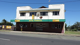
Thangool is a rural town and locality in the Shire of Banana, Queensland, Australia. In the 2021 census, the locality of Thangool had a population of 685 people.

Goovigen is a rural town and locality in the Shire of Banana, Queensland, Australia. In the 2021 census, the locality of Goovigen had a population of 349 people.

Wowan is a rural town and locality in the Shire of Banana, Queensland, Australia. In the 2021 census, the locality of Wowan had a population of 170 people.

Jambin is a rural town and locality in the Shire of Banana, Queensland, Australia. In the 2021 census, the locality of Jambin had a population of 207 people.
McIlwraith is a rural locality in the Bundaberg Region, Queensland, Australia. In the 2021 census, McIlwraith had a population of 202 people.

Cockatoo is a rural locality in the Shire of Banana, Queensland, Australia. In the 2021 census, Cockatoo had a population of 41 people.
Prospect is a rural locality in the Shire of Banana, Queensland, Australia. In the 2021 census, Prospect had a population of 289 people.
Spring Creek is a rural locality in the Shire of Banana, Queensland, Australia. In the 2021 census, Spring Creek had a population of 20 people.

Callide is a rural town and locality in the Shire of Banana, Queensland, Australia. In the 2021 census, the locality of Callide had a population of 80 people.
Greycliffe is a rural locality in the Shire of Banana, Queensland, Australia. In the 2021 census, Greycliffe had a population of 56 people.
Pheasant Creek is a rural locality in the Shire of Banana, Queensland, Australia. In the 2021 census, Pheasant Creek had a population of 48 people.
Dakenba is a rural locality in the Shire of Banana, Queensland, Australia. In the 2021 census, Dakenba had a population of 127 people.
Orange Creek is a rural locality in the Shire of Banana, Queensland, Australia. In the 2021 census, Orange Creek had a population of 197 people.

Lonesome Creek is a rural locality in the Shire of Banana, Queensland, Australia. In the 2021 census, Lonesome Creek had a population of 173 people.
Castle Creek is a rural locality in the Shire of Banana, Queensland, Australia. In the 2021 census, Castle Creek had a population of 57 people.
Lake Mary is a rural locality in the Livingstone Shire, Queensland, Australia. In the 2021 census, Lake Mary had a population of 96 people.
