Kinnoul, Queensland

Last updated

Kinnoul
Queensland
Australia Queensland location map.svg
Red pog.svg
Kinnoul
Coordinates 25°39′45″S149°32′17″E / 25.6625°S 149.5380°E / -25.6625; 149.5380 (Kinnoul (centre of locality))
Population80 (2021 census) [1]
 • Density0.098/km2 (0.255/sq mi)
Postcode(s) 4420
Area813.0 km2 (313.9 sq mi)
Time zone AEST (UTC+10:00)
Location
  • 39.4 km (24 mi) SW of Taroom
  • 136 km (85 mi) NE of Roma
  • 236 km (147 mi) SW of Biloela
  • 475 km (295 mi) NW of Brisbane
LGA(s) Shire of Banana
State electorate(s) Callide
Federal division(s) Flynn
Suburbs around Kinnoul:
Broadmere Broadmere Taroom
Baroondah Kinnoul Taroom
Eurombah Eurombah Taroom

Kinnoul is a rural locality in the Shire of Banana, Queensland, Australia. [2] In the 2021 census, Kinnoul had a population of 80 people. [1]

Contents

Geography

The locality is bounded to the south in parts by the Dawson River. The western edge of the locality is mountainous with elevations up to 380 metres (1,250 ft) above sea level, falling to 190 metres (620 ft) towards the south and east of the locality. An exception to this is Mount Kinnoul in the south-east of the locality ( 25°40′04″S149°40′09″E / 25.6677°S 149.6691°E / -25.6677; 149.6691 (Mount Kinnoul) ) which rises to 378 metres (1,240 ft). [3] [4] [5] [6]

Lynd Range ( 25°34′34″S149°23′43″E / 25.5760°S 149.3952°E / -25.5760; 149.3952 (Lynd Range) ) extends from neighbouring Broadmere to the north into Kinnoul. [7]

The land use is predominantly grazing on native vegetation with some crop growing. [4]

History

In the garden at Kinnoull Station, Dawson River, Queensland, 1864 StateLibQld 1 70579 In the garden at Kinnoull Station, Dawson River, Queensland, 1864.jpg
In the garden at Kinnoull Station, Dawson River, Queensland, 1864

The locality was officially named and bounded on 20 May 2005. [2] However, the name has been in use since at least 1862 where it was part of a mail route from Taroom to Bungeworgorai. [8] It probably takes its name from the Kinnoul pastoral lease taken out by Robert Miller and John Turnbull in 1851. [9]

Demographics

In the 2016 census Kinnoul had a population of 69 people. [10]

In the 2021 census, Kinnoul had a population of 80 people. [1]

Economy

There are a number of homesteads in the locality: [11]

Transport

Cowangah pastoral run has an airstrip ( 25°44′05″S149°28′16″E / 25.7348°S 149.4712°E / -25.7348; 149.4712 (Cowangah airstrip) ). [12]

Yurnga pastoral run has an airstrip ( 25°39′31″S149°22′31″E / 25.6587°S 149.3753°E / -25.6587; 149.3753 (Yurnga airstrip) ). [12]

Education

There are no schools in Kinnoul. The nearest school is Taroom State School in neighbouring Taroom to the east; it provides primary schooling and secondary schooling to Year 10. There are no nearby schools providing secondary schooling to Year 12. [4] Distance education or boarding schools are options.

Related Research Articles

<span class="mw-page-title-main">Hebel, Queensland</span> Town in Queensland, Australia

Hebel is a rural town and locality in the Shire of Balonne, Queensland, Australia. It is on the border of Queensland and New South Wales. In the 2016 census, Hebel had a population of 67 people.

<span class="mw-page-title-main">Taroom</span> Town in Queensland, Australia

Taroom is a town in the Shire of Banana and locality split between the Shire of Banana and the Western Downs Region in Queensland, Australia. At the 2016 census, Taroom had a population of 869 people.

<span class="mw-page-title-main">Shire of Taroom</span> Local government area in Queensland, Australia

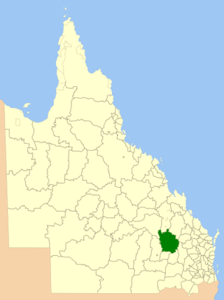
The Shire of Taroom was a local government area in the Darling Downs region of Queensland, Australia, along the Leichhardt Highway to the north of Miles. The shire covered an area of 18,644.5 square kilometres (7,198.7 sq mi), and existed as a local government area from 1879 until 2008, when it was dissolved and split between the new Western Downs Region and the Shire of Banana.

<span class="mw-page-title-main">Goovigen</span> Town in Queensland, Australia

Goovigen is a rural town and locality in the Shire of Banana, Queensland, Australia. In the 2016 census, the locality of Goovigen had a population of 215 people.

Gilbert River is a rural locality in the Shire of Etheridge, Queensland, Australia. In the 2021 census, Gilbert River had a population of 32 people.

<span class="mw-page-title-main">Gogango</span> Town in Queensland, Australia

Gogango is a rural town and locality in the Rockhampton Region, Queensland, Australia. In the 2016 census the locality of Gogango had a population of 111 people.

<span class="mw-page-title-main">Glebe, Queensland</span> Suburb of Shire of Banana, Queensland, Australia

Glebe is a rural locality in the Shire of Banana, Queensland, Australia. In the 2021 census, Glebe had a population of 10 people.

<span class="mw-page-title-main">Eurombah, Queensland</span> Suburb of Shire of Banana, Queensland, Australia

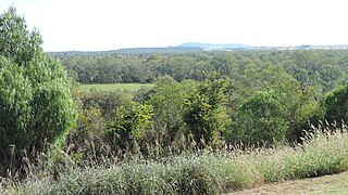
Eurombah is a rural locality split between the Shire of Banana and the Western Downs Region, Queensland, Australia. In the 2021 census, Eurombah had a population of 100 people.

<span class="mw-page-title-main">Tanbar, Queensland</span> Suburb of Shire of Barcoo, Queensland, Australia

Tanbar is an outback locality in the Shire of Barcoo, Queensland, Australia. It is on the corner of Queensland's southern and western border with South Australia. In the 2016 census Tanbar had a population of 3 people.

Kioma is a rural locality in the Goondiwindi Region, Queensland, Australia. In the 2021 census, Kioma had a population of 32 people.

North Bungunya is a rural locality in the Goondiwindi Region, Queensland, Australia. In the 2016 census North Bungunya had a population of 39 people.

Linden is a rural locality in the Shire of Paroo, Queensland, Australia. In the 2021 census, Linden had a population of 5 people.

Spring Creek is a rural locality in the Shire of Banana, Queensland, Australia. In the 2016 census Spring Creek had a population of 15 people.

Strathmore is a locality split between the Shire of Mareeba and the Shire of Etheridge, in Queensland, Australia. In the 2016 census Strathmore had a population of 12 people.

<span class="mw-page-title-main">Lyndhurst, Queensland</span> Suburb of Shire of Etheridge, Queensland, Australia

Lyndhurst is a rural locality in the Shire of Etheridge, Queensland, Australia. In the 2021 census, Lyndhurst had a population of 11 people.

<span class="mw-page-title-main">Talaroo, Queensland</span> Suburb of Shire of Etheridge, Queensland, Australia

Talaroo is an outback locality in the Shire of Etheridge, Queensland, Australia. In the 2021 census, Talaroo had a population of 5 people.

Alberta is a rural locality in the Shire of Banana, Queensland, Australia. In the 2021 census, Alberta had a population of 36 people.

Humboldt is a rural locality in the Central Highlands Region, Queensland, Australia. In the 2021 census, Humboldt had a population of 49 people.

Kunwarara is a rural locality in the Livingstone Shire, Queensland, Australia. In the 2021 census, Kunwarara had a population of 69 people.

<span class="mw-page-title-main">Taldora, Queensland</span> Suburb of Shire of Mckinlay, Queensland, Australia

Taldora is an outback locality in the Shire of Mckinlay, Queensland, Australia. In the 2016 census Taldora had a population of 37 people.

References

  1. 1 2 3 Australian Bureau of Statistics (28 June 2022). "Kinnoul (SAL)". 2021 Census QuickStats. Retrieved 28 February 2023. OOjs UI icon edit-ltr-progressive.svg
  2. 1 2 "Kinnoul – locality in Shire of Banana (entry 49561)". Queensland Place Names. Queensland Government . Retrieved 14 December 2020.
  3. "Mount Kinnoul – mountain in Shire of Banana (entry 18263)". Queensland Place Names. Queensland Government . Retrieved 14 December 2020.
  4. 1 2 3 "Queensland Globe". State of Queensland . Retrieved 14 December 2020.
  5. "Mountain peaks and capes - Queensland". Queensland Open Data. Queensland Government. 12 November 2020. Archived from the original on 25 November 2020. Retrieved 25 November 2020.
  6. "Mount Kinnoul – mountain in Banana Shire (entry 18263)". Queensland Place Names. Queensland Government . Retrieved 25 November 2020.
  7. "Mountain ranges beaches and sea passages - Queensland". Queensland Open Data. Queensland Government. 12 November 2020. Archived from the original on 25 November 2020. Retrieved 25 November 2020.
  8. "General Post Office, Brisbane, 31st July, 1862. Conveyance of Mails". North Australian And Queensland General Advertiser . Vol. VIII, no. 496. Queensland, Australia. 9 August 1862. p. 3. Retrieved 14 December 2020 via National Library of Australia.
  9. "Glebe Weir Raising and Pipeline Impact Assessment: Chapter 16: Cultural Heritage" (PDF). Queensland Government. p. 13.
  10. Australian Bureau of Statistics (27 June 2017). "Kinnoul (SSC)". 2016 Census QuickStats. Retrieved 20 October 2018. OOjs UI icon edit-ltr-progressive.svg
  11. "Homesteads - Queensland". Queensland Open Data. Queensland Government. 18 November 2020. Archived from the original on 24 November 2020. Retrieved 24 November 2020.
  12. 1 2 "Heliports and landing grounds - Queensland". Queensland Open Data. Queensland Government. 22 October 2020. Archived from the original on 16 November 2020. Retrieved 3 November 2020.