Dakota, Illinois

Last updated

Dakota
Stephenson County Illinois Incorporated and Unincorporated areas Dakota Highlighted.svg
Location of Dakota in Stephenson County, Illinois.
Illinois in United States (US48).svg
Location of Illinois in the United States
Coordinates: 42°23′17″N89°31′27″W / 42.38806°N 89.52417°W / 42.38806; -89.52417
CountryUnited States
StateIllinois
County Stephenson
Township Dakota
IncorporatedMarch 11, 1869 (1869-03-11)
Government
  MayorAlisha Lizer
Area
[1]
  Total0.25 sq mi (0.64 km2)
  Land0.25 sq mi (0.64 km2)
  Water0.00 sq mi (0.00 km2)
Elevation
945 ft (288 m)
Population
 (2020)
  Total500
  Density2,008.03/sq mi (776.71/km2)
ZIP Code(s)
61018
Area code 815
FIPS code 17-18342
[2]

Dakota is an village in Stephenson County, Illinois, United States. The population was 506 at the 2010 census, up from 499 in 2000.

Contents

History

Dakota was laid out in 1857 when the railroad was extended to that point. [3] A post office has been in operation at Dakota since 1857. [4]

Geography

Dakota is located at 42°23′17″N89°31′27″W / 42.38806°N 89.52417°W / 42.38806; -89.52417 (42.387936, -89.524289). [5]

According to the 2010 census, Dakota has a total area of 0.29 square miles (0.75 km2), all land. [6]

Demographics

Historical population
CensusPop.Note
1880 257
1890 28310.1%
1900 269−4.9%
1910 227−15.6%
1920 2489.3%
1930 2490.4%
1940 2687.6%
1950 31818.7%
1960 36314.2%
1970 44021.2%
1980 57129.8%
1990 549−3.9%
2000 499−9.1%
2010 5061.4%
2020 500−1.2%
U.S. Decennial Census [7]

As of the census [8] of 2000, there were 499 people, 197 households, and 141 families residing in the town. The population density was 1,731.9 inhabitants per square mile (668.7/km2). There were 203 housing units at an average density of 704.6 per square mile (272.0/km2). The racial makeup of the town was 98.00% White, 0.80% African American, 0.40% Native American, 0.40% Asian, 0.40% from other races. Hispanic or Latino of any race were 0.40% of the population.

There were 197 households, out of which 32.0% had children under the age of 18 living with them, 58.9% were married couples living together, 11.2% had a female householder with no husband present, and 28.4% were non-families. 27.4% of all households were made up of individuals, and 11.7% had someone living alone who was 65 years of age or older. The average household size was 2.53 and the average family size was 3.03.

In the town, the population was spread out, with 24.6% under the age of 18, 9.2% from 18 to 24, 30.1% from 25 to 44, 22.2% from 45 to 64, and 13.8% who were 65 years of age or older. The median age was 38 years. For every 100 females, there were 96.5 males. For every 100 females age 18 and over, there were 92.8 males.

The median income for a household in the town was $43,942, and the median income for a family was $50,357. Males had a median income of $35,263 versus $25,000 for females. The per capita income for the town was $18,440. About 1.4% of families and 3.9% of the population were below the poverty line, including 3.6% of those under age 18 and 8.8% of those age 65 or over.

Related Research Articles

<span class="mw-page-title-main">Stephenson County, Illinois</span> County in Illinois, United States

Stephenson County is a county located in the U.S. state of Illinois. According to the 2020 United States Census, it had a population of 44,630. Its county seat is Freeport.

<span class="mw-page-title-main">Girard, Illinois</span> City in Illinois, United States

Girard is a city in Macoupin County, Illinois, United States. The population was 1,785 at the 2020 census, down from 2,103 in 2010.

<span class="mw-page-title-main">Cedarville, Illinois</span> Village in Illinois, United States

Cedarville is a village in Stephenson County, Illinois, United States. The population was 741 at the 2010 census, up from 719 in 2000. It is the birthplace of social activist Jane Addams, the 1931 Nobel Peace Prize winner.

<span class="mw-page-title-main">Davis, Illinois</span> Village in Illinois, United States

Davis is a village in Stephenson County, Illinois, United States. The population was 677 at the 2010 census, up from 662 in 2000.

<span class="mw-page-title-main">German Valley, Illinois</span> Village in Illinois, United States

German Valley is a village in Stephenson County, Illinois, United States. German Valley is located four miles south of U.S. Route 20 between Freeport and Rockford. German Valley had a population of 433 at the 2020 census, with a 2023 estimate of 424.

<span class="mw-page-title-main">Lake Summerset, Illinois</span> Census Designated Place in Illinois, United States

Lake Summerset is a census-designated place (CDP) in Stephenson and Winnebago counties in Illinois. The population was 2,048 at the 2010 census.

<span class="mw-page-title-main">Pearl City, Illinois</span> Village in Illinois, United States

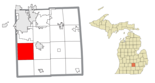
Pearl City is an incorporated village in Stephenson County, Illinois, with a population of 838 at the 2010 census, up from 780 in 2000.

<span class="mw-page-title-main">Ridott, Illinois</span> Village in Illinois, United States

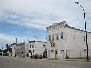
Ridott is a village in Stephenson County, Illinois, United States. As of the 2010 census, the village population was 164, up from 158 in 2000.

<span class="mw-page-title-main">Rock City, Illinois</span> Village in Illinois, United States

Rock City is a village in Stephenson County, Illinois. The population was 315 at the 2010 census, up from 313 in 2000.

<span class="mw-page-title-main">Winslow, Illinois</span> Village in Illinois, United States

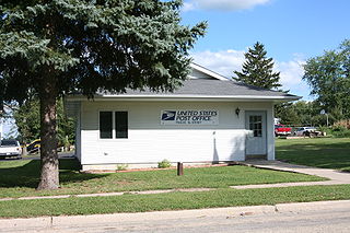
Winslow is a village in Stephenson County, Illinois. The population was 338 at the 2010 census, down from 345 in 2000.

<span class="mw-page-title-main">Aurelius Township, Michigan</span> Civil township in Michigan, United States

Aurelius Township is a civil township of Ingham County in the U.S. state of Michigan. As of the 2020 census, the township population was 4,354, a significant increase from 3,525 at the 2010 census.

<span class="mw-page-title-main">Esmond, North Dakota</span> City in North Dakota, United States

Esmond is a city in Benson County, North Dakota, United States. The population was 91 at the 2020 census. Esmond was founded in 1901.

<span class="mw-page-title-main">Sandy Lake Township, Pennsylvania</span> Township in Pennsylvania, United States

Sandy Lake Township is a township that is located in Mercer County, Pennsylvania, United States. The population was 1,197 at the time of the 2020 census, a decline from the figure of 1,226 that was documented in 2010.

<span class="mw-page-title-main">Wagner, South Dakota</span> City in South Dakota, United States

Wagner is a city in Charles Mix County, South Dakota, United States. The population was 1,490 at the 2020 census. The city is served by Wagner Municipal Airport as well as YST Transit buses.

<span class="mw-page-title-main">Isabel, South Dakota</span> Town in South Dakota, United States

Isabel is a town in Dewey County, South Dakota, United States. The population was 145 at the 2020 census.

<span class="mw-page-title-main">Gregory, South Dakota</span> City in South Dakota, United States

Gregory is a city in western Gregory County, South Dakota, United States. The population was 1,221 at the 2020 census.

<span class="mw-page-title-main">Hazel, South Dakota</span> Town in South Dakota, United States

Hazel is a town in Hamlin County, South Dakota, United States. It is part of the Watertown, South Dakota Micropolitan Statistical Area. The population was 102 at the 2020 census.

<span class="mw-page-title-main">Leola, South Dakota</span> City in South Dakota, United States

Leola is a small city in, and the county seat of, McPherson County, South Dakota, United States. It was founded on May 1, 1884, and named for Leola Haynes, daughter of one of the town's founders. The population was 434 as of the 2020 census.

<span class="mw-page-title-main">Corona, South Dakota</span> Town in South Dakota, United States

Corona is a town in Roberts County, South Dakota, United States. The population was 69 at the 2020 census.

<span class="mw-page-title-main">Duxbury (CDP), Massachusetts</span> Census-designated place in Massachusetts, United States

Duxbury is a census-designated place (CDP) in the town of Duxbury in Plymouth County, Massachusetts, United States. The population was 1,802 at the 2010 census.

References

  1. "2020 U.S. Gazetteer Files". United States Census Bureau. Retrieved March 15, 2022.
  2. Illinois Regional Archives Depository System. "Name Index to Illinois Local Governments". Illinois State Archives. Illinois Secretary of State . Retrieved April 26, 2013.
  3. Callary, Edward (September 29, 2008). Place Names of Illinois. University of Illinois Press. p. 85. ISBN   978-0-252-09070-7.
  4. "Stephenson County". Jim Forte Postal History. Archived from the original on January 31, 2016. Retrieved November 3, 2015.
  5. "US Gazetteer files: 2010, 2000, and 1990". United States Census Bureau. February 12, 2011. Retrieved April 23, 2011.
  6. "G001 - Geographic Identifiers - 2010 Census Summary File 1". United States Census Bureau. Archived from the original on February 13, 2020. Retrieved August 1, 2015.
  7. "Census of Population and Housing". Census.gov. Retrieved June 4, 2015.
  8. "U.S. Census website". United States Census Bureau . Retrieved January 31, 2008.