Danville, Georgia

Last updated

Danville, Georgia
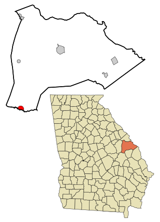
Twiggs County Georgia Incorporated and Unincorporated areas Danville Highlighted.svg
Location in Twiggs County and the state of Georgia
Coordinates: 32°36′20″N83°14′41″W / 32.60556°N 83.24472°W / 32.60556; -83.24472
Country United States
State Georgia
Counties Twiggs, Wilkinson
Area
[1]
  Total0.79 sq mi (2.04 km2)
  Land0.79 sq mi (2.04 km2)
  Water0.00 sq mi (0.00 km2)
Elevation
449 ft (137 m)
Population
 (2020)
  Total165
  Density209.13/sq mi (80.74/km2)
Time zone UTC-5 (Eastern (EST))
  Summer (DST) UTC-4 (EDT)
ZIP code
31017
Area code 478
FIPS code 13-21688 [2]
GNIS feature ID0355443 [3]
Website cityofdanvillega.com

Danville is a town in Twiggs and Wilkinson counties in the U.S. state of Georgia. The population was 238 at the 2010 census, down from 373 in 2000.

Contents

The Twiggs County portion of Danville is part of the Macon metropolitan statistical area.

History

Danville was originally called "Hughes", and under that name had its start about 1891 when the railroad was extended to that point. [4] The Georgia General Assembly incorporated the place in 1905 as the "Town of Danville". [5] The town was named for Daniel G. Hughes, father of U.S. Representative Dudley Mays Hughes. [6]

Geography

Danville is located at 32°36′20″N83°14′41″W / 32.60556°N 83.24472°W / 32.60556; -83.24472 (32.605607, -83.244762). [7]

Interstate 16 runs northwest to southeast just south of town, leading southeast 137 mi (220 km) to Savannah and northwest 31 mi (50 km) to Macon. The town is also traversed by U.S. Route 80 and Georgia State Route 358.

According to the United States Census Bureau, the town has a total area of 0.8 square miles (2.1 km2), all land.

Demographics

Historical population
CensusPop.Note
1910 299
1920 43645.8%
1930 419−3.9%
1940 4231.0%
1950 4619.0%
1960 264−42.7%
1970 51595.1%
1980 5292.7%
1990 480−9.3%
2000 373−22.3%
2010 238−36.2%
2020 165−30.7%
U.S. Decennial Census [8]
1850-1870 [9] 1870-1880 [10]
1890-1910 [11] 1920-1930 [12]
1940 [13] 1950 [14] 1960 [15]
1970 [16] 1980 [17] 1990 [18]
2000 [19] 2010 [20] 2020 [21]
Danville town, Georgia – Racial and ethnic composition
(NH = Non-Hispanic)
Note: the US Census treats Hispanic/Latino as an ethnic category. This table excludes Latinos from the racial categories and assigns them to a separate category. Hispanics/Latinos may be of any race.
Race / EthnicityPop 2010 [20] Pop 2020 [21] % 2010% 2020
White alone (NH)1398758.40%52.73%
Black or African American alone (NH)936739.08%40.61%
Native American or Alaska Native alone (NH)000.00%0.00%
Asian alone (NH)000.00%0.00%
Pacific Islander alone (NH)000.00%0.00%
Other race alone (NH)000.00%0.00%
Mixed race or Multiracial (NH)070.00%4.24%
Hispanic or Latino (any race)642.52%2.42%
Total238165100.00%100.00%

Related Research Articles

<span class="mw-page-title-main">Peach County, Georgia</span> County in Georgia, United States

Peach County is a county located in the central portion of the U.S. state of Georgia. As of the 2020 census, the population was 27,981. Its county seat is Fort Valley. Founded in 1924, it is the state's newest county, taken from Houston and Macon counties on July 18 of that year. Its namesake is the peach on account of it being located in a peach-growing district.
<span class="mw-page-title-main">Midville, Georgia</span> City in Georgia, United States

Midville is a city in Burke County, Georgia, United States. The population was 269 at the 2010 census, and 385 in 2020. It is part of the Augusta, Georgia metropolitan area.

<span class="mw-page-title-main">Dooling, Georgia</span> Town in Georgia, United States

Dooling is a town in Dooly County, Georgia, United States. The population was 68 at the 2020 census.

<span class="mw-page-title-main">Siloam, Georgia</span> Town in Georgia, United States

Siloam is a town in Greene County, Georgia, United States. The population was 282 at the 2010 census, down from 331 in 2000.

<span class="mw-page-title-main">White Plains, Georgia</span> City in Georgia, United States

White Plains is a city in Greene County, Georgia, United States. The population was 284 at the 2010 census.

<span class="mw-page-title-main">Oglethorpe, Georgia</span> City in Georgia, United States

Oglethorpe is a city in Macon County, Georgia, United States. The population was 995 at the 2020 census, down from 1,328 in 2010. The city is the county seat of Macon County. It was named for Georgia's founder, James Oglethorpe.

<span class="mw-page-title-main">Coleman, Georgia</span> Place in Georgia, United States

Coleman is a former incorporated city in Randolph County, Georgia, United States. It is listed as a census-designated place (CDP). The population was 149 at the 2000 census. The city was abolished by House Bill 1102 effective January 1, 2007, and no longer exists as a municipality.

<span class="mw-page-title-main">Geneva, Georgia</span> Town in Georgia, United States

Geneva is a town in Talbot County, Georgia, United States. The population was 75 at the 2020 census.

<span class="mw-page-title-main">Junction City, Georgia</span> Town in Georgia, United States

Junction City is a town in Talbot County, Georgia, United States. The population was 138 at the 2020 census.

<span class="mw-page-title-main">Woodland, Georgia</span> City in Georgia, United States

Woodland is a city in Talbot County, Georgia, United States. The population was 305 in 2020.

<span class="mw-page-title-main">Sharon, Georgia</span> City in Georgia, United States

Sharon is a city in Taliaferro County, Georgia, United States. The population was 104 in 2020.

<span class="mw-page-title-main">Norwood, Georgia</span> City in Georgia, United States

Norwood is a city in Warren County, Georgia, United States. The population was 202 in 2020.

<span class="mw-page-title-main">Alamo, Georgia</span> Town in Georgia, United States

Alamo is a town in Wheeler County, Georgia, United States. As of the 2020 census, the town had a population of 771. The town is the county seat of Wheeler County.

<span class="mw-page-title-main">McIntyre, Georgia</span> Town in Georgia, United States

McIntyre is a town in Wilkinson County, Georgia, United States. The population was 575 in 2020.

<span class="mw-page-title-main">Toomsboro, Georgia</span> Town in Georgia, United States

Toomsboro is a town in Wilkinson County, Georgia, United States. The population was 383 in 2020.

Seville is an unincorporated community and census-designated place (CDP) in Wilcox County, Georgia, United States. Per the 2020 census, the population was 197. It lies approximately 0.5 miles (0.80 km) away from the Crisp County line, and about 4 miles (6.4 km) away from Pitts.

Empire is an unincorporated community and census-designated place in Dodge and Bleckley counties in the U.S. state of Georgia. As of the 2020 census, the CDP had a population of 319.

<span class="mw-page-title-main">Mineral Bluff, Georgia</span> Place in Georgia, United States

Mineral Bluff is a census-designated place and unincorporated community located in Fannin County in the U.S. state of Georgia. Its population was 223 as of the 2020 census. The community is situated 6 miles (10 km) northeast of the city of Blue Ridge, the county seat, 80 miles (130 km) east of Chattanooga, Tennessee, and 100 miles (160 km) north of Atlanta.

Cedar Springs is an unincorporated community and census-designated place (CDP) in Early County, Georgia, United States. At the time of the 2020 census, the population was 75. Cedar Springs has a post office with ZIP code 39832. Georgia State Route 273 passes through the community. Georgia Pacific is 2 miles southwest from it.

Norristown is an unincorporated community and census-designated place (CDP) in Emanuel County, Georgia, United States. Its population was 54 as of the 2020 census.

References

  1. "2020 U.S. Gazetteer Files". United States Census Bureau. Retrieved December 18, 2021.
  2. "U.S. Census website". United States Census Bureau . Retrieved January 31, 2008.
  3. "US Board on Geographic Names". United States Geological Survey. October 25, 2007. Retrieved January 31, 2008.
  4. Krakow, Kenneth K. (1975). Georgia Place-Names: Their History and Origins (PDF). Macon, GA: Winship Press. p. 58. ISBN   0-915430-00-2.
  5. Acts and Resolutions of the General Assembly of the State of Georgia. Clark & Hines, State Printers. 1905. pp. 787–788.
  6. "Profile for Danville, Georgia". ePodunk. Archived from the original on May 14, 2019. Retrieved June 14, 2010.
  7. "US Gazetteer files: 2010, 2000, and 1990". United States Census Bureau. February 12, 2011. Retrieved April 23, 2011.
  8. "Decennial Census of Population and Housing by Decade". United States Census Bureau.
  9. "1870 Census of Population - Georgia - Population of Civil Divisions less than Counties" (PDF). United States Census Bureau . 1870.
  10. "1880 Census of Population - Georgia - Population of Civil Divisions less than Counties" (PDF). United States Census Bureau . 1880.
  11. "1910 Census of Population - Georgia" (PDF). United States Census Bureau . 1930.
  12. "1930 Census of Population - Georgia" (PDF). United States Census Bureau . 1930. pp. 251–256.
  13. "1940 Census of Population - Georgia" (PDF). United States Census Bureau . 1940.
  14. "1950 Census of Population - Georgia" (PDF). United States Census Bureau . 1980.
  15. "1960 Census of Population - Population of County Subdivisions - Georgia" (PDF). United States Census Bureau . 1960.
  16. "1970 Census of Population - Population of County Subdivisions - Georgia" (PDF). United States Census Bureau . 1970.
  17. "1980 Census of Population - Number of Inhabitants - Georgia" (PDF). United States Census Bureau . 1980.
  18. "1990 Census of Population - Summary Social, Economic, and Housing Characteristics - Georgia" (PDF). United States Census Bureau . 1990.
  19. "2000 Census of Population - General Population Characteristics - Georgia" (PDF). United States Census Bureau . 2000.
  20. 1 2 "P2: Hispanic or Latino, and Not Hispanic or Latino by Race – 2010: DEC Redistricting Data (PL 94-171) – Danville town, Georgia". United States Census Bureau. Retrieved February 25, 2024.
  21. 1 2 "P2: Hispanic or Latino, and Not Hispanic or Latino by Race – 2020: DEC Redistricting Data (PL 94-171) – Danville town, Georgia". United States Census Bureau. Retrieved February 25, 2024.