Darlington, Pennsylvania

Last updated

Darlington, Pennsylvania
Veterans' monument in Darlington, Pennsylvania.jpg
Veterans Memorial in central Darlington
Beaver County Pennsylvania incorporated and unincorporated areas Darlington highlighted.svg
Location in Beaver County and the U.S. state of Pennsylvania.
Coordinates: 40°48′36″N80°25′24″W / 40.81000°N 80.42333°W / 40.81000; -80.42333
Country United States
State Pennsylvania
County Beaver
Settled1804
Incorporated1820
Government
  TypeBorough Council
Area
[1]
  Total0.08 sq mi (0.21 km2)
  Land0.08 sq mi (0.21 km2)
  Water0.00 sq mi (0.00 km2)
Population
 (2020) [2]
  Total249
  Density3,036.59/sq mi (1,173.83/km2)
Time zone UTC-5 (Eastern (EST))
  Summer (DST) UTC-4 (EDT)
Zip code
16115
Area code 724
FIPS code42-18192
Website http://darlingtonborough.com/

Darlington is a borough in northwestern Beaver County, Pennsylvania, United States. The population was 249 at the 2020 census. [3] It is a part of the Pittsburgh metropolitan area.

Contents

History

Darlington was settled in 1804 and incorporated on March 28, 1820, as Greersburg. It adopted its current name on April 6, 1830. Darlington is named for S. P. Darlington, a merchant from Pittsburgh. [4]

Geography

Darlington is located at 40°48′36″N80°25′24″W / 40.81000°N 80.42333°W / 40.81000; -80.42333 (40.809917, −80.423381). [5] It is completely surrounded by Darlington Township.

According to the United States Census Bureau, the borough has a total area of 0.1 square miles (0.26 km2), all land.

Demographics

Historical population
CensusPop.Note
1860 301
1870 280−7.0%
1880 247−11.8%
1890 2542.8%
1900 2706.3%
1910 31115.2%
1920 34711.6%
1930 46534.0%
1940 444−4.5%
1950 354−20.3%
1960 306−13.6%
1970 34412.4%
1980 3779.6%
1990 311−17.5%
2000 299−3.9%
2010 254−15.1%
2020 249−2.0%
2021 (est.)244 [3] −2.0%
Sources: [6] [7] [8] [9] [2]

As of the 2000 census, [7] there were 299 people, 122 households, and 79 families residing in the borough. The population density was 3,217.7 inhabitants per square mile (1,242.4/km2). There were 130 housing units at an average density of 1,399.0 per square mile (540.2/km2). The racial makeup of the borough was 97.99% White, 0.67% Asian, 0.67% from other races, and 0.67% from two or more races. Hispanic or Latino of any race were 0.67% of the population.

There were 122 households, out of which 28.7% had children under the age of 18 living with them, 51.6% were married couples living together, 11.5% had a female householder with no husband present, and 35.2% were non-families. 32.0% of all households were made up of individuals, and 16.4% had someone living alone who was 65 years of age or older. The average household size was 2.45 and the average family size was 3.14.

In the borough the population was spread out, with 23.4% under the age of 18, 11.0% from 18 to 24, 26.4% from 25 to 44, 21.1% from 45 to 64, and 18.1% who were 65 years of age or older. The median age was 38 years. For every 100 females, there were 83.4 males. For every 100 females age 18 and over, there were 73.5 males.

The median income for a household in the borough was $30,125, and the median income for a family was $38,750. Males had a median income of $25,625 versus $22,000 for females. The per capita income for the borough was $15,938. About 3.9% of families and 9.2% of the population were below the poverty line, including 10.9% of those under the age of eighteen and 9.7% of those sixty five or over.

Education

Children in Darlington are served by the Blackhawk School District. The current schools serving Darlington are:

See also

Related Research Articles

<span class="mw-page-title-main">Glenfield, Pennsylvania</span> Borough in Pennsylvania, United States

Glenfield is a borough in Allegheny County, Pennsylvania, United States, situated along the Ohio River. The population was two hundred and twelve at the time of the 2020 census.

<span class="mw-page-title-main">West Kittanning, Pennsylvania</span> Borough in Pennsylvania, United States

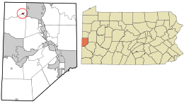
West Kittanning is a borough in Armstrong County, Pennsylvania, United States. The population was 1,192 at the 2020 census.

<span class="mw-page-title-main">Baden, Pennsylvania</span> Borough in Pennsylvania, United States

Baden is a borough in southeastern Beaver County, Pennsylvania, along the Ohio River. The population was 3,904 at the 2020 census. It is part of the Pittsburgh metropolitan area. Baden is the former site of Logstown, a significant Native American settlement.

<span class="mw-page-title-main">Big Beaver, Pennsylvania</span> Borough in Pennsylvania, United States

Big Beaver is a borough in northern Beaver County, Pennsylvania, United States. The population was 1,852 at the 2020 census. It is a part of the Pittsburgh metropolitan area. The area was originally incorporated as Big Beaver Township in 1802, and was reincorporated as a borough in 1958.

<span class="mw-page-title-main">Chippewa Township, Pennsylvania</span> Township in Pennsylvania, United States

Chippewa Township is a township in Beaver County, Pennsylvania, United States. The population was 8,040 at the 2020 census. The township shares the ZIP Code of nearby Beaver Falls. It is part of the Pittsburgh metropolitan area.

<span class="mw-page-title-main">Darlington Township, Pennsylvania</span> Township in Pennsylvania, United States

Darlington Township is a township in Beaver County, Pennsylvania, United States. The population was 1,813 at the 2020 census. It is part of the Pittsburgh metropolitan area.

<span class="mw-page-title-main">East Rochester, Pennsylvania</span> Borough in Pennsylvania, United States

East Rochester is a borough in central Beaver County, Pennsylvania, along the Ohio River. The population was 565 at the 2020 census. It is part of the Pittsburgh metropolitan area.

<span class="mw-page-title-main">Economy, Pennsylvania</span> Borough in Pennsylvania, United States

Economy is a borough in Beaver County, Pennsylvania, United States. The population was 9,098 at the 2020 census. It is a part of the Pittsburgh metropolitan area.

<span class="mw-page-title-main">Georgetown, Beaver County, Pennsylvania</span> Borough in Pennsylvania, United States

Georgetown is a borough in western Beaver County, Pennsylvania, United States, along the Ohio River. The population was 208 at the 2020 census. It is part of the Pittsburgh metropolitan area. Little Blue Run Lake, the U.S.'s largest coal slurry waste impound, is located next to the town.

<span class="mw-page-title-main">Homewood, Pennsylvania</span> Borough in Pennsylvania, United States

Homewood is a borough that is located in northern Beaver County, Pennsylvania, United States. The population was 104 at the time of the 2020 census.

<span class="mw-page-title-main">Hookstown, Pennsylvania</span> Borough in Pennsylvania, United States

Hookstown is a borough in western Beaver County, Pennsylvania, United States. The population was 129 at the time of the 2020 census. It is part of the Pittsburgh metropolitan area.

<span class="mw-page-title-main">Ohioville, Pennsylvania</span> Borough in Pennsylvania, United States

Ohioville is a borough in western Beaver County, Pennsylvania, United States. The population was 3,345 at the 2020 census. It is part of the Pittsburgh metropolitan area.

<span class="mw-page-title-main">Patterson Heights, Pennsylvania</span> Borough in Pennsylvania, United States

Patterson Heights is a borough in north-central Beaver County, Pennsylvania, United States. The population was 637 at the 2020 census. It is a part of the Pittsburgh metropolitan area.

<span class="mw-page-title-main">Shippingport, Pennsylvania</span> Borough in Pennsylvania, United States

Shippingport is a borough in western Beaver County, Pennsylvania, United States, located along the Ohio River. The population was 159 at the 2020 census. It is part of the Pittsburgh metropolitan area. Shippingport is home to the Beaver Valley Nuclear Power Station, and formerly the Bruce Mansfield Power Plant and Shippingport Atomic Power Station, the world's first full-scale atomic electric power plant devoted exclusively to peacetime uses.

<span class="mw-page-title-main">West Mayfield, Pennsylvania</span> Borough in Pennsylvania, United States

West Mayfield is a borough in northern Beaver County, Pennsylvania, United States. The population was 1,196 at the 2020 census. It is a part of the Pittsburgh metropolitan area.

<span class="mw-page-title-main">Lemont, Pennsylvania</span> Census-designated place in Pennsylvania, United States

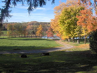
Lemont is an unincorporated community and census-designated place (CDP) in Centre County, Pennsylvania, United States, and is the location of the only remaining granary in Pennsylvania. It is part of the State College, Pennsylvania Metropolitan Statistical Area. The population was 2,270 at the 2010 census.

<span class="mw-page-title-main">New Beaver, Pennsylvania</span> Borough in Pennsylvania, United States

New Beaver is a borough in southern Lawrence County, Pennsylvania, United States. The population was 1,370 at the 2020 census. It is part of the Pittsburgh metropolitan area.

<span class="mw-page-title-main">Wind Gap, Pennsylvania</span> Borough in Pennsylvania, United States

Wind Gap is a borough in Northampton County, Pennsylvania. The population of Wind Gap was 2,820 at the 2020 census. Wind Gap is part of the Lehigh Valley metropolitan area, which had a population of 861,899 and was the 68th-most populous metropolitan area in the U.S. as of the 2020 census.

<span class="mw-page-title-main">Confluence, Pennsylvania</span> Borough in Pennsylvania, United States

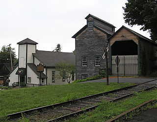
Confluence is a borough in Somerset County, Pennsylvania, United States. It is part of the Johnstown, Pennsylvania, Metropolitan Statistical Area. The population was 724 at the 2020 census.

<span class="mw-page-title-main">Roscoe, Pennsylvania</span> Borough in Pennsylvania, United States

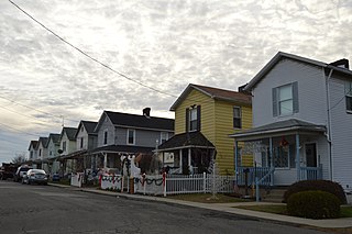
Roscoe is a borough in Washington County, Pennsylvania, United States. The population was 716 at the 2020 census.

References

  1. "ArcGIS REST Services Directory". United States Census Bureau. Retrieved October 12, 2022.
  2. 1 2 "Census Population API". United States Census Bureau. Retrieved October 12, 2022.
  3. 1 2 Bureau, US Census. "City and Town Population Totals: 2020-2021". Census.gov. US Census Bureau. Retrieved July 19, 2022.
  4. Gannett, Henry (1905). The Origin of Certain Place Names in the United States. Govt. Print. Off. pp.  100.
  5. "US Gazetteer files: 2010, 2000, and 1990". United States Census Bureau. February 12, 2011. Retrieved April 23, 2011.
  6. "Census of Population and Housing". U.S. Census Bureau. Retrieved December 11, 2013.
  7. 1 2 "U.S. Census website". United States Census Bureau . Retrieved January 31, 2008.
  8. "Incorporated Places and Minor Civil Divisions Datasets: Subcounty Resident Population Estimates: April 1, 2010 to July 1, 2012". Population Estimates. U.S. Census Bureau. Archived from the original on June 11, 2013. Retrieved December 11, 2013.
  9. "Census of Population and Housing". Census.gov. Retrieved June 4, 2016.