Ellwood City, Pennsylvania

Last updated
Ellwood City, Pennsylvania
Ewing park gazebo.jpg
Ewing Park in Ellwood City
Motto(s): 
"Changing Lives, Living Change" [1]
Beaver County Pennsylvania Incorporated and Unincorporated areas Ellwood City Highlighted.svg
Location of Ellwood City in Beaver County, Pennsylvania.
Coordinates: 40°51′40″N80°17′5″W / 40.86111°N 80.28472°W / 40.86111; -80.28472
CountryUnited States
State Pennsylvania
Counties Lawrence, Beaver
Established1892
Named for Isaac L. Ellwood
Government
  MayorTony Court
Area
[2]
  Total2.36 sq mi (6.11 km2)
  Land2.32 sq mi (6.02 km2)
  Water0.03 sq mi (0.09 km2)
Elevation
[3]
883 ft (269 m)
Population
 (2020) [4]
  Total7,642
  Density3,288.30/sq mi (1,269.58/km2)
   Demonyms
Ellwoodian
Time zone UTC-5 (Eastern (EST))
  Summer (DST) UTC-4 (EDT)
ZIP code
16117
Area code(s) 724, 878
FIPS code 42-23304 [5]
GNIS feature ID1211951 [3]
Website www.ecboro.com

Ellwood City is a borough primarily in Lawrence County, Pennsylvania, United States. With a small district extending into Beaver County, it lies along the Connoquenessing Creek just east of its confluence with the Beaver River. The population was 7,642 at the 2020 census. [6] Ellwood City lies 30 miles (48 km) northwest of Pittsburgh and 8 miles (13 km) southeast of New Castle within the Pittsburgh metropolitan area.

Contents

History

In the past, Ellwood City sustained many heavy industries such as steel tube mills, steel car works, building stone and limestone quarries, foundries and machine shops, and coal mining. Ellwood City is named after businessman Isaac L. Ellwood. [7]

Geography

Ellwood City is located at 40°51′40″N80°17′05″W / 40.860983°N 80.284849°W / 40.860983; -80.284849 (40.860983, -80.284849). [8] According to the United States Census Bureau, the borough has a total area of 2.4 square miles (6.2 km2), of which 2.3 square miles (6.0 km2) is land and 0.1 square miles (0.26 km2), or 2.09%, is water.

The (roughly) 0.3 mile-diameter Pittsburgh Circle within the city was once a bicycle-racing track, as the city historically manufactured steel for bicycles. [9]

Demographics

Historical population
CensusPop.Note
1900 2,243
1910 3,90274.0%
1920 8,958129.6%
1930 12,32337.6%
1940 12,3290.0%
1950 12,9455.0%
1960 12,413−4.1%
1970 10,857−12.5%
1980 9,998−7.9%
1990 8,894−11.0%
2000 8,688−2.3%
2010 7,921−8.8%
2020 7,642−3.5%
2021 (est.)7,564 [6] −1.0%
Sources: [5] [10] [11] [12] [4]

As of the census [5] of 2000, there were 8,688 people, 3,716 households, and 2,393 families residing in the borough. The population density was 3,716.6 inhabitants per square mile (1,435.0/km2). There were 4,006 housing units at an average density of 1,713.7 per square mile (661.7/km2). The racial makeup of the borough was 98.22% White, 0.81% African American, 0.09% Native American, 0.23% Asian, 0.18% from other races, and 0.47% from two or more races. Hispanic or Latino of any race were 0.60% of the population. In 2022, Jan Williams would become the first woman of Asian descent to be sworn into council. [13] [14]

There were 3,716 households, out of which 26.6% had children under the age of 18 living with them, 47.3% were married couples living together, 12.6% had a female householder with no husband present, and 35.6% were non-families. Of all households, 32.3% were made up of individuals, and 18.2% had someone living alone who was 65 years of age or older. The average household size was 2.32 and the average family size was 2.94.

In the borough the population was spread out, with 22.5% under the age of 18, 7.7% from 18 to 24, 26.5% from 25 to 44, 21.2% from 45 to 64, and 22.1% who were 65 years of age or older. The median age was 41 years. For every 100 females, there were 86.9 males. For every 100 females age 18 and over, there were 83.4 males.

The median income for a household in the borough was $28,926, and the median income for a family was $40,758. Males had a median income of $31,703 versus $21,285 for females. The per capita income for the borough was $15,784. About 8.6% of families and 12.3% of the population were below the poverty line, including 15.9% of those under age 18 and 11.1% of those age 65 or over.

The population at the 2010 census was 7,921, a change of -8.8% since 2000. There were 3,721 males (47.0%) and 4,200 females (53.0%). The median age was 42.0 years, compared to 40.1 for the state of Pennsylvania. [15]

The estimated median household income in 2007 was $35,555 (it was $28,926 in 2000), while in Pennsylvania it was $48,576. Estimated per capita income in 2007 was $18,674 in Ellwood City, versus $26,228 for the entire state. Estimated median house or condo value in 2007 was $91,245 (it was $75,700 in 2000), versus $155,000 for the state.[ citation needed ]

Notable people

The PBS Kids TV series Arthur takes place in the fictional town of Elwood City, based on and similar to the real Ellwood City. [17]

Related Research Articles

<span class="mw-page-title-main">Ben Avon, Pennsylvania</span> Borough in Pennsylvania, United States

Ben Avon is a borough in Allegheny County, Pennsylvania, United States, along the Ohio River. The population was 1,918 at the 2020 census. It is part of the Pittsburgh metropolitan area.

<span class="mw-page-title-main">Emsworth, Pennsylvania</span> Borough in Allegheny County, Pennsylvania, United States

Emsworth is a borough in Allegheny County, Pennsylvania, United States, along the Ohio River. The population was 2,525 at the 2020 census.

<span class="mw-page-title-main">Etna, Pennsylvania</span> Borough in Pennsylvania, United States

Etna is a borough in Allegheny County, Pennsylvania, United States, located across the Allegheny River from Pittsburgh. The population was 3,437 at the 2020 census. It is a suburb of the Pittsburgh metropolitan area.

<span class="mw-page-title-main">Glenfield, Pennsylvania</span> Borough in Pennsylvania, United States

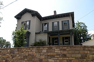
Glenfield is a borough in Allegheny County, Pennsylvania, United States, situated along the Ohio River. The population was two hundred and twelve at the time of the 2020 census.

<span class="mw-page-title-main">Leetsdale, Pennsylvania</span> Borough in Allegheny county, Pennsylvania

Leetsdale is a borough in Allegheny County, Pennsylvania, United States. Located along the Ohio River, it is part of the Pittsburgh Metro Area. The population was 1,162 at the 2020 census.

<span class="mw-page-title-main">Munhall, Pennsylvania</span> Borough in Pennsylvania, United States

Munhall is a borough in Allegheny County, Pennsylvania, United States, on the west bank of the Monongahela River. The population was 10,774 at the 2020 census. It is a residential suburb of the Pittsburgh metropolitan area.

<span class="mw-page-title-main">Rankin, Pennsylvania</span> Borough in Pennsylvania, United States

Rankin is a borough in Allegheny County, Pennsylvania, United States, 8 miles (13 km) south of Pittsburgh on the Monongahela River. The borough was named after Thomas Rankin, a local landowner. Early in the 20th century, Rankin specialized in manufacturing steel and wire goods. The population increased from 3,775 in 1900 to 7,470 in 1940 and has since declined to 1,896 as of the 2020 census.

<span class="mw-page-title-main">Ford Cliff, Pennsylvania</span> Borough in Pennsylvania, United States

Ford Cliff is a borough in Armstrong County, Pennsylvania, United States. The population was 361 at the 2020 census.

<span class="mw-page-title-main">Koppel, Pennsylvania</span> Borough in Pennsylvania, United States

Koppel is a borough in northern Beaver County, Pennsylvania, United States. The population was 712 at the 2020 census. It is part of the Pittsburgh metropolitan area.

<span class="mw-page-title-main">New Brighton, Pennsylvania</span> Borough in Pennsylvania, United States

New Brighton is a borough in north-central Beaver County, Pennsylvania, United States, located along the Beaver River 28 miles (45 km) northwest of Pittsburgh. The population was 5,729 at the 2020 census. It is part of the Pittsburgh metropolitan area.

<span class="mw-page-title-main">Spring City, Pennsylvania</span> Borough in Pennsylvania, United States

Spring City is a borough in Chester County, Pennsylvania, United States. The population was 3,494 at the 2020 census. Spring City is a member of the Spring-Ford Area School District.

<span class="mw-page-title-main">Ramey, Pennsylvania</span> Borough in Pennsylvania, United States

Ramey is a borough in Clearfield County, Pennsylvania, United States. The population was 436 at the 2020 census.

<span class="mw-page-title-main">Ellport, Pennsylvania</span> Borough in Pennsylvania, United States

Ellport is a borough in southern Lawrence County, Pennsylvania, United States. The population was 1,081 at the 2020 census. It is part of the Pittsburgh metropolitan area. The name is a portmanteau of Ellwood City and Portersville, the boroughs that lie to its west and east.

<span class="mw-page-title-main">New Beaver, Pennsylvania</span> Borough in Pennsylvania, United States

New Beaver is a borough in southern Lawrence County, Pennsylvania, United States. The population was 1,370 at the 2020 census. It is part of the Pittsburgh metropolitan area.

<span class="mw-page-title-main">Wampum, Pennsylvania</span> Borough in Pennsylvania, United States

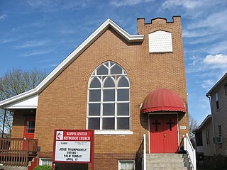
Wampum is a borough in southern Lawrence County, Pennsylvania, United States. The population was 557 at the 2020 census. It is part of the Pittsburgh metropolitan area.

<span class="mw-page-title-main">Wayne Township, Lawrence County, Pennsylvania</span> Township in Pennsylvania, United States

Wayne Township is a township in Lawrence County, Pennsylvania, United States. The population was 2,468 at the 2020 census, a decline from the figure of 2,606 tabulated in 2010.

<span class="mw-page-title-main">Claysville, Pennsylvania</span> Borough in Pennsylvania, United States

Claysville is a borough in Washington County, Pennsylvania, United States and part of the Pittsburgh metropolitan area since 1950. The population was 728 at the 2020 census. Claysville Elementary School, part of the McGuffey School District is located in Claysville. It is the birthplace of Benjamin Franklin Jones of the Jones and Laughlin Steel Company.

<span class="mw-page-title-main">Ellsworth, Pennsylvania</span> Borough in Pennsylvania, United States

Ellsworth is a borough in Washington County, Pennsylvania, United States. The population was 947 at the 2020 census. The coal town was founded by James Ellsworth, who bought the land in 1890s, developed the Monongahela Railway, and sold the mines to Bethlehem Steel in the 1920s.

<span class="mw-page-title-main">Midway, Washington County, Pennsylvania</span> Borough in Pennsylvania, United States

Midway is a borough that is located in Washington County, Pennsylvania, United States. The population was 921 at the time of the 2020 census.

<span class="mw-page-title-main">Trafford, Pennsylvania</span> Borough in Pennsylvania, United States

Trafford is a borough in Allegheny and Westmoreland counties in the U.S. state of Pennsylvania. Located near Pittsburgh in western Pennsylvania, the borough lies primarily in Westmoreland County; only a small portion extends into Allegheny County. It was incorporated in 1904 from the northernmost corner of North Huntingdon Township, and was named by George Westinghouse for Trafford near Manchester, England. Westinghouse purchased the land in 1902, and the Trafford Foundry began operations on October 3, 1903. The population was 3,317 at the 2020 census. Of this, 3,113 were in Westmoreland County, and only 61 were in Allegheny County.

References

  1. "The Borough of Ellwood City". The Borough of Ellwood City. Retrieved August 10, 2012.
  2. "ArcGIS REST Services Directory". United States Census Bureau. Retrieved October 12, 2022.
  3. 1 2 "US Board on Geographic Names". United States Geological Survey. 2007-10-25. Retrieved 2008-01-31.
  4. 1 2 "Census Population API". United States Census Bureau. Retrieved Oct 12, 2022.
  5. 1 2 3 "U.S. Census website". United States Census Bureau . Retrieved 2008-01-31.
  6. 1 2 Bureau, US Census. "City and Town Population Totals: 2020-2021". Census.gov. US Census Bureau. Retrieved 18 July 2022.
  7. "Ellwood City". www.bcpahistory.org. Retrieved 2024-04-27.
  8. "US Gazetteer files: 2010, 2000, and 1990". United States Census Bureau. 2011-02-12. Retrieved 2011-04-23.
  9. "Ellwood City". VisitPA. Retrieved 2022-05-03.
  10. "Number of Inhabitants: Pennsylvania" (PDF). 18th Census of the United States. U.S. Census Bureau. Retrieved 22 November 2013.
  11. "Pennsylvania: Population and Housing Unit Counts" (PDF). U.S. Census Bureau. Retrieved 22 November 2013.
  12. "Annual Estimates of the Resident Population". U.S. Census Bureau. Archived from the original on 2 June 2013. Retrieved 22 November 2013.
  13. Vercilla, Nicholas. "Four members of council sworn into office in Ellwood City". Ellwood City Ledger. Retrieved 2023-12-31.
  14. Jantsch, Kaisha. "The revitalization race: Council candidates look to spruce up Ellwood City". Ellwood City Ledger. Retrieved 2023-12-31.
  15. "Profile of General Population and Housing Characteristics: 2010 Demographic Profile Data (DP-1): Ellwood City borough, Pennsylvania". United States Census Bureau . Retrieved March 27, 2012.
  16. "Ellwood City honors PA Supreme Court Judge Debra McCloskey Todd" . Retrieved September 19, 2019.
  17. "Regional inspiration behind 'Arthur Adventure' books, TV show". WFMJ-TV. July 28, 2018. Retrieved March 20, 2023.