Oakwood, Pennsylvania

Last updated
Oakwood, Pennsylvania
King Avenue in Oakwood.jpg
Houses on King Avenue
Map of Oakwood, Lawrence County, Pennsylvania Highlighted.png
Location in Lawrence County
USA Pennsylvania location map.svg
Red pog.svg
Oakwood
Location in Pennsylvania
Usa edcp location map.svg
Red pog.svg
Oakwood
Location in the United States
Coordinates: 41°0′25″N80°22′35″W / 41.00694°N 80.37639°W / 41.00694; -80.37639
Country United States
State Pennsylvania
County Lawrence
Township Union
Area
[1]
  Total2.64 sq mi (6.84 km2)
  Land2.59 sq mi (6.70 km2)
  Water0.05 sq mi (0.14 km2)
Elevation
1,025 ft (312 m)
Population
 (2020) [2]
  Total2,215
  Density856.54/sq mi (330.67/km2)
Time zone UTC-4 (EST)
  Summer (DST) UTC-5 (EDT)
Area code 724
FIPS code 42-56232
GNIS feature ID2389607

Oakwood is an unincorporated area and census-designated place (CDP) in Lawrence County, Pennsylvania, United States. The population was 2,270 at the 2010 census. [3]

Contents

Geography

Oakwood is located in central Lawrence County at 41°0′25″N80°22′35″W / 41.00694°N 80.37639°W / 41.00694; -80.37639 (41.007064, -80.376461), [4] in the eastern part of Union Township. It is bordered to the east by the city of New Castle, to the northeast by Neshannock Township, to the west by Interstate 376, and to the south by the Oakland CDP in Union Township.

I-376 leads north 13 miles (21 km) to Interstate 80 near Sharon and south the same distance to the Pennsylvania Turnpike in Big Beaver. U.S. Route 224 (West State Street) is the main road through the center of Oakwood, leading east to its terminus in the center of New Castle and west 16 miles (26 km) to Boardman, Ohio, on the southern outskirts of Youngstown. U.S. Route 422 (Sampson Street) runs up the Shenango River valley along the northeastern edge of the community, leading southeast into New Castle and northwest 16 miles (26 km) to Youngstown, Ohio.

According to the United States Census Bureau, the Oakwood CDP has a total area of 2.7 square miles (6.9 km2), of which 2.6 square miles (6.8 km2) are land and 0.04 square miles (0.1 km2), of 2.01%, are water. [5] The Shenango River forms the northeastern border of the community and of Union Township. The Shenango is a southeastward-flowing tributary of the Beaver River, part of the Ohio River watershed.

Demographics

Historical population
CensusPop.Note
2020 2,215
U.S. Decennial Census [6]

As of the census [7] of 2000, there were 2,249 people, 949 households, and 664 families residing in the CDP. The population density was 877.0 inhabitants per square mile (338.6/km2). There were 978 housing units at an average density of 381.4 per square mile (147.3/km2). The racial makeup of the CDP was 94.66% White, 3.82% African American, 0.13% Asian, 0.40% from other races, and 0.98% from two or more races. Hispanic or Latino of any race were 0.76% of the population.

There were 949 households, out of which 20.3% had children under the age of 18 living with them, 54.4% were married couples living together, 12.2% had a female householder with no husband present, and 30.0% were non-families. 27.4% of all households were made up of individuals, and 16.8% had someone living alone who was 65 years of age or older. The average household size was 2.35 and the average family size was 2.84.

In the CDP the population was spread out, with 17.1% under the age of 18, 6.5% from 18 to 24, 24.3% from 25 to 44, 26.8% from 45 to 64, and 25.3% who were 65 years of age or older. The median age was 46 years. For every 100 females there were 90.1 males. For every 100 females age 18 and over, there were 87.9 males.

The median income for a household in the CDP was $32,202, and the median income for a family was $40,565. Males had a median income of $31,121 versus $21,550 for females. The per capita income for the CDP was $16,930. About 4.4% of families and 6.9% of the population were below the poverty line, including 7.2% of those under age 18 and 5.3% of those age 65 or over.

Related Research Articles

<span class="mw-page-title-main">Austintown, Ohio</span> Census-designated place in Ohio, United States

Austintown is an unincorporated community and census-designated place within Austintown Township, Mahoning County, Ohio, United States. The population was 29,594 at the 2020 census. Located directly west of Youngstown, it is a suburb of the Youngstown–Warren metropolitan area.

<span class="mw-page-title-main">South Canal, Ohio</span> Census-designated place in Ohio, United States

South Canal is an unincorporated community and census-designated place in western Newton Township, Trumbull County, Ohio, United States. The population was 1,101 at the 2020 census. It is part of the Youngstown–Warren metropolitan area.

<span class="mw-page-title-main">Iola, Pennsylvania</span> Census-designated place in Pennsylvania, United States

Iola is a census-designated place in Columbia County, Pennsylvania, United States. It is part of Northeastern Pennsylvania. The population was 144 at the 2010 census. It is part of the Bloomsburg-Berwick micropolitan area.

<span class="mw-page-title-main">Conneaut Township, Crawford County, Pennsylvania</span> Township in Pennsylvania, United States

Conneaut Township is a township in Crawford County, Pennsylvania, United States. The population was 1,339 at the 2020 census.

<span class="mw-page-title-main">North Shenango Township, Crawford County, Pennsylvania</span> Township in Pennsylvania, United States

North Shenango Township is a township in Crawford County, Pennsylvania, United States. The population was 1,278 at the 2020 census, down from 1,410 at the 2010 census.

<span class="mw-page-title-main">Pymatuning Central, Pennsylvania</span> Census-designated place in Pennsylvania, United States

Pymatuning Central is a census-designated place (CDP) in Crawford County, Pennsylvania, United States. The population was 2,269 at the 2010 census.

<span class="mw-page-title-main">Pymatuning South, Pennsylvania</span> Census-designated place in Pennsylvania, United States

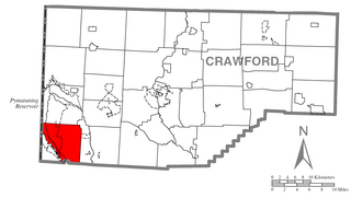
Pymatuning South is a census-designated place (CDP) in Crawford County, Pennsylvania, United States. The population was 479 at the 2010 census.

<span class="mw-page-title-main">South Shenango Township, Crawford County, Pennsylvania</span> Township in Pennsylvania, United States

South Shenango Township is a township in Crawford County, Pennsylvania, United States. The population was 1,836 at the 2020 census, down from 2,037 at the 2010 census.

<span class="mw-page-title-main">West Fallowfield Township, Crawford County, Pennsylvania</span> Township in Pennsylvania, United States

West Fallowfield Township is a township in Crawford County, Pennsylvania, United States. The population was 578 at the 2020 census, down from 605 at the 2010 census.

<span class="mw-page-title-main">West Shenango Township, Crawford County, Pennsylvania</span> Township in Pennsylvania, United States

West Shenango Township is a township in Crawford County, Pennsylvania, United States. The population was 436 at the 2020 census, down from 504 at the 2010 census.

<span class="mw-page-title-main">Progress, Pennsylvania</span> Census-designated place in Pennsylvania, United States

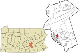
Progress is an unincorporated community and census-designated place (CDP) mainly in Susquehanna Township but also in Lower Paxton Township, Dauphin County, Pennsylvania, United States. The population was 9,765 at the 2010 census. It is part of the Harrisburg–Carlisle Metropolitan Statistical Area.

<span class="mw-page-title-main">New Castle Northwest, Pennsylvania</span> Census-designated place in Pennsylvania, United States

New Castle Northwest is an unincorporated area and census-designated place (CDP) in Lawrence County, Pennsylvania, United States. The population was 1,413 at the 2010 census.

<span class="mw-page-title-main">Oakland, Lawrence County, Pennsylvania</span> Census-designated place in Pennsylvania, United States

Oakland is an unincorporated area and census-designated place (CDP) in Lawrence County, Pennsylvania, United States. The population was 1,569 at the 2010 census.

<span class="mw-page-title-main">Hempfield Township, Mercer County, Pennsylvania</span> Township in Pennsylvania, United States

Hempfield Township is a township in Mercer County, Pennsylvania, United States. The population was 3,734 at the 2020 census, a decline from the figure of 3,741 in 2010.

<span class="mw-page-title-main">Hermitage, Pennsylvania</span> City in Pennsylvania, United States

Hermitage is a city in western Mercer County, Pennsylvania, United States. The population was 16,230 at the 2020 census, making it the largest city in Mercer County. Hermitage is located about 15 miles (24 km) northeast of Youngstown, about 65 miles (105 km) southeast of Cleveland and about 60 miles (97 km) northwest of Pittsburgh. It is part of the Youngstown–Warren metropolitan area.

<span class="mw-page-title-main">Shenango Township, Mercer County, Pennsylvania</span> Township in Pennsylvania, United States

Shenango Township is a township in Mercer County, Pennsylvania, United States. The population was 3,519 at the 2020 census, down from 3,929 in 2010.

<span class="mw-page-title-main">Sugar Grove Township, Mercer County, Pennsylvania</span> Township in Pennsylvania, United States

Sugar Grove Township is a township in Mercer County, Pennsylvania. The population was 950 at the 2020 census, a decrease from 971 in 2010.

<span class="mw-page-title-main">West Middlesex, Pennsylvania</span> Borough in Pennsylvania, United States

West Middlesex is a borough along the Shenango River in southwestern Mercer County, Pennsylvania, United States. The population was 815 at the 2020 Census. It is part of the Youngstown–Warren metropolitan area.

<span class="mw-page-title-main">Wheatland, Pennsylvania</span> Borough in Pennsylvania, United States

Wheatland is a borough in Mercer County, Pennsylvania, United States, along the Shenango River. The population was 583 at the 2020 census. It is part of the Youngstown-Warren metropolitan area.

<span class="mw-page-title-main">Howland Center, Ohio</span> Census-designated place in Ohio, United States

Howland Center, also referred to as simply Howland, is an unincorporated community and census-designated place in south-central Trumbull County, Ohio, United States. The population was 6,351 at the 2020 census. A suburb consisting of unincorporated urban portions of Howland Township, it is part of the Youngstown–Warren metropolitan area.

References

  1. "ArcGIS REST Services Directory". United States Census Bureau. Retrieved October 12, 2022.
  2. "Census Population API". United States Census Bureau. Retrieved Oct 12, 2022.
  3. "Total Population: 2010 Census DEC Summary File 1 (P1), Oakwood CDP, Pennsylvania". data.census.gov. U.S. Census Bureau. Retrieved October 8, 2020.
  4. "US Gazetteer files: 2010, 2000, and 1990". United States Census Bureau. 2011-02-12. Retrieved 2011-04-23.
  5. "2019 U.S. Gazetteer Files: Places: Pennsylvania". United States Census Bureau. Retrieved October 8, 2020.
  6. "Census of Population and Housing". Census.gov. Retrieved June 4, 2016.
  7. "U.S. Census website". United States Census Bureau . Retrieved 2008-01-31.