Bessemer, Lawrence County, Pennsylvania

Last updated
Bessemer, Pennsylvania
Bessemer, Main from Poland.jpg
Main Street downtown
Lawrence County Pennsylvania Incorporated and Unincorporated areas Bessemer Highlighted.svg
Location in Lawrence County, Pennsylvania
Coordinates: 40°58′26″N80°29′15″W / 40.97389°N 80.48750°W / 40.97389; -80.48750
CountryUnited States
State Pennsylvania
County Lawrence
Established1913
Government
  MayorNathan Leslie [1]
Area
[2]
  Total1.73 sq mi (4.48 km2)
  Land1.65 sq mi (4.28 km2)
  Water0.08 sq mi (0.20 km2)
Elevation
[3] (center of downtown)
1,086 ft (331 m)
Highest elevation
[3] (near south border)
1,222 ft (372 m)
Lowest elevation
[3] (Hickory Run)
1,040 ft (320 m)
Population
 (2020) [4]
  Total1,076
  Density650.54/sq mi (251.18/km2)
Time zone UTC-4 (EST)
  Summer (DST) UTC-5 (EDT)
ZIP code
16112
Area code 724
FIPS code 42-05936
GNIS feature ID1215351
Website bessemerpa.com

Bessemer is a borough in western Lawrence County, Pennsylvania, United States. The population was 1,073 at the 2020 census. [5] It is part of the Pittsburgh metropolitan area.

Contents

Geography

Bessemer is located at 40°58′26″N80°29′15″W / 40.97389°N 80.48750°W / 40.97389; -80.48750 (40.973960, -80.487517). [6]

According to the United States Census Bureau, the borough has a total area of 1.7 square miles (4.4 km2), of which 1.7 square miles (4.4 km2) is land and 0.1 square miles (0.26 km2), or 2.89%, is water.

Demographics

Historical population
CensusPop.Note
1920 1,417
1930 2,00141.2%
1940 1,635−18.3%
1950 1,461−10.6%
1960 1,4912.1%
1970 1,427−4.3%
1980 1,293−9.4%
1990 1,196−7.5%
2000 1,172−2.0%
2010 1,111−5.2%
2020 1,073−3.4%
2021 (est.)1,064 [5] −0.8%
Sources: [7] [8] [9] [10] [4]

As of the census [8] of 2000, there were 1,172 people, 480 households, and 345 families residing in the borough. The population density was 701.1 inhabitants per square mile (270.7/km2). There were 496 housing units at an average density of 296.7 per square mile (114.6/km2). The racial makeup of the borough was 98.55% White, 0.51% African American, 0.43% Asian, and 0.51% from two or more races. Hispanic or Latino of any race were 0.77% of the population. In 2000 census 9.5% of population related Croatian backgrounds, the highest percentage of the population of any municipality in the United States.

There were 480 households, out of which 27.7% had children under the age of 18 living with them, 55.8% were married couples living together, 12.3% had a female householder with no husband present, and 28.1% were non-families. 25.0% of all households were made up of individuals, and 15.6% had someone living alone who was 65 years of age or older. The average household size was 2.44 and the average family size was 2.91.

In the borough the population was spread out, with 22.3% under the age of 18, 6.8% from 18 to 24, 28.0% from 25 to 44, 21.2% from 45 to 64, and 21.7% who were 65 years of age or older. The median age was 40 years. For every 100 females there were 89.3 males. For every 100 females age 18 and over, there were 88.6 males.

The median income for a household in the borough was $30,781, and the median income for a family was $35,250. Males had a median income of $32,024 versus $20,069 for females. The per capita income for the borough was $15,677. About 9.1% of families and 10.0% of the population were below the poverty line, including 16.0% of those under age 18 and 4.6% of those age 65 or over.

Notable people

See also

Related Research Articles

<span class="mw-page-title-main">Blooming Valley, Pennsylvania</span> Borough in Pennsylvania, United States

Blooming Valley is a borough in Crawford County, Pennsylvania, United States. The population was 344 at the 2020 census, up from 337 at the 2010 census.

<span class="mw-page-title-main">Conneaut Lake, Pennsylvania</span> Borough in Pennsylvania, United States

Conneaut Lake is a borough in Crawford County, Pennsylvania, located at the southern end of the lake of the same name. The population was 626 at the 2020 census, down from 653 at the 2010 census.

<span class="mw-page-title-main">Springboro, Pennsylvania</span> Borough in Pennsylvania, United States

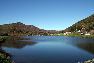
Springboro is a borough in Crawford County, Pennsylvania, United States, located 35 miles southwest of Erie. The population was 377 at the 2020 census, down from 477 at the 2010 census.

<span class="mw-page-title-main">Albion, Pennsylvania</span> Borough in Pennsylvania, United States

Albion is a borough in Erie County, Pennsylvania, United States. The population was 1,516 at the 2010 census. It is part of the Erie Metropolitan Statistical Area. One of their main industries is the Albion State Correctional Institute.

<span class="mw-page-title-main">Ellport, Pennsylvania</span> Borough in Pennsylvania, United States

Ellport is a borough in Lawrence County, Pennsylvania, United States. The population was 1,081 at the 2020 census. It is part of the Pittsburgh metropolitan area. The name is a portmanteau of Ellwood City and Portersville, the boroughs that lie to its west and east.

<span class="mw-page-title-main">Enon Valley, Pennsylvania</span> Borough in Pennsylvania, United States

Enon Valley is a borough in southern Lawrence County, Pennsylvania, United States. The population was 297 at the 2020 census. It is part of the Pittsburgh metropolitan area.

<span class="mw-page-title-main">Mahoning Township, Lawrence County, Pennsylvania</span> Township in Pennsylvania, United States

Mahoning Township is a township in Lawrence County, Pennsylvania, United States. The population was 2,709 at the time of the 2020 census, a decline from the figure of 3,083 tabulated in 2010.

<span class="mw-page-title-main">New Beaver, Pennsylvania</span> Borough in Pennsylvania, United States

New Beaver is a borough in southern Lawrence County, Pennsylvania, United States. The population was 1,370 at the 2020 census. It is part of the Pittsburgh metropolitan area.

<span class="mw-page-title-main">North Beaver Township, Lawrence County, Pennsylvania</span> Township in Pennsylvania, United States

North Beaver Township is a township in Lawrence County, Pennsylvania, United States. The population was 3,959 at the 2020 census, a decline from the figure of 4,121 tabulated in 2010.

<span class="mw-page-title-main">South New Castle, Pennsylvania</span> Borough in Pennsylvania, United States

South New Castle is a borough in central Lawrence County, Pennsylvania, United States. The population was 649 at the 2020 census. It is primarily a residential community which lies south of the city of New Castle, and is part of the Pittsburgh metropolitan area.

<span class="mw-page-title-main">Wampum, Pennsylvania</span> Borough in Pennsylvania, United States

Wampum is a borough in southern Lawrence County, Pennsylvania, United States. The population was 557 at the 2020 census. It is part of the Pittsburgh metropolitan area.

<span class="mw-page-title-main">Wayne Township, Lawrence County, Pennsylvania</span> Township in Pennsylvania, United States

Wayne Township is a township in Lawrence County, Pennsylvania, United States. The population was 2,468 at the 2020 census, a decline from the figure of 2,606 tabulated in 2010.

<span class="mw-page-title-main">Clark, Pennsylvania</span> Borough in Pennsylvania, United States

Clark is a borough in western Mercer County, Pennsylvania, United States, along the southern shore of the Shenango River Reservoir. The population was 576 at the 2020 census. It is part of the Hermitage micropolitan area.

<span class="mw-page-title-main">New Lebanon, Pennsylvania</span> Borough in Pennsylvania, United States

New Lebanon is a borough in northeastern Mercer County, Pennsylvania, United States. The population was 186 at the 2020 census. It is part of the Hermitage micropolitan area.

<span class="mw-page-title-main">Sandy Lake, Pennsylvania</span> Borough in Pennsylvania, United States

Sandy Lake is a borough in eastern Mercer County, Pennsylvania, United States. It was established in 1849. The population was 649 at the 2020 census. It is part of the Hermitage micropolitan area.

<span class="mw-page-title-main">Sheakleyville, Pennsylvania</span> Borough in Pennsylvania, United States

Sheakleyville is a borough in northern Mercer County, Pennsylvania, United States. The population was 142 at the 2010 census, a figure which increased to 150 tabulated residents in 2020. It is part of the Hermitage micropolitan area.

<span class="mw-page-title-main">Stoneboro, Pennsylvania</span> Borough in Pennsylvania, United States

Stoneboro is a borough in eastern Mercer County, Pennsylvania, United States. The population was 946 at the 2020 census. It is part of the Hermitage micropolitan area.

<span class="mw-page-title-main">Herndon, Pennsylvania</span> Borough in Pennsylvania, United States

Herndon, formerly Trevorton Junction, is a borough along the Susquehanna River in Northumberland County, Pennsylvania, United States. Herndon was first founded by Robert A. Parrish in 1840. The town was later named for Naval commander William Lewis Herndon, who died in 1857 while trying to rescue passengers from his sinking ship. The population was 324 at the 2010 census.

<span class="mw-page-title-main">Marysville, Pennsylvania</span> Borough in Pennsylvania, United States

Marysville is a borough in Perry County, Pennsylvania, United States. The population was 2,652 at the 2020 census. It is part of the Harrisburg–Carlisle Metropolitan Statistical Area.

<span class="mw-page-title-main">Galeton, Pennsylvania</span> Borough in Pennsylvania, United States

Galeton is a borough in Potter County, Pennsylvania. It is located 50 miles (80 km) southeast of Bradford, Pennsylvania. Light industries, including knitting mills and a tannery have existed in Galeton. The population declined to 993 people in 2020.

References

  1. ""Bessemer Selects Leslie as New Mayor"". New Castle News. Retrieved 2021-01-23.
  2. "ArcGIS REST Services Directory". United States Census Bureau. Retrieved October 12, 2022.
  3. 1 2 3 "Hickory Run Topo Map, Lawrence County PA (Bessemer Area)". TopoZone. Locality, LLC. Retrieved 5 September 2019.
  4. 1 2 "Census Population API". United States Census Bureau. Retrieved Oct 12, 2022.
  5. 1 2 Bureau, US Census. "City and Town Population Totals: 2020-2021". Census.gov. US Census Bureau. Retrieved 18 July 2022.
  6. "US Gazetteer files: 2010, 2000, and 1990". United States Census Bureau. 2011-02-12. Retrieved 2011-04-23.
  7. "Census of Population and Housing". U.S. Census Bureau. Retrieved 11 December 2013.
  8. 1 2 "U.S. Census website". United States Census Bureau . Retrieved 2008-01-31.
  9. "Incorporated Places and Minor Civil Divisions Datasets: Subcounty Resident Population Estimates: April 1, 2010 to July 1, 2012". Population Estimates. U.S. Census Bureau. Archived from the original on 11 June 2013. Retrieved 11 December 2013.
  10. "Census of Population and Housing". Census.gov. Retrieved June 4, 2016.