Related Research Articles

Eastvale is a borough in Beaver County, Pennsylvania, United States. The population was 183 at the 2020 census.

Millersburg is a borough in Dauphin County, Pennsylvania, United States. The population was 2,541 at the 2020 census. It is part of the Harrisburg–Carlisle Metropolitan Statistical Area.

Pine Grove Township is a township that is located in Schuylkill County, Pennsylvania, United States. The population was 4,024 at the time of the 2020 census.
Fleming is a small unincorporated community in rural eastern Barlow Township, Washington County, Ohio, United States.
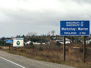
Markstay-Warren is a town in the Canadian province of Ontario, located in the Sudbury District. Highway 17, from the city limits of Greater Sudbury to the Sudbury District's border with Nipissing District, lies entirely within Markstay-Warren. The town had a population of 2,656 in the Canada 2016 Census.
Skytop is an unincorporated community in Barrett Township, Monroe County, Pennsylvania, United States. Located north of Mountainhome, it is accessible by local roads off Route 390. Its elevation is 1,562 feet (476 m), and it is located at 41°13′40″N75°14′18″W. Although Skytop is unincorporated, it has a post office, with the ZIP code of 18357; the ZCTA for ZIP Code 18357 had a population of 87 at the 2000 census.
Catawissa is a small unincorporated community in Franklin County, Missouri, United States, on the St. Louis & San Francisco Railroad, 39 miles from St. Louis and four miles south-southwest of Pacific. It is located at the junction of Route N and Route O, southwest of Pacific. Winch Creek flows past the eastern margin of the community.
Capps is an unincorporated community in Jefferson County, Florida, United States. It is located at the intersection of U.S. Routes 19 and 27.

Interstate 80 (I-80) in the US state of Ohio runs across the northern part of the state. Most of the route is part of the Ohio Turnpike; only an 18.78-mile (30.22 km) stretch is not part of the toll road. That stretch of road is the feeder route to the Keystone Shortway, a shortcut through northern Pennsylvania that provides access to New York City.

Bartlett is an unincorporated community in southwestern Wesley Township, Washington County, Ohio, United States. It has a post office with the ZIP code 45713. It sits at the intersection of State Routes 550 and 555 near Coal Run, a subsidiary of Wolf Creek, which meets the Muskingum River at Waterford to the north. Near Bartlett is located the Shinn Covered Bridge, which spans Wolf Creek.
New Somerset is an unincorporated community in northern Knox Township, Jefferson County, Ohio, United States. It lies south of Hammondsville along State Route 213, at 40°30′57″N80°42′21″W.
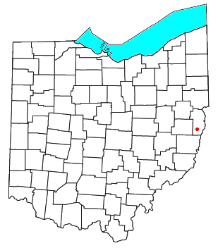
Greentown is an unincorporated community in eastern Smithfield Township, Jefferson County, Ohio, United States. It lies approximately 2 miles (3.2 km) south of Smithfield, on a small road. Part of the Dry Fork of Short Creek, a stream that meets the Ohio River at Rayland, flows past the community. It is located 11+3⁄4 miles (18.9 km) southwest of Steubenville, the county seat of Jefferson County. The community is part of the Weirton–Steubenville, WV-OH Metropolitan Statistical Area.

Roxabell is an unincorporated community in central Concord Township, Ross County, Ohio, United States. It lies at the intersection of Davis Hill and Jamison Roads, little more than 1 mile south of the village of Frankfort. Two parts of the North Fork of Paint Creek, a subsidiary of the Ohio River through the Scioto River, pass near Roxabel. It is located slightly more than 3 miles north of State Route 28, midway between the cities of Chillicothe — the county seat of Ross County — and Greenfield.

Footville is an unincorporated community in southwestern Trumbull Township, Ashtabula County, Ohio, United States. It lies at the intersection of State Route 166 with Trask Road, 1+1⁄2 miles (2.4 km) east of the Geauga County line and 11+1⁄4 miles (18.1 km) southeast of the village of Jefferson, the county seat of Ashtabula County. Spring and Trumbull Creeks, which are both tributaries of the Grand River, pass near Footville.

College Hill is a neighborhood located in the northern section of Beaver Falls, Pennsylvania, United States. Geneva College is located in the community, and is the namesake of College Hill.

Fombell is an unincorporated community that includes both Franklin Township and Marion Township, Beaver County, Pennsylvania, United States. Its U.S. postal zip code is 16123. Its elevation ranges from 879 feet (268 m) along the creek to 1280 feet on top of the hills, and it is located at 40°48′34″N80°12′6″W.

Cassella is an unincorporated community in Marion Township, Mercer County, Ohio, United States. Located at 40°24′22″N84°33′8″W, it lies at an elevation of 955 feet (291 m). Situated at the intersection of State Route 119 and Cassella-Montezuma Road in western Marion Township, it lies in the headwaters of Beaver Creek to the south of the city of Celina, the county seat of Mercer County. Other nearby communities include Maria Stein, 3 miles (4.8 km) to the east, Carthagena, 2 miles (3.2 km) to the north, and St. Henry, 4 miles (6.4 km) to the west.
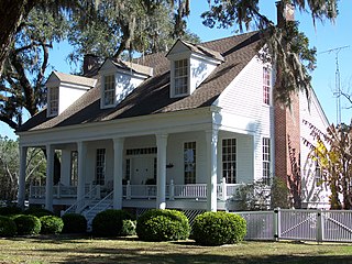
Milburn is an unincorporated community in Carlisle County, Kentucky, United States. Its elevation is 482 feet (147 m), and it is located at 36°47′55″N88°53′59″W. Located along Kentucky Route 80 at its junction with Kentucky Routes 1371 and 1377, Milburn lies amid rolling countryside at the headwaters of Guess Creek, a tributary of Bayou du Chien; the nearest point on the Mississippi River is approximately 12 miles (19 km) to the west. Nearby cities include Arlington, 6 miles (9.7 km) by air to the west, and Bardwell, 8 miles (13 km) by air to the northwest; Milburn is connected to them by Kentucky Route 80 and Kentucky Route 1377 respectively. A state hunting preserve, the Obion Creek Wildlife Management Area, lies 2 miles (3.2 km) to the south. A fire station is located in Milburn, and a Creole cottage in the community, the George W. Stone House, is listed on the National Register of Historic Places.
Peddler Creek is a stream in Gentry and Worth counties in the U.S. state of Missouri. It is a tributary of the Middle Fork of the Grand River.
Martinstown is an unincorporated community in southeast Putnam County, in the U.S. state of Missouri.
References
- ↑ DeLorme. Pennsylvania Atlas & Gazetteer. 8th ed. Yarmouth: DeLorme, 2003, 56. ISBN 0-89933-280-3.

