De Biesbosch National Park

Last updated
De Biesbosch National Park
Nationaal Park De Biesbosch
Biesbosch 1.jpg
Hollandse Biesbosch near Dordrecht, Netherlands
BiesboschKaart.png
Map of the National Park
LocationMunicipalities: Altena, Dordrecht, Drimmelen, Geertruidenberg
Provinces: North Brabant, South Holland
Country: Netherlands
Nearest city Dordrecht, Netherlands
Coordinates 51°44′N4°45′E / 51.733°N 4.750°E / 51.733; 4.750
Area90 km2 (35 sq mi)
Established1994
Governing body Staatsbosbeheer
www.biesbosch.org
Official nameBiesbosch
Designated23 May 1980
Reference no.197 [1]
Sunset over the Biesbosch 1-PC260064-001 Nationaal Park De Biesbosch.JPG
Sunset over the Biesbosch
Air view over the Biesbosch. Biesbosch 20050928 40011.JPG
Air view over the Biesbosch.

De Biesbosch National Park is one of the largest national parks in the Netherlands [2] and one of the last extensive areas of freshwater tidal wetlands in Northwestern Europe. The Biesbosch ('forest of sedges' or 'rushwoods') consists of a large network of rivers and smaller and larger creeks with islands. The vegetation is mostly willow forests, although wet grasslands and fields of reed are common as well. [3] The Biesbosch is an important wetland area for waterfowl and has a rich flora and fauna. It is especially important for migrating geese.

Contents

Structure

National Park

Simple map of the Biesbosch. Biesbosch Kaart.jpg
Simple map of the Biesbosch.

The Biesbosch National Park consists of the following major parts:

The most northern part of the Biesbosch. This is the part of the Biesbosch with the most significant tidal influence (one of the distinctive characteristics of the Biesbosch). The Sliedrechtse Biesbosch is named after the town of Sliedrecht, which was drowned during the creation of the Biesbosch and was later rebuilt on the other side of the river Beneden Merwede (one of the borders of the Biesbosch). The eastern part of the Sliedrechtse Biesbosch is one of the few areas in the Netherlands that has an intact system of river dunes.

The westernmost part of the Biesbosch and the largest remnant of the (once much larger) South Hollandic part of the Biesbosch. The Hollandse Biesbosch is the part of the National Park best known for its birds.

Map showing the parts of the Biesbosch that make up the National Park (highlighted). BiesboschKaart.png
Map showing the parts of the Biesbosch that make up the National Park (highlighted).

The eastern and largest part of the Biesbosch, which is separated from the rest of the Biesbosch by the Nieuwe Merwede river (which serves as the borderline between the provinces of South Holland and North Brabant). The Brabantse Biesbosch can be divided in three parts, from which only the so-called Zuidwaard belongs to the National Park. The Zuidwaard of the Brabantse Biesbosch has fewer fields of reeds and sedges compared to the rest of the National Park and consists mostly of willow forests.

Other

The National Park occupies only half of the original Biesbosch area. The other half has been reclaimed and consists mostly of farmland. It can be divided in several parts as well:

The part of the Biesbosch that borders the city of Dordrecht. It is located between the Sliedrechtse Biesbosch and the Hollandse Biesbosch. Although the Dordtse Biesbosch has largely an agricultural destination, it also contains several recreational areas which serves as the "playground" for the people of Dordrecht.

Creek remnant in the Biesbosch. Nationaal Park De Biesbosch.jpg
Creek remnant in the Biesbosch.

The most central part of the Biesbosch and the subject of much recent controversy. The Noordwaard has only been reclaimed during the 20th century and hosts some of most fertile farmlands in the entire Netherlands. However, as a result of the high water levels in the Dutch rivers during the 1990s, the government has decided to undo the reclamation and reconnect the Noordwaard to the Merwede rivers (essentially the Rhine). In this way it can serve as a buffer and be of much importance in the prevention of dike breaks and subsequent flooding in densely populated areas in the Rhine-Meuse-Scheldt delta. The first phase of the "de-poldering" has been completed by 2008 and the resulting wetlands have been added to the National Park. The second phase will be completed somewhere between 2015 and 2020.

The easternmost and oldest part of the Biesbosch does not resemble the rest of the Biesbosch and consists mainly of farmland and expanded neighbourhoods of towns along the Biesbosch border (such as Werkendam, Nieuwendijk and Hank), along with a few creek remnants. Much of the Oostwaard has been reclaimed during the 17th and 18th centuries.

Creation

The Biesbosch was created when 300 square kilometres of polder lands were submerged in the St. Elizabeth flood in the year 1421. Before this, the area was called Grote Hollandse Waard, containing cultivated land and a number of villages. The more than a century old dikes collapsed because of lack of maintenance, due to the difficult economic situation in the area, and the difficulties between the political entities within (especially the Hook and Cod (civil) wars).

The Grote Waard in 1421, just before the St. Elizabeth flood. Groote Waard.jpg
The Grote Waard in 1421, just before the St. Elizabeth flood.

One of the key factors in the flooding of the Grote Waard was the creation of a new dike in the southwest of the polder. The ground beneath this dike was unstable, which was a known (but underestimated) fact in this period of time. However, combined with political rivalry and financial issues, this resulted in the creation of an unstable dike, located at one of the key corners of the Grote Waard. It was the only place where high tides coming directly from the sea could penetrate the land deeply and could reach a primary "keystone" dike of the Grote Waard (most of the primary dikes were used as protection against rivers instead).

Biesbosch wetlands. Biesbosch wetlands.jpg
Biesbosch wetlands.

Very high river levels combined with a severe storm surge coming in from the sea caused the collapse of the southwest dike and several riverdikes, resulting in the flooding of most of the Grote Hollandse Waard. After the flood, three areas remained: the Island of Dordrecht to the west, the Land van Altena (with the city of Woudrichem) to the east, and the brackish swamps of the Biesbosch in between. Many villages (by tradition 72) were swallowed by the flood and were lost, causing (again by tradition) either 2,000 or 10,000 casualties. Some towns had more luck and submerged, only to rise above the water later on.

Many Rhine-Meuse delta branches that were closed off from the main rivers and served as drainage bodies of the Grote Waard, also disappeared. These include the Dubbel (the name of which survives in Dubbeldam), Eem, Werken (after which Werkendam is named), Graaf, Alm (which lent its name to Almkerk; the eastern part survived) and most of the main drainage stream: the Oude Maas (a small part survives in the form of the Oude Maasje, not to be confused with another branch called Oude Maas near Rotterdam).

Most of the flooded area changed into a network of estuaries. The most important of those were the Hollands Diep ("Holland Deep") and the (shallow) Heidezee ("Heath Sea"). Both were connected to the Haringvliet which existed before the disaster as a pure seawater inlet of the North Sea. After the disaster it became brackish and an important estuary of the rivers Rhine and Meuse. A persistent misunderstanding is that the Biesbosch arose by this storm flood in one night. It is true that this flood broke dikes of the then Grote Hollandse Waard or Zuid Hollandse Waard, but it needed dozens of years before the whole area was under water and had changed to the Biesbosch with its creeks and reeds.

History

Biesbosch at low tide. Biesbosch 2.jpg
Biesbosch at low tide.

At first, the Heidezee was a shallow but extended body of water, with high tides but also a predominance of fresh water. The deposits of the rivers caused the land to become only submerged at high tides. From that moment on the area was called the Bergse Veld ("Fields of Geertruidenberg") and, later on (during the 18th century), the Biesbosch (although a small patch of swamp had been known as Biesbosch even before the flood). A network of interconnecting creeks, mudflats and forested areas arose, which served as a sort of inland delta of the large rivers feeding it. A significant result of this was that the former estuary arms of the Rhine and Meuse, further north-west, were devoid of much of the inflow of fresh water. This caused the rivers to fill with deposits, so the important shipping route between Rotterdam and the inland areas was no longer usable.

During the last centuries, conditions changed significantly. Most of the Biesbosch was reclaimed and turned into polders. The Rhine-Meuse connection with Rotterdam was restored by preventing the build-up of deposits by artificial means. Most of the Biesbosch creeks were closed off at their upstream end to lower the risk of flooding. The confluence of the Meuse and Rhine rivers was closed off as well and the Meuse received a new, artificial mouth: the Bergse Maas. By separating rivers Meuse and Rhine before they reach the Biesbosch, their flow can be controlled better. A second ship canal was created to better distribute the flow of the river Rhine as well: the Nieuwe Merwede, which divides the Biesbosch into two parts: the "lesser" Biesbosch, now the southeastern part of the Island of Dordrecht, and the "greater" Biesbosch. As a result of these hydrological changes, the Biesbosch lost its function as a river delta and now only receives water directly from the rivers in times of high discharges.

During World War II, the area was used by Dutch residents to hide out from the German occupation forces in the Netherlands. A resistance group was formed that, late in the war, captured Germans fleeing to the north from what was then the Allied-held south of the Netherlands. In the winter of 1944, the area was crossed by refugees from the occupied north, while, at the same time, it was being used to smuggle medicines to the north. The people that coordinated these activities are known as the Biesbosch crossers and are commonly regarded as national heroes. Many Dutch books and a few movies are based on this resistance group.

Before 1970 a connection with the sea existed, and the tidal differences were, on average, two meters. Despite the diminished inflow of the Meuse and Waal rivers, fresh water continued to dominate. The tidal differences almost disappeared after 1970 when the Delta Works closed the Haringvliet and with it the Biesbosch's direct connection with the sea. Only in the northern part of the Biesbosch (the so-called Sliedrechtse Biesbosch) some of the tidal difference remained (20–80 cm on average). The diminishing of the tidal difference caused a dramatic transformation of the Biesbosch, which mostly changed into a willow forest with small remnants of the once mighty delta streams. The creation of the Haringvlietdam also blocked the main route for migrating fish. The influence of both rivers and sea had now mostly gone.

Future

The Dutch government has decided to undo most of the reclamation and give it back to nature and to reconnect the main rivers with the Biesbosch creeks. This decision has been made as a result of extremely high river discharges in 1993 and 1995. This means that a large part of the Biesbosch will return to its original state: an interconnected network of rivers and creeks, serving as an inland river delta. The area can then be used as a natural buffer to prevent major floods and to lower the risk of very high river levels. For example, the Noordwaard polder in the Biesbosch was reconnected with the Merwede river, to allow flooding during peak discharges of the Rhine and Meuse rivers and to reintroduce sediments which resulted in land aggradation rate of 5.1 mm. [4] [5] The latter is called a sedimentation enhancing strategy. Such strategies will also restore some of the natural situation and will result in an expansion of the habitat of many animals.

Air view of parts of the Biesbosch Biesbosch 20050928 40011.JPG
Air view of parts of the Biesbosch

Especially the beaver population could profit from these hydrological changes (and, as of 2014, they indeed expanded their range significantly). It would also hopefully create the right conditions for the return of the osprey and the white-tailed eagle as breeding birds. Because of recent nature development of new wetlands the great egret and the little egret have already become familiar elements in the Biesbosch today. There is also an increase in the population of bitterns and kingfishers. Moreover, as of 2014 a couple of white-tailed eagles has been breeding in the Biesbosch for several years in a row. Ospreys have been using the Biesbosch as a feeding ground for several years now, with as a result the first Dutch-born Ospreys in the spring of 2016. [6]

There are also plans to restore the estuary function of the Haringvliet and Hollands Diep, restoring the natural shift from fresh to salty water and allow the return of the tides in the Biesbosch. A first step will be opening some of the sluices of the Haringvlietdam. This will result in a minimal return of tidal effects without having a dramatic impact on the landscape, because a full opening of the dam will make most of the surrounding farming areas unusable, as a result of the influx of salty water. One should note the fact that in times of severe floods coming from the North Sea, the dam will still be able to close and serve in a similar way as the Oosterscheldekering.

The partial opening of the Haringvlietdam will create an opportunity for migrating fish to enter the Rhine and Meuse rivers, restoring the natural situation. This will hopefully result in the return of the salmon, trout, shad, smelt and many other species of fish. It will also create opportunities for the almost extinct southern Dutch population of seals (now mostly restricted to parts of the Oosterschelde). Seals used to be a common sight in the Biesbosch despite the fact that the area is dominated by freshwater. Their presence ended in 1970, although a few individuals somehow managed to reach the Biesbosch afterwards. The partial opening of the Haringvlietdam will restore some of the natural situation.

In the future possibly moose will be re-introduced in the area. [7]

Threats

Typical Biesbosch creek. Biesbosch kreek.jpg
Typical Biesbosch creek.

The area still faces many threats. One of them is the pollution of water and soil. Many streambeds contain severely polluted sediments, a remainder from the sixties and seventies, when the rivers Rhine and Meuse were much more polluted than they are today. Because there is little net flow in the Biesbosch (because the connection with both rivers and the sea has been blocked, although this will change in the future) the build-up of polluted sediments in the Biesbosch has been severe. Completely restoring the Biesbosch ecosystem cannot happen without an extensive cleanup of all the creeks, which will be an enormous and costly task.

Another threat to the Biesbosch ecosystem is the extensive water recreation in the area. The Biesbosch has, however, both strong natural and recreational values, so banning all recreational activities in the area is not an option. Finding the right balance in this issue will be a challenge. Other threats include the construction of yacht-basins, urban expansion and plans for exploitation of natural gas reserves.

Related Research Articles

<span class="mw-page-title-main">Meuse</span> River in western Europe

The Meuse or Maas is a major European river, rising in France and flowing through Belgium and the Netherlands before draining into the North Sea from the Rhine–Meuse–Scheldt delta. It has a total length of 925 km.

<span class="mw-page-title-main">Rhine</span> Major river in Western Europe

The Rhine is one of the major European rivers. The river begins in the Swiss canton of Graubünden in the southeastern Swiss Alps. It forms part of the Swiss-Liechtenstein, Swiss-Austrian, and Swiss-German borders. After that the Rhine defines much of the Franco-German border, after which it flows in a mostly northerly direction through the German Rhineland. Finally in Germany, the Rhine turns into a predominantly westerly direction and flows into the Netherlands where it eventually empties into the North Sea. It drains an area of 9,973 sq km and its name derives from the Celtic Rēnos. There are also two German states named after the river, North Rhine-Westphalia and Rhineland-Palatinate.

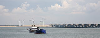
The Delta Works is a series of construction projects in the southwest of the Netherlands to protect a large area of land around the Rhine–Meuse–Scheldt delta from the sea. Constructed between 1954 and 1997, the works consist of dams, sluices, locks, dykes, levees, and storm surge barriers located in the provinces of South Holland and Zeeland.

<span class="mw-page-title-main">Goeree-Overflakkee</span> Island and Municipality in South Holland, Netherlands

Goeree-Overflakkee is the southernmost delta island of the province of South Holland, Netherlands. It is separated from Voorne-Putten and Hoeksche Waard by the Haringvliet, from the mainland of North Brabant by the Volkerak, and from Schouwen-Duiveland by Lake Grevelingen.

<span class="mw-page-title-main">Hollands Diep</span> Estuary of the Rhine and Meuse rivers in South Holland, Netherlands

Hollands Diep is a river in the Netherlands, and an estuary of the Rhine and Meuse rivers. Through the Scheldt-Rhine Canal it connects to the Scheldt river and Antwerp.

<span class="mw-page-title-main">Haringvliet</span> Inlet of the North Sea

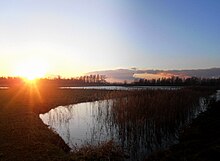
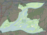
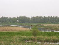
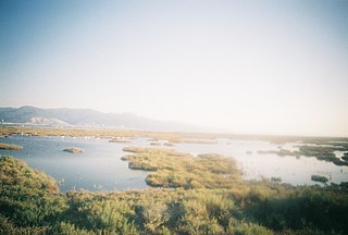
The Haringvliet is a large inlet of the North Sea, in the province of South Holland in the Netherlands. It is an important estuary of the Rhine-Meuse delta.

<span class="mw-page-title-main">Nieuwe Merwede</span> Canal in the Netherlands

The Nieuwe Merwede is a Dutch canal, mainly fed by the river Rhine, that was constructed in 1870 to form a branch in the Rhine–Meuse delta. It was dug along the general trajectories of a number of minor Biesbosch creeks to reduce the risk of flooding by diverting the water away from the Beneden Merwede, and to facilitate navigation and regulate river traffic in the increasingly silted-up delta.

<span class="mw-page-title-main">St. Elizabeth's flood (1421)</span> Flooding of the Grote Hollandse Waard, an area in what is now the Netherlands

The St. Elizabeth's flood of 1421 was a flooding of the Grote Hollandse Waard, an area in what is now the Netherlands. It takes its name from the feast day of Saint Elisabeth of Hungary which was formerly 19 November. It ranks 20th on the list of worst floods in history. During the night of 18/19 November 1421 a heavy storm near the North Sea coast caused the dikes to break in a number of places and the lower-lying polder land was flooded. A number of villages were swallowed by the flood and were lost, causing between 2,000 and 10,000 casualties. The dike breaks and floods caused widespread devastation in Zeeland and Holland.

<span class="mw-page-title-main">Grote Hollandse Waard</span> Former farming region in the County of Holland, Netherlands

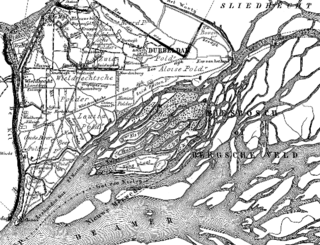
The Grote Waard or Hollandse Waard was a farming region in the County of Holland at the border of the Duchy of Brabant, that disappeared in the St. Elizabeth's flood. Parts of this polder are now separated by water: Hoekse Waard, Eiland van Dordrecht, De Biesbosch, and parts of North Brabant. The Grote Waard was a damp peat region, which was roughly limited by what now is the Afgedamde Maas between Heusden and Woudrichem, the Boven Merwede and Beneden Merwede, Dordrecht, Maasdam, the Keizersdijk between Maasdam and Strijen, Strijensas, Lage Zwaluwe, and Hooge Zwaluwe.

<span class="mw-page-title-main">Flood control in the Netherlands</span> Manmade control of flooding in the Netherlands

Flood control is an important issue for the Netherlands, as due to its low elevation, approximately two thirds of its area is vulnerable to flooding, while the country is densely populated. Natural sand dunes and constructed dikes, dams, and floodgates provide defense against storm surges from the sea. River dikes prevent flooding from water flowing into the country by the major rivers Rhine and Meuse, while a complicated system of drainage ditches, canals, and pumping stations keep the low-lying parts dry for habitation and agriculture. Water control boards are the independent local government bodies responsible for maintaining this system.

<span class="mw-page-title-main">Merwede</span> River in the Netherlands

The Merwede is the name of several connected stretches of river in the Netherlands, between the cities of Woudrichem, Dordrecht and Papendrecht. The river is part of the Rhine–Meuse–Scheldt delta and is mostly fed by the river Rhine.

<span class="mw-page-title-main">Haringvlietdam</span> Bridge in Voorne-Putten, Goeree-Overflakkee

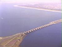
The Haringvlietdam, incorporating the Haringvliet sluices, are hydraulic engineering structures which closed off the estuary of the Haringvliet, Netherlands, as part of the Delta Works. The structure consists of 17 sluices, several kilometres of dam and a shipping lock, and formed the sixth project of the Delta Works.

<span class="mw-page-title-main">Water board (Netherlands)</span> Water management authorities in the Netherlands

In the Netherlands, a water board, water council or water authority is a regional governing body solely charged with the management of surface water in the environment. Water boards are independent of administrative governing bodies like provinces and municipalities. In general, they are responsible for managing rivers and canals, issues with the flow of watercourses and drainage issues, water collection, flood and erosion prevention and provision of potable water. They manage polder systems, water levels, water barriers and locks, enforcements, water quality and sewage treatment in their respective regions. The concept of a coordinating "High Water Authority" (Hoogheemraadschap) originated in what now is the province of South Holland in the 12th century.

<span class="mw-page-title-main">Rhine–Meuse–Scheldt delta</span> Delta formed by 3 rivers in the Netherlands

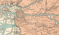
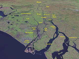
The Rhine–Meuse–Scheldt delta is a river delta in the Netherlands formed by the confluence of the Rhine, the Meuse and the Scheldt rivers. In some cases, the Scheldt delta is considered a separate delta to the Rhine–Meuse delta. The result is a multitude of islands, branches and branch names, in which a waterway that appears to be one continuous stream may have numerous separate names for different sections, e.g. Rhine → Bijlands Kanaal → Pannerdens Kanaal → Nederrijn → Lek → Nieuwe Maas → Het Scheur → Nieuwe Waterweg. Since the Rhine contributes most of the water, the term "Rhine Delta" is commonly used, although this name is also used for the delta where the Alpine Rhine flows into Lake Constance. By some calculations, the Rhine–Meuse–Scheldt delta covers 25,347 km2 (9,787 sq mi), making it the largest in Europe.

<span class="mw-page-title-main">Oude Maas</span> Distributary of the Rhine River in South Holland, Netherlands

The Oude Maas is a distributary of the river Rhine, and a former distributary of the river Maas, in the Dutch province of South Holland. It begins at the city of Dordrecht where the Beneden Merwede river splits into the Noord and the Oude Maas. It ends when it joins the Nieuwe Maas to form Het Scheur.

<span class="mw-page-title-main">Sedimentation enhancing strategy</span>

Sedimentation enhancing strategies are environmental management projects aiming to restore and facilitate land-building processes in deltas. Sediment availability and deposition are important because deltas naturally subside and therefore need sediment accumulation to maintain their elevation, particularly considering increasing rates of sea-level rise. Sedimentation enhancing strategies aim to increase sedimentation on the delta plain primarily by restoring the exchange of water and sediments between rivers and low-lying delta plains. Sedimentation enhancing strategies can be applied to encourage land elevation gain to offset sea-level rise. Interest in sedimentation enhancing strategies has recently increased due to their ability to raise land elevation, which is important for the long-term sustainability of deltas.

<span class="mw-page-title-main">Volkerakdam</span> Hydraulic engineering structures in the Netherlands

The Volkerakdam or Volkerakwerken is the name given to a group of hydraulic engineering structures located between Goeree-Overflakkee and North Brabant in The Netherlands. The works are not a single dam, but are composed of three distinct structures: a dam between Goeree-Overflakkee and Hellegatsplein, a series of locks from Hellegatsplein to North Brabant, and a bridge from Hellegatsplein to Hoekse Waard. The works cross three separate bodies of water: the Haringvliet, Hollands Diep and Volkerak. The works together comprise the fifth project of the Delta Works.

<span class="mw-page-title-main">Grevelingendam</span> Hydraulic engineering structures in the Netherlands

The Grevelingendam is a dam located in the Grevelingen sea inlet between Schouwen-Duiveland and Goeree-Overflakkee in The Netherlands. The Grevelingendam was the fourth structure constructed as part of the Delta Works.

<span class="mw-page-title-main">Stormvloedkering Hollandse IJssel</span> Hydraulic engineering structure in the Netherlands

The Stormvloedkering Hollandse IJssel, Hollandse IJsselkering or Algerakering is a storm surge barrier located on the Hollandse IJssel, at the municipal boundary of Capelle aan den IJssel and Krimpen aan den IJssel, east of Rotterdam in The Netherlands. The construction of the works comprised the first project of the Delta Works, undertaken in response to the disastrous effects of the North Sea flood of 1953. Prior to 1954, the spelling Hollandsche was used in the official name.

References

  1. "Biesbosch". Ramsar Sites Information Service. Retrieved 25 April 2018.
  2. "Samenwerkingsverband Nationale Parken" (in Dutch).
  3. "Planten in de Biesbosch" (in Dutch). Archived from the original on 2014-10-16.
  4. van der Deijl, E. C.; van der Perk, M.; Middelkoop, H. (2018). "Establishing a sediment budget in the newly created "Kleine Noordwaard" wetland area in the Rhine–Meuse delta" (PDF). Earth Surface Dynamics. 6 (1): 187–201. doi: 10.5194/esurf-6-187-2018 . ISSN   2196-632X.
  5. van der Deijl, E. C.; van der Perk, M.; Middelkoop, H. (2019). "Pathways of Water and Sediment in the Biesbosch Freshwater Tidal Wetland". Wetlands. 39 (1): 197–215. doi: 10.1007/s13157-018-1071-0 . ISSN   0277-5212.
  6. "Primeur: Eerste visarend(en) in Nederland geboren".
  7. Elanden in de Biesbosch - ARK Natuurontwikkeling