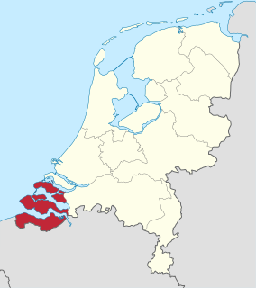
Zeeland is the westernmost and least populous province of the Netherlands. The province, located in the south-west of the country, borders North Brabant to the east and South Holland to the north. It consists of a number of islands and peninsulas and a strip bordering the Flemish provinces of East and West Flanders. Its capital is Middelburg with a population of 48,544 as of November 2019, the largest municipality in Zeeland is Terneuzen. Zeeland has two seaports: Vlissingen and Terneuzen. Its area is 2,934 square kilometres (1,130 sq mi), of which 1,151 square kilometres (440 sq mi) is water, and it has a population of 383,689 as of November 2019.

The Delta Works is a series of construction projects in the southwest of the Netherlands to protect a large area of land around the Rhine-Meuse-Scheldt delta from the sea. Constructed between 1954 and 1997, the works consist of dams, sluices, locks, dykes, levees, and storm surge barriers located in the provinces of South Holland and Zeeland.

The Eastern Scheldt is a former estuary in the province of Zeeland, Netherlands, between Schouwen-Duiveland and Tholen on the north and Noord-Beveland and Zuid-Beveland on the south. It has also the largest national park in the Netherlands, founded in 2002.

Neeltje Jans is an artificial island in the Netherlands in the province of Zeeland, halfway between Noord-Beveland and Schouwen-Duiveland in the Oosterschelde. It was constructed to facilitate the construction of the Oosterscheldedam.

The Scheldt is a 350-kilometre-long (220 mi) river that flows through in northern France, western Belgium, and the southwestern part of the Netherlands, with its mouth at the North Sea. Its name is derived from an adjective corresponding to Old English sceald ("shallow"), Modern English shoal, Low German schol, West Frisian skol, and Swedish (obsolete) skäll ("thin").

Walcheren is a region and former island in the Dutch province of Zeeland at the mouth of the Scheldt estuary. It lies between the Eastern Scheldt in the north and the Western Scheldt in the south and is roughly the shape of a rhombus. The two sides facing the North Sea consist of dunes and the rest of its coastline is made up of dykes. Middelburg, the provincial capital, lies at Walcheren's center. Vlissingen, 9 kilometres (5.6 mi) to the south, is the main harbour and the third municipality is Veere.

Noord-Beveland is a municipality and region in the southwestern Netherlands and a former island, now part of the Walcheren-Zuid-Beveland-Noord-Beveland peninsula. Noord-Beveland is enclosed by the Oosterschelde estuary to the north, and the former straits, now combined lake, of Veerse Meer and Zandkreek to the south. As part of the Delta Works, dams have connected Noord-Beveland to Walcheren and Zuid-Beveland.

The Western Scheldt in the province of Zeeland in the southwestern Netherlands, is the estuary of the Scheldt river. This river once had several estuaries, but the others are now disconnected from the Scheldt, leaving the Westerschelde as its only direct route to the sea. The Western Scheldt is an important shipping route to the Port of Antwerp, Belgium. Unlike the Eastern Scheldt estuary, it could not be closed off from the sea by a dam as part of the Delta Works. Instead, the dykes around it have been heightened and reinforced.

Zeelandic Flanders is the southernmost region of the province of Zeeland in the south-western Netherlands. It lies south of the Western Scheldt that separates the region from the remainder of Zeeland and the Netherlands to the north. Zeelandic Flanders is bordered to the south by Belgium.

Zuid-Beveland is part of the province of Zeeland in the Netherlands north of the Western Scheldt and south of the Eastern Scheldt.
The Scheldt–Rhine Canal (Schelde-Rijnkanaal) in Belgium and the Netherlands connects Antwerp with the Volkerak, and thereby the Scheldt with the Rhine.

The Zeeland Bridge is the longest bridge in the Netherlands. The bridge spans the Oosterschelde estuary. It connects the islands of Schouwen-Duiveland and Noord-Beveland in the province of Zeeland.

Yerseke is a village situated on the southern shore of the Oosterschelde estuary in the Dutch province of Zeeland. A separate municipality until 1970, it today forms part of the municipality of Reimerswaal. As of 2010 Yerseke had a recorded population of 6,695 inhabitants, living in 2,680 households.

Het Verdronken Land van Reimerswaal is an area of flood-covered land in Zeeland in the Netherlands between Noord Beveland and Bergen op Zoom. Some of it was lost in the St. Felix's Flood in 1530, and some of it in 1532. The Oosterschelde formerly flowed along its east and north edges. It is sometimes divided into the "Verdronken Land van Zuid-Beveland" and the "Verdronken Land van de Markiezaat van Bergen op Zoom". Verdronken is Dutch for "drowned", and Markizaat van Bergen op Zoom is the marquisate of Bergen op Zoom).

Kats is a town in the Dutch province of Zeeland. It is a part of the municipality of Noord-Beveland, and lies about 20 km east of Middelburg.
Wemeldinge is the oldest village in the Zuid-Beveland area of the Dutch province of Zeeland. It is located in the municipality of Kapelle, about 4 km northwest of Yerseke. It is located within the Eastern Scheldt national park.

The Veerse Meer is a lagoon in the southwest Netherlands in the province of Zeeland.
The Sloedam was a dam, connecting the Dutch islands Zuid-Beveland and Walcheren near the town of Arnemuiden. Before the dam was constructed, these islands were separated by a stretch of water called the Sloe. The Sloedam was constructed in 1871 for the railway connection between the towns of Flushing and Roosendaal, the so-called Zeeuwse Lijn. After World War II, the areas to the south of the dam were poldered. Since the Veerse Gat estuary was closed off by the Veerse Gatdam in 1961, the Sloedam no longer functions as a primary defense against the sea.

In August 1572, during the course of the Eighty Years' War, the city of Goes, in the Spanish Netherlands, was besieged by Dutch forces with the support of English troops sent by Queen Elizabeth I. This was a menace to the safety of the nearby city of Middelburg, also under siege. Given the impossibility of rescue of Goes by sea, 3,000 soldiers of the Spanish Tercios under the command of Cristóbal de Mondragón waded across the river Scheldt at its mouth, walking 15 miles overnight in water up to chest deep. The surprise arrival of the Tercios forced the withdrawal of the Anglo-Dutch troops from Goes, allowing the Spanish to maintain control of Middelburg, capital of Walcheren Island.

The Markiezaatskade is a 4 km (2.5 mi) long dam between Zuid-Beveland and the Molenplaat near Bergen op Zoom. The dam was built in preparation for the construction of the Oesterdam, which was built a few years later. In combination with the Oesterdam, Philipsdam and Volkerakdam it divides the waters of Zeeland and South Holland.

