Porto Seguro, is a city located in the far south of Bahia, Brazil. The city has an estimated population of 150,658 (2020), covers 2,287 square kilometres (883 sq mi), and has a population density of 52.7 residents per square kilometer. The area that includes Porto Seguro and neighbouring Santa Cruz Cabrália and Eunápolis holds a distinctive place in Brazilian history: in 1500 it was the first landing point of Portuguese navigators, principally Pedro Álvares Cabral. The crime rate is considered high, as is the case in the rest of Bahia.

Abel Tasman National Park is a New Zealand national park located between Golden Bay and Tasman Bay / Te Tai-o-Aorere at the north end of the South Island. It is named after Abel Tasman, who in 1642 became the first European explorer to sight New Zealand and who anchored nearby in Golden Bay.

Volcanoes National Park is a national park in northwestern Rwanda. It covers 160 km2 (62 sq mi) of rainforest and encompasses five of the eight volcanoes in the Virunga Mountains, namely Karisimbi, Bisoke, Muhabura, Gahinga and Sabyinyo. It borders Virunga National Park in the Democratic Republic of Congo and Mgahinga Gorilla National Park in Uganda. It is home to the mountain gorilla and the golden monkey, and was the base for the primatologist Dian Fossey.
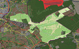
Iringa Region is one of Tanzania's 31 administrative regions. The region covers an area of 35,503 km2 (13,708 sq mi). The region is comparable in size to the combined land area of the nation state of Guinea Bissau. Iringa Region is bordered to the east by Morogoro Region and south by Njombe Region. On the west the region is bordered by Mbeya Region. Dodoma Region and Singida Region border Iringa on the north. The regional capital is the city Iringa for which the city is named after. According to the 2012 census, the region has a total population of 941,238. Iringa Region is home to Ruaha National Park, Tanzania's second national largest park.

São Francisco de Paula is a city in the Serra Gaúcha of the state of Rio Grande do Sul, Brazil. The municipality covers about 3,289.7 km2 (1,270.2 sq mi) and sits about 112 km (70 mi) from Porto Alegre. As of 2020, the city's population was estimated to be 21,801. The municipality was originally created on December 23, 1902.

Juan de Fuca Provincial Park is a provincial park located on the west coast of Vancouver Island in British Columbia, Canada. The park was established on April 4, 1996 by combining three former parks - China Beach, Loss Creek, and Botanical Beach - into one provincial park. It is the location of the majority of the Juan de Fuca Marine Trail, which is a southern compliment to the West Coast Trail within Pacific Rim National Park Reserve.

Chicualacuala District is a district of Gaza Province in south-western Mozambique. It has a population of 41,638 (2011) and covers 18,155 square kilometres (7,010 sq mi). The population density of Chicualacuala District 2.1 residents per square kilometers, significantly lower than the average of 17.5 in Gaza Province.

Chigubo District is a district of Gaza Province in south-western Mozambique. The administrative center of the district is Dindiza. The district is located in the east of the province, and borders with Massangena District in the north, Mabote and Funhalouro Districts of Inhambane Province in the east, Chibuto District in the south, Guijá District in the southwest, Mabalane District in the west, and with Chicualacuala District in the northwest. The area of the district is 14,864 square kilometres (5,739 sq mi). It has a population of 20,685 (2007).

Mabalane District is a district of Gaza Province in south-western Mozambique. The administrative center of the district is Mabalane. The district is located at the center of the province, and borders with Chicualacuala District in the north, Chigubo District in the east, Guijá District in the southeast, Chókwè District in the south, and with Massingir District in the west. The area of the district is 9,107 square kilometres (3,516 sq mi). It has a population of 32,040 (2007).

Massingir District is a district of Gaza Province in southwestern Mozambique. The administrative center of the district is in Massingir. The district is located in the west of the province, and borders with Chicualacuala District in the north, Mabalane District in the east, Chókwè District in the southeast, Magude District of Maputo Province in the south, and with South Africa in the west. The area of the district is 5,893 square kilometres (2,275 sq mi). It has a population of 28,470 (2007).

Mabote District is a district of Inhambane Province in south-east Mozambique. Its principal town is Mabote. The district is located at the northwest of the province and borders with Machaze District of Manica Province and Machanga District of Sofala Province in the north, Govuro District in the east, Inhassoro District in the southeast, Funhalouro District in the south, and with Chigubo and Massangena Districts of Gaza Province in the west. The area of the district is 14,577 square kilometres (5,628 sq mi). In terms of the area, this is the biggest district of Inhambane Province. It has a population of 45101 as of 2007.

Bundala National Park is an internationally important wintering ground for migratory water birds in Sri Lanka. Bundala harbors 197 species of birds, the highlight being the greater flamingo, which migrate in large flocks. Bundala was designated a wildlife sanctuary in 1969 and redesignated to a national park on 4 January 1993. In 1991 Bundala became the first wetland to be declared as a Ramsar site in Sri Lanka. In 2005 the national park was designated as a biosphere reserve by UNESCO, the fourth biosphere reserve in Sri Lanka. The national park is situated 245 kilometres (152 mi) southeast of Colombo.

Ben En National Park is a national park in Thanh Hóa Province, Vietnam. The national park was founded by the decision 33 dated 27 January 1992 of the Chairman of the Council of Ministers of Vietnam.

Arataca is a municipality in the state of Bahia in the North-East region of Brazil. Arataca covers 435.96 km2 (168.33 sq mi), and has a population of 10,961 with a population density of 27 inhabitants per square kilometer. It consists of two districts: Arataca, the municipal seat, and Itatingui.

The Serranía de Chiribiquete or Chiribiquete Mountains are a group of isolated table mountains in the Amazon Region of Colombia. The mountains are part of the western edge of the Guiana Shield. The area is protected as a national park. This area is habitat for the Chiribiquete emerald, an endemic hummingbird. The waterfall Caño Paujil originates from the Serranía de Chiribiquete.

Many areas of Vietnam are under protection. While the national reserves cover small areas of scientific significance with restricted access, the national parks also cover wetlands of Ramsar designated areas and BirdLife International inscribed bird areas. The largest of the national parks initially covered were the Cúc Phương National Park, the Cát Tiên National Park, and the Côn Đảo National Park which to start with were forest areas cum reserves or prohibited areas. The objective for creating national parks was to allow access to the reserved areas as a part of ecotourism and cultural needs with full attention to the basic approach of conservation of natural environmental resources.

Waterton Biosphere Reserve is a UNESCO Biosphere Reserve encompassing Waterton Lakes National Park in the extreme south-west of the Province of Alberta, Canada. The reserve includes a section of the east slopes of the Rocky Mountains extending from the Continental Divide to the edge of the Canadian Great Plains to the east. The Glacier Biosphere Reserve and National Park in Montana, USA is located to the south of the area. The reserve is administered by Waterton Lakes National Park and the Waterton Biosphere Association.

The Niagara Escarpment Biosphere Reserve is a UNESCO Biosphere Reserve located in Ontario, Canada. The reserve stretches 725 kilometres (450 mi) along the Niagara Escarpment from Lake Ontario to the tip of the Bruce Peninsula. The Escarpment corridor crosses two major biomes: needle leaf forests in the north and temperate broadleaf forest in the south.
La Encrucijada Biosphere Reserve is a UNESCO Biosphere Reserve situated in the Pacific Coastal Lowlands physiographic region of Mexico. It covers 144,848 hectares (559.26 sq mi) stretching over six municipalities in the Costa de Chiapas. It is composed of two large coastal lagoon systems that correspond to two core areas, and a wide variety of natural ecosystems including mangroves, zapotonales, tule swamps and marshes, as well as patches of tropical seasonal forest, coastal dunes and palm trees.

Uzhanskyi National Nature Park is a protected area in Ukraine. It is located in Uzhhorod Raion of Zakarpattia Oblast, at the border with Poland and Slovakia. The park was created on 5 August 1999 and has the area of 39,159.3 hectares (151.195 sq mi). Since 2007, it is part of the World Heritage site Primeval Beech Forests of the Carpathians and Other Regions of Europe. It is also part of the East Carpathian Biosphere Reserve. The park was created to protect pristine beech forest of the Carpathians.