This section needs to be updated. Please help update this article to reflect recent events or newly available information.(August 2016)
Historical population of Birmingham, England
Birmingham city's total population was 977,099 in 2001. The 2005 estimate for the population of the district of Birmingham was 1,001,200. This is the first time the population has broken the 1,000,000 barrier since 1996.[7] This was a population increase of 0.9% (8,800) from 2004, higher than the 0.6% for the United Kingdom as a whole and 0.7% for England. It is believed to have been caused as a result of increased numbers of births, increased migration and a decrease in deaths in the district.[7] The population of Birmingham is predicted to increase, though it cannot be predicted at certainty due to fluctuations in previous years in migration. The population in Birmingham is predicted to increase by 12.2% (121,500) from 992,100 in 2003 to 1,113,600 in 2028. This is an increase of around 4,000 - 5,000 each year until 2028.[8]
The mid-year population estimates from previous years show a general decrease in the population of Birmingham from 1982 to 2002, before beginning to increase again up to 2005, with the increase from 2004 to 2005 being the largest population increase recorded. Though, in total, the overall decline in the population of Birmingham has been by just over 1%. The dependent population (0-14 and 65+) has declined since 2001 as the working population (15-64) has increased.[7]
The ward with the lowest population following the boundary readjustments of 2004 was Ladywood with 14,801.[9] Prior to the boundary readjustments, it had a population of 23,789.[10] The ward with the highest population following the boundary readjustments of 2004 was Sparkbrook with a population of 31,485, which is an increase from 28,311 prior to the boundary adjustments.[11]
Age
Birmingham has a young population compared to England as a whole. The mid-year population estimates of 2005 estimate that Birmingham has a younger age structure compared to England, with a higher proportion of the population of Birmingham being under the age of 34, and lower proportion being above the age of 35, than England.[7][12] In the 20 to 24 year age group, the proportion in Birmingham is about 2% above the national figure.[13]
23.4% of people were aged under 16, 57.7% were aged between 16 and 59, while 18.9% were aged over 60. The average age was 36, compared with 38.6 years for England.[13]
The district of Ladywood was found to have the lowest proportion of people who are 60 years and over than all other districts. Sutton Coldfield district had the highest proportion of people aged 60 years and over. Hodge Hill was found to have the highest population of people from the age of 0 to 15 whilst the districts of Edgbaston and Sutton Coldfield had the lowest.[9]
Population density
The population density is 3,649 people per square km compared to the 377.2 people per square km for England. The district of Hall Green had the most persons per acre at 55.22. Sutton Coldfield had the lowest number of persons per acre at 15.47, a difference of 39.75.[14]
Gender
Females represented 51.6% of the population whilst males represented 48.4%. These percentages are above and below the national, regional and county average respectively.[14] However, the 2005 mid-year estimates recorded that there were more males in the city up to the 35-39 age group. 66% of the population of Birmingham that were aged 80 or over were women, and the population of women who were aged 80 or over was 5% of the Birmingham total, as opposed to 3% for males.[7]
The district of Ladywood had the highest percentage of males in its population at 49.7%, whilst Northfield had the lowest at 47.45%. The ward of Ladywood was the only ward which percentage of males exceeded 50%, with a figure of 50.74%. Shard End had the lowest male population percentage at 46.68%.[14]
Ethnicity
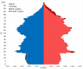
Ethnic demography of Birmingham from 1951 to 2021Ethnic makeup of Birmingham in single year age groupsPopulation pyramid of Birmingham by ethnicity in 2021
The following table shows the ethnic group of respondents in estimations for 1951, 1961, 1966, 1971, 1981 and in the 1991 to 2021 censuses in Birmingham.
Estimates vary for population sizes', in 1958 the official estimate by the Home Office of individual groups for Birmingham's 'coloured' population was around 20,000 Afro-Caribbeans, 7,000 Pakistanis, 2,000 Indians and 450 West Africans roughly,[15] which is around the same total amount given for the 1961 estimates by Philip Jones.[16]
These detailed ethnicities are based on the self-designation entries used in UK ethnicity classifications. Of the "White" ethnicities, after European Mixed (7,138) shown in the table above, the next largest were White unspecified (2,539), Other Eastern European (2,301), and Roma (1,833). After Afghan (5,293), the next largest in the "Asian" ethnicities include Filipino (2,311), Other/unspecified (1,778), Vietnamese (1,681) and Sri Lankan (1,672); there was also a population of 2,138 Iranians in the "Asian" category, however a significant number (1,857) self-identified under the "Other" category, instead of "Asian". Similarly, there were 1,297 Sikhs who identified themselves as "Asian", but a larger number (4,842) identified themselves as "Other".[25]
The next largest entries of the "Black" ethnicity group, after Nigerian (5,764), were Eritrean (3,020), Other/unspecified (2,467), Somalilander (2,261) and Ghanaian (2,229). In the "Other" ethnic category, the largest groups after Sikh (4,842) were Kashmiri (4,086), Kurdish (3,540), and "Any other ethnic group" (2,360).[25]
UK born and foreign born in Birmingham in 2021. Males and females representing the UK born population while foreign males and females representing the foreign born population.
Of Birmingham's residential population of 1,144,924 (2021 census), a large majority of 721,108 identified themselves as solely "British" and 119,732 identified as "English", while 110,753 identified as "English and British". 2,826 identified as "Welsh", while 1,199 identified as "Welsh and British". 155,501 residents had a non-UK identity, while 27,015 had both a UK and non-UK identity.[25]
Languages
The most common main languages spoken in Birmingham according to the 2011 census are shown below.[37]
It's worth bearing in mind that according to another study that references 2011 census data, Polish becomes the second most popular language, behind Punjabi, within the West Midlands Region, of which Birmingham is the largest constituent.[38]
Religion
Religious makeup of Birmingham in single year age groups in 2021
In 2001, the main religion in Birmingham was Christianity, as 59.1% (577,783) of the population were Christians. The second largest religion was Islam, adhered to by 14.3%. Meanwhile, 12.4% of the population had no religion.[39] 8.39% (81,959) did not state their religion, above the national average of 7.7%.[40][39]
Birmingham's percentage of Christians is below the national, regional and county average. The percentage of Muslims in Birmingham is above the national, regional and county average, as are the Buddhist (0.3%) and Hindu (1.98%) percentages. The Sikh percentage, 2.93%, is higher than the national and regional percentage, yet below the county figure. The percentage of Jewish population in Birmingham (0.24%) is higher than the regional and county average yet almost half that of the national average.[40]
There were only 21 out of 354 local authorities in England where the proportion of self-described Christians was lower than that of Birmingham. There were only six authorities with a higher percentage of Muslims. Birmingham's total Muslim population of 140,033 was the highest of any local authority area.[39]
The majority of people classifying themselves in one of the White or Black ethnic groups said that they were Christian. At the same time, 29.6% (1,840) Black Africans and 10.8% (1,581) people from the White 'Other' ethnic group said they were Muslim. Over 90% of people in the Bangladeshi and Pakistani groups said they were Muslim. Indian people in the main, said they were Sikh (47.9%) or Hindu (32.7%) . Over 50% of Chinese people said that they had no religion and 18.3% were Buddhist. There were 42.6% (2,605) people from the 'Other' ethnic group who said they were Muslim and 26.6% (1,622) who said they were Christian.[39]
The majority of Christians lived in the north, east and south of Birmingham, on the outskirts of the city, with far fewer living in inner-city areas. 51.7% of Birmingham's Hindu population lived in six wards of the city; Handsworth Wood (2,461), Springfield Sparkhill, Sparkrbook, Small Heath, Alum Rock, Ward End, Saltley, Bordesley Green, Washwood Heath, Stechford (2,023), Lozells and East Handsworth (1,761), Soho (1,699), Hall Green (1,224) and Sparkbrook (845). Almost 65% of Birmingham's Jewish population lived within five wards of Birmingham; Edgbaston (586), Selly Oak (361), Moseley and Kings Heath (321), Bournville (131) and Erdington (104). 71.7% of Birmingham's Muslim population lived in seven wards of Birmingham; Sparkbrook, Sparkhill, Small Heath, Alum Rock, Ward End, Saltley, (19,372), Bordesley Green (18,629), Washwood Heath, Stechford, (16,847), Springfield (13,461), Aston (12,381), Lozells and East Handsworth (10,853) Nechells and Bromford (8,822), all inner-city wards. The majority of Sikhs were found to live in the west and south east of the city. The ward with the highest proportion of Buddhists was Edgbaston at 1.4% (257).[39]
The following table shows the religion of respondents in estimations for 1991 and in the 2001, 2011 and 2021 censuses in Birmingham.
Distribution of religions in Birmingham according to the 2011 census.
Christianity
Islam
Judaism
Hinduism
Sikhism
Buddhism
Other religion
No religion
Sexual orientation
Of all usual residents aged 16 or over (889,624) in the 2021 census, 779,053 of these identified as "Straight or Heterosexual". 11,968 identified as "Gay or Lesbian", 11,258 identified as "Bisexual", and 3,580 identified as any other orientation. 83,765 did not answer.[25]
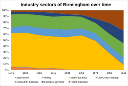
The majority of Birmingham works in the service industry, with manufacturing which used to take 50% of jobs collapsing in proportion of industrial sector in the latter half of the 20th century.
219,427 residents in Birmingham were said to be in 'Not Good Health' (2021 census).[25]
Obesity
29% of the adult population are classified as obese, while the European average is 14%. A quarter of Birmingham's 11- and 12-year-olds are considered obese.[citation needed]
Education
This section is empty. You can help by adding to it. (September 2023)
Housing
The following table shows the accommodation type of all usual residents in households in Birmingham (2021 census).[25]
Accommodation type
Population
Whole house or bungalow
927,835
Whole house or bungalow: Detached
141,217
Whole house or bungalow: Semi-detached
436,846
Whole house or bungalow: Terraced
349,772
Flat, maisonette or apartment
189,335
A caravan or other mobile or temporary structure
677
Tenure
Of 423,456 households as of 2021, a majority of 226,657 owned their home (of which 114,967 owned outright and 111,690 owned with a mortgage or loan or shared ownership). 196,799 households rented their home (of which 99,499 rented socially and 97,300 rented privately or live rent-free).[25]
↑"School and pupil characteristics". webarchive.nationalarchives.gov.uk. Archived from the original on 31 October 2012. Retrieved 8 November 2022.{{cite web}}: CS1 maint: bot: original URL status unknown (link)
↑Joly, Danièle (30 September 2020). Blacks and Britannity. London: Routledge. p.147. doi:10.4324/9781003073413. ISBN978-1-003-07341-3. Of the 177,965 pupils in Birmingham schools during 1998/99, 59.3 per cent were white, 6.8 per cent Afro-Caribbean, 16.5 per cent Pakistani, 6.8 per cent Indian, 3.6 per cent Bangladeshi and 3.6 per cent of 'mixed' heritage
This page is based on this Wikipedia article Text is available under the CC BY-SA 4.0 license; additional terms may apply. Images, videos and audio are available under their respective licenses.


 Christianity
 Islam
Islam Judaism
 Hinduism
 Sikhism
 Buddhism
 Other religion
 No religion